Good Tuesday afternoon. A major winter storm is developing in the deep south and will ride northward along the east coast over the next few days. This will be a shutdown storm for many in the south and east and has an increasing shot at impacting the weather in Kentucky.
A Winter Storm THREAT is now up for southeastern parts of the bluegrass state. This is for the POTENTIAL of 4″ or more of snow to fall. Here’s a look at the threat outline…
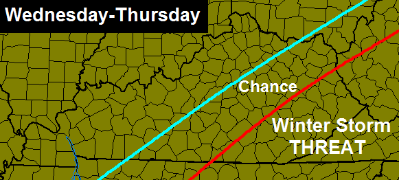
The farther southeast you live, the better the shot at seeing accumulating snow from this. I added a “chance” area to account for a possible westward jog in the track of the storm. That’s something I will be watching for as the upper levels aren’t far from pulling this thing west a bit.
The THREAT means this is possible and if my confidence increase, an alert will be issued. If it looks like the 4″ snows will be to our east, I will downgrade.
Keep checking back for updates and tune in to WKYT-TV starting at 4.
Take care.

go west
Anyone from outside Pulaski co. ever notice that Pulaski co. tends to always be on the line, regardless? We are either too far south, west, north and sometimes east. Southcentral ky gets the worst winter weather… You in the east get more snow, the north gets more snow and ice, the west gets more snow. South central gets cold rain.
That’s the way it always is. Pulaski/Wayne miss out on any action there is 🙁
Go west, young man!!
This may be our one and only shot at some serious snow in south central ky. Yes, move west!
Maybe this one will be Southeast, KY’s BIG snow of the year!!! Last BIG one then warm up and wait on spring. One more big one than ready for spring. Please track west!!!!! Looking forward to another update later. Thanks, Chris for all you do, hopefully you will tweet later that is trending more west.
Bam!!! Looks like Chris is along with the stations out of Knoxville and The Weather Channel for 4″+ for SEKY.
WBIR Knoxville just down “downgraded” to 1-3 inches along the TN,VA,and KY borders.stating he thinks the low will move farther east. Hope he is wrong….
Hmmm. Map on website shows us 3-6″?
It was on their 12 o’clock newscast
Im praying it moves EAST and away from Kentucky!!!
i pray it moves west and on top of your house just for that 😛
I’ll second that.
Any ice for us this time?
At least at this time, the Weather Prediction Center is showing Kentucky to be mainly snow. Perhaps a hint of ice in extreme southeastern KY, but even here it would be mainly snow.
East Tennessee could have some freezing rain issues, but the most destructive icing is forecast to be confined to Louisiana, Georgia, and especially the Carolinas.
Likey what the RUC is showing..Also the Euro,Canadian,ukmet..The Nam,GFS are jokes..
nothing to see here, maybe 1-3 inches towards border counties.
NWS Morristown, TN…
…WINTER STORM WATCH REMAINS IN EFFECT FROM WEDNESDAY MORNING THROUGH THURSDAY MORNING…
* EVENT…SIGNIFICANT SNOWFALL ACCUMULATIONS OF 3 TO 5 INCHES POSSIBLE WEDNESDAY AND WEDNESDAY NIGHT.
* TIMING…MODERATE TO HEAVY SNOW BEGINNING MID MORNING
WEDNESDAY AND CONTINUING THROUGH WEDNESDAY NIGHT.
* IMPACTS…DRIVING AND WALKING MAY BE DIFFICULT ON UNTREATED ROADWAYS AND SIDEWALKS. BE PREPARED FOR SNOW COVERED ROADS AND LIMITED VISIBILITIES. IF YOU MUST TRAVEL…SLOW DOWN AND ALLOW EXTRA TIME TO REACH YOUR DESTINATION.
Well this one kinda scares me…up the east coast and it’s february….and we have not had 3 inches all winter!!!! will I get enough for snow cream this time???? 🙂
What does this mean for chance areas listed? Nothing at all or some impact just not 4 inches??
another thing DRY AIR will eat at precip here as well thT TRIES move in to far SE..
What?
Good luck to southeast KY….hope you get the snow you’ve been looking for. If not this time, maybe soon. Don’t give up yet.
Will be watching this one from the sidelines in North-Central KY. Hope you snow deprived folks get a nice snow.
I’ve had my share of snow and could really care less if i see anymore..I’m ready for spring..Hoping the Southern counties get a good one since there the one’s who haven’t seen much..
Euro stay’s about the same..Pike.Harlan and bell in the 6 inch range..Everybody else in the 2-4..Far Eastern Pikeville is close to the 12 inch mark..What a difference this would have been if it was more westward..
I don’t know were sum u get ur info, but we hvnt been DEPRIVED of snow down here. we hadOVER 10 INCHES this year in Clay Co
Clay co. is not the only place in SE Ky. rolo. South and southeast has had a very dry winter.
I’m with you rolo..Everybody for some reason thinks Eastern Ky has seen no snow..The last time i checked we had about as much as Northern Ky..lol..
Have you had 40 inches like I’ve had plus Ice and sleet and below zero temperatures on MANY a morning?
Yes..
to bad we don’t all live in Clay County Rolocoaster
Hopefully the storm system will trend just a little west…could be our last shot at a good snowfall this winter here in Eastern Pike County.
You’re in a good spot..According to the Euro you’re close to the 12 inch mark..
Fingers Crossed 🙂
Andy’s area of state hasn’t had vrry much snow rolp. Clay co has been a tad more lucky then points south of us have.
rolo your neighbor Laurel Co hasn’t had hardly any snow and the temps have stayed the about the warmest in the state all winter, so yes some of se ky has been deprived. look at poor andy, the birds and deer have pooped deeper than the snow he’s got.
I’m in Laurel County and have had snow seems like just every few days. We have had enough to make snow cream 3 different times.
We had a storm in Jan 1996 that looks like this one where southeast KY is in line, that year they said frankfort would get an inch or less and south and east ky would get several inches!
Not saying this is going to happen this time but that year the storm shifted way to the west the day of the storm and frankfort and Louisville got over a foot of snow!
I think most of southeast KY has a good shot of snow coming!
What day was that ??..On January 6-7 1996 Eastern Ky got mauled with a huge snow..Jackson office received over 15 inches of snow..I remember it well because i had to take the wife to work in Hazard..
That was probably the same storm!
Chris, I loved and followed your blog when you were at WSAZ. I still read you even though you moved a little west. I live near Charleston WV and we have been slighted all season. All rain from the big storms then 2 inch or less snows from clippers. NWS in Chas. shows us on the outside looking in (again). But they are notoriously late on putting out alerts. I just hope we get something more than 2 inches. Keep up the good work. You are the most dedicated meteorologist I have watched and I am 50 yrs old. Miss you here but I still follow you. I hope any model other than NAM or GFS is right.
Yeah, I live in Milton, WV and still enjoy following Chris. Just tired of all these near misses. Would love to see a good snow. So far it has been a lot of anklebiters with frigid temps.
Accuweather is saying 70% Snow and up to 4″.
For Middlesboro
Radar looking like northern edge of precipitation shield moving ENE out of TX/OK into Arkansas. If this holds, SE KY has a good chance of snow. Does anyone have any official report/latest model runs that supports this hypothesis?
Both Dallas/Ft Worth and Waco TX are currently reporting freezing rain.
My brother in Cleveland, Georgia (far northeastern part of the state) reports that his employer is basically shutting down today and Wed due to the upcoming snow/ice storm there.
While I want spring, ironic that Nashville TN and Bowling Green KY can hardly buy snow this winter (just bitter cold), yet points farther south are getting more snow/ice than they want. My parents in the Chattanooga/Cleveland TN area could get 3-6 inches snow Wed.
Hey, Blizzard Tim, looks like your wish is about to come true 🙂 .
Im keeping my fingers crossed..nws in Morristown has my county in 6-9″ zone!!
Stop stealing my snow 😉 Your in TN not allowed to have any 😛
When is this supposed to start? Morning, afternoon,or night?
Chris, how is storm tracking now? Let us know, even if it is just a tweet, to what the storm is looking like to you as of right now. Thanks!!!
Who or what is WSi…You know there map is wrong but still gotta love it..lol
a very quiet day with the comments today …usually with healthy snow around, this thing would have 100+ comments by now ..kinda strange
Prob cause only a small piece of KY has a chance. Lol
even still, the way systems like to come back to the NW …it wouldnt take too much of that to include alot more people in this snow …which i think it will do to atleast some extent
Your right!!
Could be because a lot of people cringe when Eastern and Southeastern Ky get’s snow..Especially a whopper..
I wonder how the temps being 15-20 degrees above forecast today is going to affect this system
That would be dependent on which forecast you watch, the one I watch was forecasting 31 degrees for Southeastern KY.
The forecast WKYT for here was 25 and its 40 so that is why i asked how it would affect
WYMT forecast 31, here in London it is 32. So here’s hoping for one huge overachiever then lets move on to springtime.
it was 39 up by Jaspers at the Big Red Barn about 2 hrs ago. And i’m with you on the overachiever i am ready for spring either way.
Maybe, but I find that hard to believe unless someone had a malfunctioning thermometer or the thermometer was in direct sunshine.
I was actually in a shaded area on the back side of the barn
Since it was on the barn is why it was showing the temperature to be warmer than it actually was.
who said it was maybe your thermometer is faulty works both ways 😉
I have nothing to add, I juxt think it is funny when the letters go down the page like hits…
You’re the one who said it was on a red barn. Wood absorbes heat especially painted wood which would in turn cause a false reading on a thermometer. Common Sense. 😉
Wouldn’t we have advisory out by now if we were going to get much? When does the next models run? Thank you.
It’s prob not gonna snow, but I’m not betting on it.
Laurel County may have had around 3 1/2 inches thus far,not much compared to our neighbors to our East and North. Maybe just maybe this storm finds a way to give us the cold temps and moisture (snow) and we get 4 or so inches for just a day because the next day it will be gone.
As I stated last night. Southeastern KY should prepare for heavy snow. If this low gets far enough north it may get stuck on the west side of the apps. Wishful thinking here in Louisville!! Have had our share, but I am greedy and want more.
Thanks for the update Chris!
I’m preparing for 50 degree temps
1-4 inches for SE KY
This would be good time to head for Gatlinburg, anyone have a cabin down their?? 😉
Chris bailey just showed my part of knott county in the 3-6 range.
Bailey just posted 3-6″ for Bell Co. Us here in Middlesboro are only 2 miles from a Winter Storm Warning. lol.
Any chance Berea will see any snow?
if you check the map at the top of the post it looks as if Berea, which is in the county the “h” in chance is on. so yes, there is a chance that you might get some snow from this.
Jackson NWS is in talks to issue a Winter Storm Warning for Bell, Harlan, Letcher, and Pike Co’s.
WINTER STORM WATCH has been issued for these 4 counties. 3-5″ is expected.
The Weather Channel has changed their forecast for Manchester 3 times today for the Wed. night event. First forecast was for 1-2 inches, then down to 1”, now down to less than 1”…whut???
I think Chris needs to make a small update now.
kinda hard to do while hes on TV lol
hmmm.. he does have a day time job and a family.
psshhh, WE are his job and family……;)
Canadian has uped amount’s for SE Ky..Me think’s we are going to see an over achiever..Everything is wagon’s west right now..The Light pink and dark blue is ever so slowing entering SE Ky..Joy Joy..
Slowly and upped..lol..rolo i need help..
Found this on the World Wide Web..Snowfall amount from the Canadaian..
http://i.imgur.com/OafjcQY.png
Translation?
Translation for what..The map..
yeah because its all colors no amounts there
Which model has been best close range this winter?
I hope the SE gets so much snow, that they complain about how much snow they get. I just hope no one loses power. or water. that is no fun.
stay safe in the SE counties!
just as expected MOUNTAIN COUNTIES. I stick to my 1=4 inches from clay co east.
Well, this was an interesting exchange…
http://twitter.com/Kentuckyweather/status/433324156659056640/photo/1
yeah we can all read it top right corner
What am I missing? Did not really understand the exchange
Some people are questioning why Chris is posting a snowfall may that he knows isn’t going to happen more or less
Rolo, I thought you moved to Letcher Co?
na BOB im actually in JACKSON COUNTY right now, back and forth from Clay Co.
Wymt says 2-4 for us letcher county but the current track they showed had it missing us all together. Go figure
Well weather channel saying less than inch tomorrow night for knox I guess it’s wait and see
I hope you will add weather cams from the Atlanta areas to the blog! Could be interesting watching!
I said since last nite, there nothing to see here; we got CLOSE TO A OLD SCHOOLER, but close only good in horshoe and gernades..
come on down to the snowpocolypse state of tn….lol…suppose to get 5-9″ in my backyard…
WELL ONE THING IS FOR SURE ! EITHER WE WILL GET THIS SNOW OR WE WILL NOT , SO WITH THAT: JUST BE PREPARED IN EITHER CASE. MY PERSONAL THOUGHT IS THIS. IF IT’S GOING TO COME I WOULD RATHER HAVE IT ALL AT ONCE AND BE DONE WITH . SO OUR KIDS CAN GET BACK TO SCHOOL, WHICH BY THE WAY THEY HAVE HAD ONLY EIGHT DAYS OF SCHOOL SINCE THE CHRISTMAS BREAK,WHICH LEADS ME TO THE REPLY ‘S OF THINKING WE HAVE NOT HAD OUR SHARE OF WINTER THIS SEASON.. IN EITHER CASE THE BOTTOM LINE IS BE PREPARED FOR WHAT COMES OR NOT…………….