Good Tuesday to one and all. Our day is starting out with bitterly cold temps in the single digits with wind chills below zero at times. The cold is impressive, but it’s all eyes on the east coast winter storm coming over the next few days. Will it impact the weather here in Kentucky? Let’s get straight into that.
A major winter storm is set to slam much of the south and the east coast over the next few days. This may come far enough west to bring some snow to the bluegrass state. Here’s a first look at the areas having the best shot at seeing this…
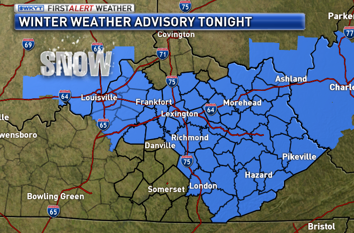
As you can see, the greatest risk is across the southeastern corner of the state. It all depends on the track of the low and the models should get a much better handle on that later today. There is the potential for a decent snowfall for some, but it’s all about the track.
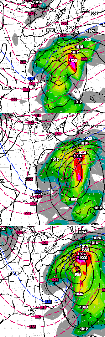
The European Model…
The UKMET…
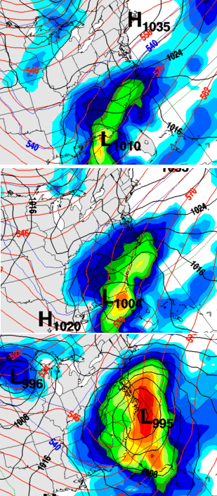
Both of those models are trying to pull the moisture field pretty far to the west. That’s something to watch for.
Looking down the road… a couple of clippers will work in here this weekend. One arrives Friday and another scoots in to round out the weekend. These could be light snow makers for some. The Canadian is really trying to blow up the system for Valentines Day…
The pattern for the middle of next week is looking to break down for a bit. I think we go warmer for several days, but the European Ensembles show things flipping back a few days later…
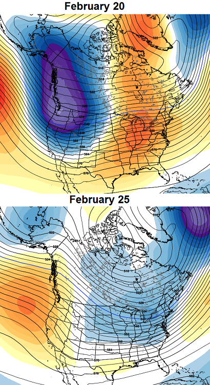 I think winter has one last big push for the end of the month into early March and then it’s finally over. Spring should come on strong and I’m already looking for clues at to what the severe weather season may hold. No… I never stop looking ahead.
Updates will come later. Take care.

don’t want to think about storms chris don’t look forward to that look ahead…
At least I’m in the moderate section for snow probability. I pray it shifts just a bit more to the west.
Planning to surprise the Hubby for his birthday this weekend, It’s not looking so great. Was wanting to get a cabin for our little girls and him. We are in Laurel County. Does it look like we could be getting a big snow? How about Pigeon Forge? Thank You so much Chris Bailey for you do to keep us in the know! You don’t see many weather people that update at 2 in the morning. LOL! Thank You!
Good job Chris I really enjoy your reports and the way you stick to your guns on your predictions.Keep up the good work.
Wow just looking at the radar its amazing how so much is happening south of us.Almost every where above southern Tennessee is clear.Its 10 degrees on my porch thermometer and quiet as can be.I will be surprised to see Ky get much precipitation at all today.Maybe tomorrow.
Not suppose to be any today
thank you Chris.
one last round (… and I’m still hoping for the BIG SNOW ) at the end of the month and then spring?
sounds good to me, all in all – it’s been a good winter….
Looks like our big snow drought miser for the usual areas has probably added year sixteen to “its” trophy table. Going from an average of every two years for a big snow to a gap eight times longer is wild. The good news is the big ice storm average seems to not be getting any more frequent.
4.6 deg at my house this morn! stay warm!!!!!!!!!!!!!!!!
I see a 50 in the official NWS seven-day forecast for next Monday. The normal high for Lexington for today is 44–so that 50 is actually much closer to normal than what we have been experiencing.
NWS calling for 1-3 inches of snow across the TN border from Whitley County and 3-5 across the border from Bell County. Maybe this indicates a westward model trend???
I will take a little bit of snow in the snow starved area where I live (Knox) , but my favorite thing about CBs post is that spring is right around the corner. No way was I wanting to hear that we wouldn’t warm up until mid May like last year. I put my money on CB, he said last year the cold wasn’t going to leave and he was right, glad to hear him say we are actually going to get a spring this year.
It would be nice to have a spring, for a change, when the time is appropriate for it. It seems like the norm anymore is to go way too warm and too quickly, then a freezing shot, then back to early summer (mid 60s and 70s).
Congrats to Harrison County Mesonet for being the lone station to go below zero overnight in the entire state. You win a No-Prize!
winter storm watch for here in athens,tn…3-5″ of snow expected wednesday and wednesday night…
Yeah accuweather has a little notice that we can expect 1 to 3 inches for this area from Wednesday afternoon through Wednesday night.This one is going to be interesting to see how it turns out.
CB has finally gave in and mentioned the warm up next week. Guys, winter is wrapping up across our area. Just some more snow and cold left until end of Feb and March. If we get snow, great, if not, great! I’m ready for warmth and thunderstorms! Btw, both GFS and Euro show a couple 60s to come with this next week!
06z NAM and GFS bring the snow a little farther west. They are starting to match up more with the Euro and Canadian models, just as CB said they would.
06z NAM
http://wxcaster.com/gis-snow-overlays2.php3?STATIONID=JKL
06z GFS
http://wxcaster.com/gis-gfs-snow-overlays2.php3?STATIONID=JKL
The GFS numbers may be skewed a little bit from the snowfall on Friday too. Maybe it’s not coming more west for the Wednesday system.
So much for your map reading skills. I jest 🙂
That is actually worse than yesterday for my area. Even Pikeville gets less in that run.
I thought that things would have to turn warmer soon. With the cold that we have had, we have to eventually get some temps to get us closer to normal. My crew has some activities that require us to be outside a lot during March, April, and May. It was no fun wearing two and three layers of clothes during April last year. I would much rather have a good winter and let it leave when it’s supposed too. Last year was miserable.
Are you a softball or baseball umpire? My daughter is a softball fast pitch highschool pitcher in Bowling Green,Ky,and that is the same time frame of her season. And boy did we ever freeze our tails off last year.
18 here in knott co this morning
Just a little more NW shift is all we need today..Some area’s could receive 6-10 inches or higher if we get that last NW shift..Northeast Tenn looks like it will do well..That will bode well for our area if we get the NW shift..
well after looking things over there is NOTHING TO SEE HERE. I first thought we getit as we always see a NW jog. but itsnot happening as the MOUNTAIN Counties MIGHT see couple inches at best
Perhaps a better reply would have been:
IT ISN’T COMING
or
IT MIGHT COME A LITTLE TINY BIT
Will the real rolo please stand up..We all know the real rolo would be saying 2 feet of snow..
Rolo said that yesterday, but I think did not realize how much shift it would need, even to give a few inches for most in East Kentucky. Needs a big shift for a few inches and a mega chunga shift for more than that.
He didn’t say 2 feet though, but just that the storm was coming.
Well, if rolo says it’s not happening, then we had all better get out our snow shoes!
Glad to see your back to your old self Rolo
I can not wait until SPRING!!!!!!!!. Chris, thank you for all that you do for us in keeping us posted on the weather. Hat tip to the greatest weather man ever.
Figures the one time we need a northwest jog, and it does not happen. As this storm busts for e ky, I’m now officially in spring mode. Tired of gray skies, crunchy ground, school closings, cold wind, short days. Snow or no snow, this has been a long winter
Can’t be a bust because it was never forecasted 😉
I give up, I’m moving to Key West 🙂 Sooo Tired of snow, guess that’s the price one pays for living in Eastern Kentucky 🙁
You could be my neighbor Barb 😉
Are you moving to Key West too..haha.. Oh I forget, you’re snow starved…haha
Channel 8 out of Knoxville still showing 5-7″ of snow for Middlesboro and Harlan. Sister station to WYMT.
They did say that was a “worst case scenario”. Not a likely scenario. I still think far SEKY sees a few inches from this though.
Hooray, spring! I am so ready! Hoping it will warm up and stay warm. I don’t want to put on a coat for many, many months.
Hoping this winter still has one or two surprises left. Still hoping for a 6″ plus event here between Huntington and Charleston, WV. I usually don’t give up on winter till mid march as some of our bigger events have come during the transition between seasons.
Checking out national radar….has anyone notice the growing system in Texas?? Is that what may or may not clip Kentucky? It looks to be drifting NE already. It may be wishful thinking, but I’m not sold on the near-miss just yet. Still odd to have such a range of forecasts within 24 hours of event.
Spring can roar in here like a lion with all the rain and wind it wants, so long as it’s warm. Thanks for all of your hard work, CB!
Not going to be much of a Northwest trend when they get on the *East* side of the appalachians. Mountains will keep it to the east of us. Can happen, but not as likely. When they are on the west side of the apppalachians, there is a natural push from the mountains to keep it west of us. Then warm air gets pulled in on the eastern side.
Would expect this one to stay a southeastern Kentucky storm if that at all.
I hope southeast KY gets some snow. This is one time I could care less about us getting snow. But I do have to ask………since I keep reading comments about weak lows staying south and the stronger lows moving northwest……….so is this not a strong low? It sure looks like one based on forecast accum’s for western NC.
It is strong. If it was weak, then it’ll go out to sea, but it has to get REALLY strong to move northwest into our area.
People are putting too much stock in faulty models.these same models showed charleston getting5 -10 inches out of the last systems enen during the storm. People always say follow the trend well the trend this year has been a northwest shift every time. Don’t give up hope
Good luck to those of you in SEKY with this system. I’m predicting those of us in CKY are done with decent snows for the year, meaning no more snow days in Lex or surrounding areas. I’ll call this winter a fair success in this area. Hope you guys down south can get a decent one.
Februrary 20! 🙂
And did I see someone type “severe”? More 🙂
I hope that everyone that has missed out on the snow this year gets at least one good one. I have slipped around enough in Lexington this winter and am so ready for warmer and sunnier weather so we can melt off this snow and ice. That CB for all you do and if you don’t mind Barb,will you please get me an extra ticket to Key West? I am with you on that idea.
The NWS out of Charleston now has Olive Hill, Ky, where I live as having a 20 percent chance if rain/snow for Wednesday day and 30 percent chance of snow for Wednesday night. This is a big change from earlier when they said nothing… Could this mean a northwest shift??????!!!!!!!
12z NAM went east, 12z GFS went west. Can’t say I’m surprised.
GRRRRRRRR. The 12z NAM and GFS is not very impressive at all. Maybe one or two more runs is all we got. Perhaps as the storm actually begins, a NW trend will start. who knows.
We have another 4+ weeks of winter possibilities, folks, Not uncommon to get some 50s and 60s in mid-late February but we’ve seen big snows in March before. In fact, most of those March snows were right after big warm-ups.
first thiss is not aBUST!!! geesh some u are nut cases. 2nd the NWEST Trend doesn’t happen all the time either. so shut up. 3rd its not happening this time either. the BORDER COUNTIES should see sum light snow but that bout it.
Why so down rolo..Me thinks some are in for a surprise..
can someone post what the canadian and Euro showed (12z). Never can seem to find them.
They are pretty hard to find unless you pay for them. If you follow WxRisk.com on Facebook he usually posts them as do some others.
Euro come’s out around 1:30….Canadian a big Hit for eastern Ky..
Here’s the snowfall map in Qpf
http://twitter.com/RyanMaue/status/433270926449180672/photo/1/large
Not a bust here, ky was never a big player in this from the get go, border high elevations may see an inch or two
The Weather Channel has now jumped on board with 3-5″ for far extreme SEKY.
The weather channel is a joke!
Well clouds have messed with morning lows in the south and afternoon highs are off as well. We are already 5 degrees above forecast and its just about noon
Hi Andy 🙂
I warm sounds fine with me at this point, winter started early in Franfort this year flurries in October and over 1 inch of snow in November!
This is day 10 with atleast 4-6 inches of snow and ice pack here and I
Im at 22 inches or so in my yard this year, and many mornings below 0, so if spring is coming early I’m ready!
Been a great winter in frankfort!