Good Friday, folks. Gusty winds will continue to blow across the bluegrass state today and into the start of the weekend. These winds will eventually usher in the return of Old Man Winter as we roll into next week. More cold and snow chances are just around the corner.
Highs today will hit the 40s for many areas under a partly sunny sky. Those winds will be rather gusty and could top out at 35 to 40mph at times.
Saturday will see the winds come down and the temps go up. Highs will spike into the 50s under a mostly sunny sky.
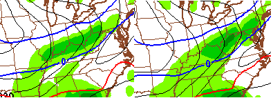
Things begin to change on Sunday as a cold front drops into the state. Some very cold air is pushing this to the south and we are likely to see a wave of low pressure develop along this boundary. That may deliver a band of light snow to parts of the region late Sunday into Sunday night. The NAM shows what I’m talking about…
A stronger push of arctic air will work our way by the middle of the week. That may be accompanied by another wave of low pressure just to our south…
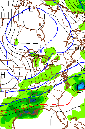
We will watch to see if that can bring another round of some snow into our region. Regardless, the air coming in behind that is darn cold!
Our old friend from the north even tries to pay a visit to the Great Lakes by late next week…

That would be nice way to usher in March… a frozen lion.
More on all that later today. Take care.

i usually expect spring about 2nd week of march. this year, im thinking it may be a repeat of last year, first week of april till we see any true spring arive. I was thinking 4th/5th april temps started warming up last year.
Now that the severe threat is over, try get a litte rest chris. thanks for all that you do for the public.
I enjoyed the warmer temps the past few days. Seasonable weather sounds good though it looks like it is a ways off. On a side note, not sure why all the complaints about cold & snow. This will wind up the 3rd coldest and 3rd snowiest winter of the last 5 in Lexington. We’ve had a bunch of mild days to balance out the cold.
Not everybody lives in Lexington though
Still have around 300 lbs of salt. Would like to use it before old man winter is through. Winter runs through March 20th. Let it snow until then, after that I want to get the mowers out.
Thanks CB for all you do.
Go home Polar Vortex….You’re drunk.
That was exactly what I was thinking.
Me too. Please. CB,make it stop. I am so done with this weather. I have a bad case of Spring Fever. Great job last night Chis B for keeping us up to date on the tv about the severe weather. Hey Bubba,did that wind knock the dome off of Richmond? Making sure you’re ok buddy. And please Andy,could you please get your blowtorch out and send that polar vortex back to north? So ready for warm weather.