Good afternoon, everyone. Winter is on the way back, but that should come as no surprise to those who have been reading the blog. This has been talked about for weeks and I called this week’s weather a “false start to spring”. As a matter of fact, the period ahead of us could take on a rather harsh tone.
The first shot of winter comes later Sunday into Sunday night with a wave of low pressure developing along a cold front…
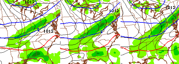
That’s the NAM and is continues to show the potential for a swath of a light snowfall. The Canadian Model is a little more robust with the wave…
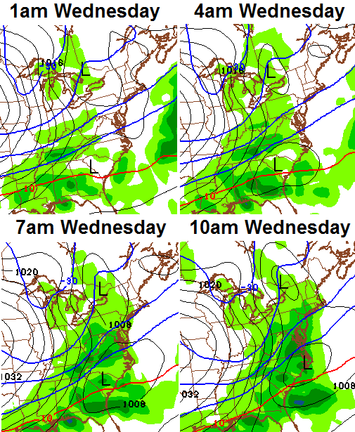
Seasonal chill follows that by early next week as we await a few more waves of low pressure. The first arrives Tuesday with a few flakes possible, but the models are keying in on the Tuesday night/Wednesday wave as having a better chance to develop…
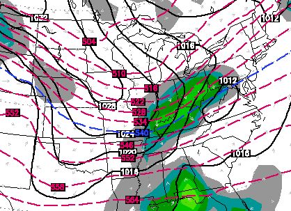
 The Canadian Model is very similar to that and would bring accumulating snows to the region. That setup is pretty darn close to becoming a BIG storm! Another story will be the amount of arctic cold coming in behind this storm. That looks brutal for this late in the season and could send readings into the single digits later in the week.
As I’ve been saying… we have a lot of winter to go.
Take care.

1st
Great comment.
Even better one
The best one
The Shibe is strong here.
Thanks Chris. Guess we now wait to see what happens. Have a great Friday everyone.
Next weeks storm is already making the northwest jaunt. Could get real interesting by mid week. I suspect the southeastern counties could see another heavy snow event unfolding.
It is winter so let the good times roll!!! Spring will be here before you know it. Or will it?
Thanks Chris. And if you can give spring a call and tell her to come back. Old man winter is grumpy and needs a long nap.
I read where the NOAA said January came in as the 4th warmest on record globally. Land temperatures in the southern hemisphere were the highest on record for the month and apparently ocean temperatures are up.
Go ask someone in Minnesota or Wisconsin how concerned they are about global warming 😉
I’m sure plenty of them are — what’s your point?
Global warming is the biggest scam in history.
Not about cold..global warming is about changes, significant changes, in weather patterns and thus climate.
Its crazy cold over there! Duluth, MN set a record number of days of going below zero for and entire season, 60 was the old record, and Duluth seems to be getting at least 70 this winter, that record is going in the dust at this pace.
Which is probably BECAUSE of global warming…
NOAA and scientist are all about the stat keeping, I just wonder if stats went back a 1000 years or so if global warming would be such an issue, this latest warming would be called a normal varible trend instead of gloom and doom and the end of the planet coming??
Hilarious….The records say what reality is and because it snows in Minnesota, we can of course throw global warming out the window? Whatever causes it, the world is warming. Deal with it.
True, the world IS 100% warming, there’s no point in denying a fact. Now it up to you to believe if it’s caused by GW, or natural climate change. I personally believe it’s a mix of the two, but that the warming of the world is faster due to, well, you know. It’s completely normal and natural for one to look out his/her living room window and a-ssume all that GW stuff is a hoax, because it’s cold outside st that moment. Our brains are hard-wired to a-ssume things like that. Your window does not show the whole world.
st
*at
Snowman I didn’t say it wasn’t warming, we have 200 years or so of reliable weather records, earth has been through this before, we have warm periods and also cold periods, GET USE TO IT!
Gosh, imagine how good our statistical climate models would be if they went all the way back to the beginning of the planet. 6,000 years would be a lot of data to help it improve, don’t cha know!
6,000 years LOL, try millions??
Depends on your beliefs
Yep, based on where they place their sensors for data and where they get their money, such a bogus summation is not surprise. Hacks they all be.
After all, who cares about the how when it comes to the money? Koalas Only Care How.
Chris thank you for all that you in keeping us updated on the weather, you are awesome. This past Tuesday and Wednesday was so beautiful and I can’t wait until Spring is here, I am marking the days on the calendar for the warm weather to arrive.
I kept my receipt, can I exchange that forecast for a warmer one?
That’s odd,because our L-Ville mets are downplaying ANYTHING WINTRY for at least the next cpl weeks??! Saying 40’s/50’s and no snowfall and/or winter storms in the next 2 weeks…duh!
I SURRENDER TO WINTER! I GIVE UP!!!!!
Come March 1st, this guy is ready for SPRING!!! The last 2 days were great, would love to place an order for more of that and warmer for the next 9 months or so!
It is beautiful outside this afternoon. The wind has died down–temp 48 in Lawrenceburg. Another nice day for a jog. Looks like Upper 50’s and sunny tomorrow? Love it!
I am going to walk my pooches instead and jog tomorrow. They have cabin fever.
Ok Chris. Saying “Take Care” at the end of a post that contains nothing but bad news (especially for this time of year) just does not let me move on to other things with a warm and fuzzy feeling. Maybe you could start ending the post with some positive news! 🙂
It will be interesting to see exactly where this meterological winter ends up temperature wise. It will be below normal, but not near as far as most think.
Really do not want any more of winter.
When you look at the polar icecaps melting at an alarming rate, the smog in LA and other big cities, the smog in China at an alarming rate that people have to cover their face with mask, and to say we don’t have a problem is sticking your head in the sand. California and other western states are in a drought that has never been seen before. I’m not talking about the midwest dust bowl, I’m talking about the west coast. For those who say that global warming is just a scare tactic, please back that up with true facts, not the facts some politican is telling you. I am 56 years old and at no time in my years have the polar icecaps melt this far.
I find the global warming debate fascinating. Looking at our “micro-climate” in central Kentucky we have accurate records since about 1870 or so. The historical record shows a very warm period in the 10th and 11th century–the Vikings went to Greenland–and tried to settle there. There was also the “Little Ice Age” in the 18th and 19th century. Without a doubt, it is warmer now, on average, than it was 100 years ago. But how does that compare to 1000 years ago or 10,000 years ago? We just don’t know.
Follow the money and the answer is apparent. No money, no incentive to propagate the legend of the ManBearPig.