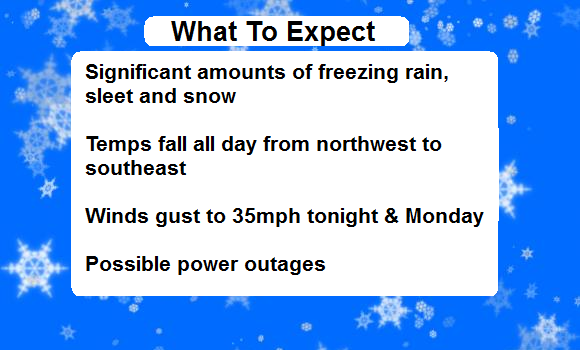
Good Sunday, everyone. A major winter storm is ready to smack the bluegrass state with freezing rain, sleet and snow today into Monday. Significant totals are expected to cause serious issues for travel and may create power issues for some.
Here’s a breakdown of the day…
Cold air is surging into the state today and this is acting like a bull in a china shop. It’s going to push through the region pretty quickly and change the rain over to our wintry mess. Timing the transition for any one area is critical to precipitation type and amounts. Here’s a look at a rough outline of the switch…

This brings up the big question… how much falls where you live? That’s always a tough call, but it’s even tougher when dealing with so many different types of precipitation. Here’s what I’m thinking with freezing rain…
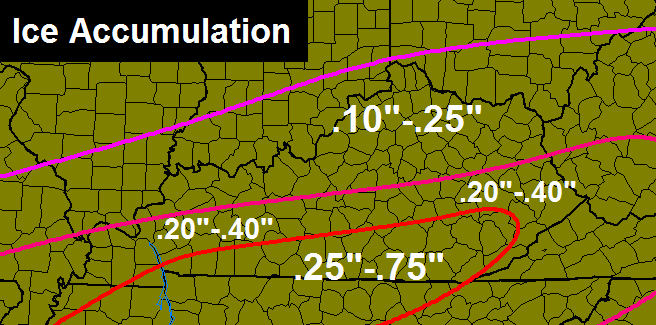
The southern half of the state has the greatest potential for an out and out ice storm. If the high ends of those numbers are realized… power outages are a given. Let’s hope we have a lot more sleet than freezing rain. Sleet doesn’t stick to power lines and trees.
Speaking of sleet… I expect a prolonged period of sleet for many areas this afternoon into the evening. That will then go over to snow late evening into overnight. Exactly when we make the switch is the great unknown and that keeps me from going wild with totals. Sleet doesn’t add up as much as snow does. Here’s a forecast combining the two…
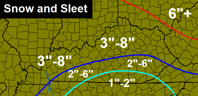
If the snow takes over early enough… the high end of those numbers will be realized and likely exceeded. If sleet holds on longer into the night… it’s closer to the low end.
Remember, all the numbers from above are through Monday afternoon. The worst of this storm is tonight and Monday morning.
I will have a final call coming later today as I see some early trends in how the storm is unfolding. I will also have the tracking toys for you guys. Until then, you have to live with regional radar…

Stay safe and take care.

I say come what may. I am prepared. 🙂
Be safe my friends.
“Hamlincentrism” def. – The universal model put forth on March 2nd, 2014 which quickly replaced the earlier idea of Heliocentrism.
This new model also introduced physicists to the possibility of a dimensional rift allowing humans to simultaneously exist in our reality and within a separate universe existing somewhere inside their own colons. 😉
Oh no! Please no ice!!!! Anything but ice!
So much in agreement with you.The snow I can deal with but do not even want to think about ice.I guess the only good thing I can see in this is it should warm up quickly.Lets just hope trees and power lines aren’t down and lots of damage in the meantime before the warm up can get here.
I suppose its better than a tornado threat.Been thinking about the outbreak in 2012 all day.
I am excited about the snow potential, oh, who am I kidding, I am excited for a flat out winter storm. Finally.
And the nice thing about winter storms in March, if there is an upside, is that the snow and ice doesn’t stick around nearly as long. Heard mentions of 50s again by late this week in central KY.
True,however with an ice storm it don’t have to stick around long to have devastating results.This worries me for sure.
Ice Storm Warnings may be issued later today or tonight if southern Kentucky is expected to get that much ice!
Chris, I know you are tired of Winter as am I, and I also know that you are in full winter storm threat mode, but I was wondering if you can talk about if this is going to be the last hoorah of winter or if we have more, also what has seemed to been absent is a Spring/Severe Weather outlook from the blog. I think that for me has made this winter even more cumbersome because no one is talking about spring.
I honestly think warm air aloft will cause more ice near the louisville area to accumulate before a quicker transition to sleet and snow. I am no pro, but have a gut feeling… Call me out if I bust, but my guess for louisville is .35 ice, .15 sleet, 5.5 snow.
Look at it this way:
The models called for mainly snow two events ago and most of us ended up with mainly sleet. Now the models are pointing out both ice and sleet along with snow. Seems this event will mainly be ice and sleet by that convention for most of us, based on the ice and warm air that will likely hang around to cause the ice and sleet in the first place. A lot of us are probably looking at a topping of snow, but the event of course needs to play out.
Can’t doubt the potential impact of warm air, but perhaps a Dumb and Dumber chance of more snow? I will take that over ice!
looks to me like the cold air is surging in faster than expected.
Thanks Chris, looks like we agree mostly on the setup. It’s time to prepare folks, this one has nasty potential.
Balmy 51 degrees here in Lexington and rain is starting to fall. I’m going to fix some eggs and bacon and biscuits and get my grub on, then back to bed. I hope this isn’t an ice event, but either way my tummy will be full and a long nap and let it do it’s thing. Nothing we can do about it, so just make the best of it. Everyone be safe.
It’s 37 in Frankfort. Dropping fairly quickly. Heading your way!!
36 in NW Lexington.
Sheet of ice here in Indy heavy precip staying north as of now. Last night I was talking with a UPS pilot and he told me that if you don.’to get back to Louisville by 100 this afternoon that you might not make it home.
As far as snow totals, some will be disappointed. Sleet will be persistent. However, some near the transition time to all snow could see at least a half-foot of snow.
I think you gave us a good map CB, as always. You are the WOW. I don’t know if it should be the Wizard of Weather or the Wizard of Weatherdudes. Hmmm.
A lot of Kentucky might want to best case hope for a lot of sleet instead of a lot of ice. The more sleet, the less power issues. Almost half an inch of ice and then 4″ to 6″ of heavy snow would be lights out for a lot of state. Not seeing snow being a big factor for many of us, but as CB said, no way to know right now. I just look at the behavior of previous systems and factor that into the current forecast. Ice and Sleet appear to be the stars and Snow might be a cameo for a lot of areas. Let us hope Sleet gets top billing over Ice 😉
Temps in Louisville dropping temps are sitting between 33-34 and continues to fall
Lightning strikes developing sw ky and southern Illinois
Ok, we have a weather event happening where temperatures will play the critical role. Expect the Ky Mesonet site to go down at some point.
Yes, like it always does.
That is why i like http://www.wunderground.com/ you can look at peoples weather station data and get info that may be just as reliable for your immediate area. I installed my weather station earlier this week and have it reporting to the public.
What could I type on to get your exact location?
my zip 40906 and click station select and look for Mackey Bend
Don’t make the mistake of looking at radar now and trying to determine if forecast for your area will validate or bust. What’s coming from the northwest today is just the advanced guard. The attack is coming from the southwest in the form of that big honking low that will bomb out over KY tonight into the early morning tomorrow.
I know, I know – we’ve heard that before but from all the reports, models, and discussions you can find’ this is a serious weather maker.
I’m thankful my trip to Philly tomorrow was cancelled!
Meh, its not going to bomb out. It peaked at 960mb in the pacific ocean.
Well, looks like Laurel finally gets some action. According to NWS, up to .4″ frz rain, 3″ sleet, the 4″ snow. This could be pretty crazy!! I hate to “have to” go to the store, but this may actually be a need today. Everyone please be safe….enjoy your morning and get home.
Be safe
you too andy…we finally get a winter storm but not too thrilled about this one.
It was a pretty dumb decision to take off the winter storm watch for south eastern ky, now they and the whole state of ky is in a winter storm warning.
Why is it dumb?
Because they waffle
Thunder sleet in Cape Girardeau MO
Thunder with freezing rain and sleet in Hamilton IL
London time reader, few times blogger…
Something tells me that I’ve waisted my time trying to coat the “Dome” here in good old Mad. Co. I think that I will concentrate more on falling tree limbs around my house… I’m thinking that this one is going to bring the Mother Load!!!!
Seriously!!! Long time, not London
Snow dome will likely hold. There never was really an ice dome ;). This puppy has mainly ice and sleet written all over it. CB stressed the low end of those map totals and for good reason. Ice and sleet and a topping of snow seems most likely.
Perhaps puppy is too nice. How about rabid badger?
I live in Somerset and I don’t have a fireplace…can’t afford a generator…suggests please for safe heating source that I can use if we lose power?
kerosene heater
just don’t let it get to close to anything.
Look up:
http://texashelp.tamu.edu/011-disaster-by-stage/prepare/safety-tips-heating-homes.php
Good luck… and be safe!
Cody Lundin authored an awesome book…
When All He’ll Breaks Loose!
http://www.amazon.com/When-All-Hell-Breaks-Loose/dp/142360105X
I would highly recommend a read.
Auto-correct… *Hell
Close off some rooms and center your heat supply in few rooms, before the power goes out. Our kids already want to get all the mattresses in one room for a family slumber party 🙂 Get your blankets and candles ready. You may want to call around and see if you can team up with someone within walking distance, just in case one of you keeps your power. Stay safe 🙂
I have a kerosene heater as well as a Little Buddy propane heater that uses small propane cylinders. I use the Lil Buddy in my garage and basement at times. I bought a few gallons of kerosene in the event the power goes out. Use caution using any type of heat source.
Thanks weather friends…I’m going to get ready and go to Lowes when it open. Hope they still have kerosene heaters in stock!
Agree with kerosene, but be very careful with it. Do you have a neighbor with wood burning heat that you could bunk with if power is out for longer than a couple of hours?
Thank goodness we have a wood burning stove in our home! It’s dusty, and the wood is messy, but I wouldn’t get rid of it for anything. Great to have a back up in the winter months.
temp down to 31 and water just starting to freeze on top of cars
its starting to change from rain to ice
32.3° NE Louisville
33.0 near Iroquois Park.
33.4 Valley Station
Just started raining here in e. carter co. Temps have fallen 4 degrees in last 45 minutes. Is this storm moving in faster than expected?
Temps are dropping fast from NW to SE
Are you more or less confident in snow being a main player? I am less, but that does not mean much.
Is it getting colder faster then expected?
48 degrees and a thunderstorm in campbellsville currently
Wait about 20-30 minutes…
It’s beginning to feel a lot like Christmas…..
Just woke up. It’s 36 in Lexington. Looking outside just has that dark creepy look to me.
The guy over at wxrisk is still very confident in his snowfall map.
He has placed a good chunk of Kentucky in 9-12″ of snow including Louisville/ Lexington metro.
There is usually a correlation between arrogance and erroneous information 😉 We shall see if the case here.
Thunder Ice in Marion. Tree’s starting to cover to white.
Is that blue on radar in west ky really snow?
Very heavy rain in south Lou. It’s a gullywasher.
I just went for a walk around my farm here in southern Jessamine County. It is a beautiful and peaceful morning. 39 degrees didn’t feel so bad. There are definitely some dark skies taking over though. I guess this is the calm before the storm, as they say.
Having flash backs of 2009! We were without power for 11 days during that ice storm and we had friends without for >2 weeks. I’m in Ohio Co and can’t stress enough to have plenty of gas to power your generators!! As gas stations will be closed as long as no power. 1/27/09 was a life lesson I won’t ever forget, good luck and be safe.
The rain started just as soon as I posted that!
31 with rain here. Travelled to and from Bowling Green this morning to get my son back to WKU. On my way back, rain into torrential rain and saw several lightening strikes. Once home, again, heard rumbles of thunder and the rain is pouring. I’m not sure if it is sticking to anything yet. Gonna be a long couple of days.
Hi everyone! Good luck today. Does anyone else think it seems the temp drop is happening a little quicker than anticipated in central ky ( in Mercer co. ).
I just left Kroger in Harrodsburg and the rain has something in it.
I wondered about that Joyce. Looking outside I swear I see some sleet.
Bleh! I just cleaned up the limbs from the last ice storm. Let’s hope that “in like a lion, out like a lamb” thing holds true. Thanks for the updates, Chris.
Down to 31 in Frankfort with precip moving in, no plain rain here today!
32 in Lawrenceburg down from 36 at 8:00. Looks like frozen precip will begin in earnest soon.
Dropped 8 degrees in the last 2 hours here in east Lexington. Both thermometers now showing 33F. Seems like it’s getting colder a lot quicker than NWS forecasts. NOAA predicted 31F by 5pm. At the present rate, we’ll be at 31F before 10am.
Hopefully this means the air aloft is getting colder at a similar rate else we could be looking at more freezing rain than predicted…
Supposed to go to Rupp today. Since they won’t cancel, trying to decide whether or not to make the trip from Louisville. All rain here now. Any thoughts on our return trip to Louisville @ 5? Thinking getting there would be easy.
About 32-33 degrees near Taylorsville. Noticing the precipitation is transitioning with temps.
Good glaze on everything here in Cincy/NKY. Meso discussion on significant winter precip, with significant icing possible from Wilmington NWS in Ohio.
http://www.spc.noaa.gov/products/md/mcd0158.gif
I think the Lu-metro may escape ice. It looks as if the changeover will be later than expected. That’s a good thing. I love electricity.
You think wrong parts of Louisville metro getting freezing rain. Temps falling alot sooner than what was expected
Where? It’s pouring rain on the south side. The radars confirm the rain.
The forecast yesterday evening was that the changeover was to occur here between 7-9 on several sites.
Freezing rain at my house. Things are glazing over now in NE Louisville
It must be heading south because I have had all rain all morning. Nothings freezing at my house……yet
Steady freezing rain all morning in Covington with no mixing of snow or sleet yet. The tree limbs are already looking heavy.
Heavy rain, and lots of thunder in Lee Co.
just had some big time lightning
Heavy rain, thunder, approx 33 in Ohio Co
33° in Lexington with some thunder and lightning. Freezing rain starting soon. Crazy temperature gradient across KY! It’s in the 20s in Northern ky and 60s in southern ky!
We have thunder with a thick, cold rain in Millville. Gray and gloomy since early this morning. Everyone stay warm and safe!
53 here in the Topmost area of Knott County…..praying for all snow!
I hope and pray we get all rain or snow also. I don’t want to lose electricity.
the freezing line is moving QUICKLY through KY. It’s already below freezing, but it wasn’t supped to be for another 4-6 more hours.
I got the generator and propane ready, 54 here in Carrie of knott co
Wow … just had a flash of lightening and a rolling thunder to follow.
Just starting getting ice to form where im at in Louisville wasnt there 15 minutes ago but is developing are the metal surfaces
thanks Chris. just back from feeding the critters and it’s weird outside…
rain with snow mixing in and a little background thunder. went off and forgot my gloves, hands like ice. good to have some coffee and the power on-the little things.
thanks to all the armchair mets and future mets helping out with good info.
stay safe all!
Mega thunder a few times in north Madison. Heavy rain taunting us with what looks to come.
Very heavy rain and thunder in Simpsonville
I live in Fliyds Knobs, IN just across the river from Louisville and it has been pouring freezing rain all morning. There is already a quarter inch coating on everything and still raining. We have been teetering between 29.5 and 30.7 degrees all morning. Not good… 🙁
Or FLOYDS Knobs. 😉
I must live in a warm bubble here near Iroquois Park because I have had all rain all morning. No
freezing rain (thankfully) and no sleet. Just rain and I hope it stays that way.
Just wondering why the radar looks so weak? It doesn’t look like a lot to deal with.
This isn’t the main storm, just the openning act. The big storm will develop and hit this evening into Monday morning.
#teamsnow
Thanks for replying. Makes more sense now.
Been to krogers yet? 😉
Hi MikeM!! WHere ya been?? LOL!! Went to Kroger last nite, but just for things I already needed! Going to Save a lot in a bit!!
Been at 32 with heavy rain in Lawrenceburg for about an hour. No sign of any ice yet. Lots of thunder and lightning though.
Rain is coming down in Pikeville.Temp at 50.Ice please stay away.
Pouring rain here in Versailles Crystal. Thunder too. Temps down now to 32. I want it to stay away from here too. I’m so glad this is my weekend off!
Rain and thunder here in Pikeville.
I have updated snow/ice/sleet maps on my blog. I guess you can call this my “final call”. If you wanna see it, you know the drill lol (click my name)
The temperature gradient is awesome across Ky. Temps are crashing fast
Also, don’t be fooled by the current radar. Watch to our west and southwest later for the big precip machine to form!
Most definitely!
Also, good final call map.
Thanks for update and info.
Reading the AFD at KJKL this morning and they seem to think system has more moisture..Also thinks ice will be common..Have not looked and seen if they updated..
I’ve been at 33 degrees in my part of Louisville (Bowman Field area) since 7 this morning and in the last 10 minutes I’ve gone back up to 34 degrees with just light rain. The longer this holds off on turning to freezing rain, the better. From reports, freezing rain all around the Louisville Metro but the urban heat island is keeping us above freezing.
Yeah, just rain in the Highlands and now stopped. We got lucky. Probably will be on the low end of all of this.
Rain. Rain. Always rain eating into my winter accumulation totals.
So far this is playing out as forecast. It was supposed to be a lot of rain first.
Oops. That next comment was supposed to be nested in this mini thread.
I know. I am not complaining. I am just musing. Lexington is the only place in the world where 32 degrees is still full on rain.
Well you’re right about that. I wonder what this would have been like if it all had been snow.
Me too!
32 degrees and icing already here in west Hardin county. Our treetops and patio furniture have a glaze.
Ice is forming on trees and power lines in Shelbyville.
A few patches of blue sky showing up and the temp has gone up another degree to 35 degrees.
Battle going on in the atmosphere over west Franklin County. Ice, then 15 minutes of heavy snow, back to ice.