Good evening, gang. A big thanks to the great folks of Menifee County for allowing me to come and talk about the March 2nd, 2012 tornadoes. It’s great to see so many people still pulling together to get that wonderful area back on its feet. It’s hard to believe it’s been two years since one of the darkest weather days in the history of Kentucky.
On the 2 year anniversary of those deadly tornadoes… it’s a winter storm taking center stage. This winter storm will begin to impact the region early Sunday then kick into high gear Sunday night and Monday. I don’t have many changes with the timing of everything, but I will be changing around the first call map. I am working on that and will have it with my usual overnight update.
No matter how you slice it, this is a high impact winter storm that will leave no part of the state unscathed. Figuring out how much of each precipitation type falls is the task facing me right now.
The folks at the Weather Prediction Center are pretty bullish on the potential with this storm. The WPC is puts out updates similar to what the SPC does with severe weather threats. Here’s their risk map for snowfall…
T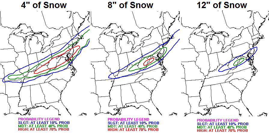
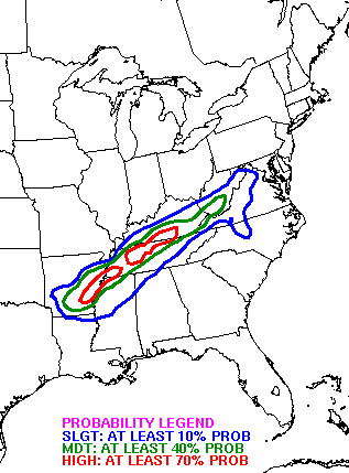
Here’s the risk area for, at least, .25″ of ice…
Throw in gusty winds of 35mph and temps dropping through the teens and this has nasty written all over it. I will check out the latest computer models as they arrive over the next few hours and send out a fresh call a little after midnight.
Take care.

Thanks Chris glad your feeling better
Chris,
I’m originally from Eastern My, and I’ve noticed in the past its very rare to get freezing rain in the mountains. More often than not it tends to be sleet and transition to snow. Do you think the mountains create unique atmospheric conditions which do not allow for very shallow cold air at the surface?
Really can’t believe it has been two years. That was an incredible / scary day to say the least.
I have a feeling this March 2nd will be interesting too, nothing of the tornado outbreak caliber, but something widespread and dangerous for sure.
2nd-3rd
Watch tomorrow’s model runs make a northwest jog, that’s just something I have always seen, though I could be wrong. (Hopefully) I really hope this storm pans out, I would like at least one good snow before winter’s over.
Take a look at the short-term models that will run an hour by hour analysis. I like the Rapid Refresh model. But, like the NAM and GFS, if you don’t read it right or know what to look for, you’ll get the same skewed amounts.
As far as the 18z run of the NAM goes, I have Louisville with 2-4″ snow with at least 0.2″ ice and 0.3 – 0.5″ sleet.
Lexington is hard to forecast because a band of heavy snow is expected to develop somewhere in central or northern KY from Louisville to E’town and Cincinnati to Richmond, somewhere in that geometric shape. Right now, ice accumulations of at least 0.2″ ice with 0.3″ sleet and 1-3″ snow.
Bowling Green will not get that 12″ snow. A lot of sleet and or freezing rain will be ongoing. However, up to 3″ could be possible. But, ice accumulation could be at least 0.5″.
I would consider these numbers to be conservative, not exuberant.
I’m looking forward to the RAP model soon.
Nope, Realist cursed us by a bet with the devil. Ice will be a main player! Not sure if I am joking or not….
No offense Realist, since I did not expect it either.
Going to summarize what John Belski is saying. His latest thinking is for southern Indiana and north central Kentucky as far as ice goes .25-.50 ice accumulations is expected locally. This will probably top the ice storm north central Kentucky had earlier this winter that resulted in over 34,000 homes in Louisville losing power. So be prepared for possible power outages by late tomorrow afternoon. South of Etown over a half inch of ice is expected with widespread power outages. A few spots may get up to an inch. Lots of moisture with this system. The last time we had such a high ice and snow risk with the same storm was the big ice storm of 2009. This will not be as bad, but it will be bad enough. Snow amounts widespread 4-7 inch amounts. There is a potential for a band of heavy snow to develop along the I-64 corridor. This is the same thing the WPC is seeing. A band of over 8 inches of snow may develop. This will have to be watched during the storm to see if it develops. If you live in rural area, be prepared to be snowed in for a couple of days. This could also happen in some local neighborhoods. With the layer of freezing rain then sleet under the snow, it will be hard to clear the roads. Following the storm, lows Monday night will drop into the single digits. The coldest ever in Louisville during March was -1. There is a chance record could be broken.
Let us hope CB’s is correct, since his current info implies less ice. For now.
That said, I agree with JBs thinking, but hoping the additional moisture draws up the moisture enough to allow warm air to reduce the ice factor a little.
Even if the moisture draws up the warm air the artic air at the surface will dominate cold artic air is very dense. I just dont see the warm air have a chance this go around the temps just north of Kentucky are dropping and quick.
Dodger says get the shovels ready! Gonna be an old-fashioned snow blitz across the northern third of KY! My backyard is ready for it. Dodger!
^ Still despicable!!
loL
Dodger says thank you!
Does anyone have a guess on the timing of the storm? Should we all grab our bread and milk tonight?
Who started this whole bread and milk thing anyway?!? It’s completely overrated. lol
The need to get bread and milk is rooted in our primal survival instinct, and yes I also make the bread and milk run prior to a big storm.
my bad
All on one person that got ejected. That is now two losses caused by friendly fire.
Play to win, not for the grin on ESPN!
moisture fetch coming from the south on radar looks incredible
The front is about 50 to 60 miles north of Louisville. This storm is going to be NASTY!
Actually think front is south of that. The cold air is lagging behind. Currently 35 in Columbus indiana
I’m not looking too bad right about now, am I?
Sorry Billy, no comparison. . .
0z NAM is even further south
Not really sure Im buying the 0z nam it looks disoriented precip wise.
Being that said I think the artic air is going to be here quicker than originally thought.
Yep. Much quicker
What is your take CB, is this a mainly ice event or snow? Might end up being a mega chunga sleet event perhaps?
show us…lol
Thanks Chris. Hope the snow is more and the ice is less. Glad UIU are feeling better. And I know those folks in Menifee County were glad you came! They know who is tre best around. Get some Allen my friend. I feel like you are going to need it. Have a safe evening everyone and get prepared!
OK, what’s up with your username? It’s always been coffeady and switched to coffeelady, to coffeady. ???
Preliminary look at RAP 23z run at hour 18 or about noon tomorrow. Louisville could be looking at possible freezing rain by then (perhaps as early as 10am, though).
Yup it wouldn’t surprise me to see no cold rain and just starts as freezing rain and goes from there.
Now if this starts off as freezing rain question is does this increase ice totals or will precip go to sleet and snow quicker? Is the NAM and GFS along with the other models acknowledging the artic air being here quicker than originally thought?
Mike, go away…you are a buzz kill tonight, lol.
It would be funny if indiana got snow tonight and then Tennessee got tomorrow’s snow. There would be no denying the fence then. It really wouldn’t be that funny
Thanks CB for keeping up to date on this upcoming winter storm. Yes, hard to believe it’s been two years since the 2012 twisters. I know you were deeply concerned for your family in Salyersville, glad they turned out ok.
I had a similar scare April 27 2011. The huge Ringgold Georgia tornado then approached Cleveland TN, near where my parents live (and where I spent my teen years). I was in Nashville desperately trying to contact my folks but even cell service was down. After several really scary hours, I was so relieved they were safe.
This is a Louisville centric post. The maps posted show Louisville isn’t even in a 10% chance for .25 inches of ice, yet the local stations all continue to talk about icing between .25 and .5 inches. Why the disconnect?
This actually reminds me of the ice storm we had on February 4. For three days, the models showed an ice storm, yet the local media almost totally down played the possibility until early Tuesday.
It seems to me, we’re seeing something similar this time. They’re touting ice when the models suggest snow whereas last time they touted a lot of rain when the models suggested a lot of ice.
I think you are spot on. I am wondering if we are in the sweet spot for major snow. I think it my be just south of here 30 to 40 miles. It is going to be close but I see more sleet/ snow then ice
I really don’t know about us here in Louisville. Might get a couple inches of snow with .25 inch of ice. Might get 8 inches of snow with very little ice. South of Louisville looks to get the worst of this storm. At least it looks that way right now.
Hey Robbie! The map he posted is actually the day 2 (monday AM) ice graphic. Day 1 is the relevant period for Louisville (Sunday morning/afternoon). Louisville’s currently at the heart of a moderate risk (40% chance) of seeing >.25″ of ice tomorrow, so not quite the disconnect that you pointed out:
http://www.hpc.ncep.noaa.gov/wwd/day1_pice_gt_25.gif
Hard to believe that about a year ago, I experienced a rare treat with my very first trip to the Caribbean (Cayman Islands). Even the sunburn was worth it 😉 !
Oh, how I wish I was back now 🙁 .
I wanted the Caribbean because back in early 2010 some friends of mine vacationed in Florida. But that was the winter that suburbs of Orlando saw snow flurries and even the lizards were falling out of the palm trees because it was so persistantly cold in Florida. So I was leaving no chances 😛 .
Robbie, models are a tool that helps mets with there forecast however there is a science to weather not all mets will 100% agree with models unless your name is Henry and your employed at Accuweather.
NWS Jackson “toying” with the idea of adding rest of SE Ky. to warning because they say .10 inch of ice and 1 – 3 inches snow – while WPC puts the exact same area in the worst smackdown for ice! Wow
and just earlier they removed us from the watch because we were only getting .2 of ice and an inch of snow lol
March is definitely roaring like a lion with this weather event!
I need some rest, I wonder what I’ll be waking up with tomorrow morning’s forecast? Farther south track? Sleet event? Big time snow thumping?
Things are really starting to look bad Sunday afternoon into Monday, ice maybe a big time problem for southern Kentucky!! WalMart was packed today!!
1st of the month
You would know.
Yeah i can read a calander
Have a feeling I’ll being living like Laura Ingalls from “Little House on the Prairie”. Living without power sucks 🙂
…just give a holler for Mr. Edwards- he always saved the day.
At least the weather was nice today. Gave me a chance to get prepared for power outages. Most people don’t think to do this but, if power goes out, you can take food from your deep freezer,,etc and put it in coolers outside and fill them up with snow. Will keep it frozen and you won’t lose all of your food. I’m stocked and ready to go….just hope I won’t need it. 😉
Most March storms I remember tend to be real nasty and lay a real smack down on some one who that will be is yet to be decided. If this baby tracks a bit father South look out central,South central and Eastern KY it’s hammer time. Though I’m not a weatherman I am staying in a Holiday Inn Express tonight. Everyone have a great night and buckle up