UPDATE
The NAM just made a new friend in the European Model. That latest Euro comes in with a colder and farther south solution which is more of a heavy snow threat to many. I want to caution you that the map below has a history if inflating snow totals. It basically shows ALL frozen forms of precipitation as snowfall, so don’t just look at the numbers…
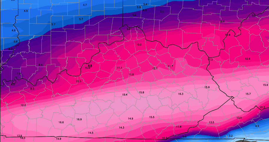
If you look more at the placement, it matches up with what the NAM was showing with this morning’s run. Again… don’t worry about the numbers it’s showing. It’s taking sleet and freezing rain totals and adding that to the snow forecast.
Take care.
Previous Update
Good Saturday afternoon, everyone. A major winter storm will slam the bluegrass state Sunday into Monday. This will likely create many problems and could result in power issues before all is said and done for some. I have a breakdown of how this looks to play out an the infamous First Call.
I’ve seen the various forecast models and the NAM looks to be an outlier with what it’s showing. That doesn’t mean it can’t end up correct, but I don’t like models that don’t play well with others. 🙂
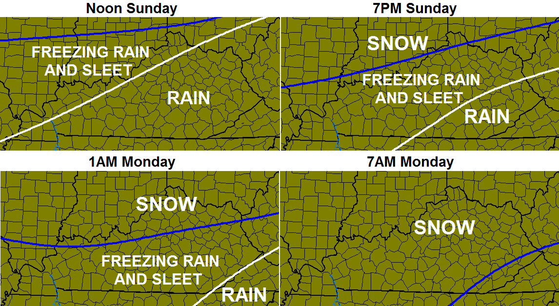
A nasty mix of rain, sleet, freezing rain and snow will impact the region starting Sunday morning with the frozen precipitation taking over from northwest to southeast late Sunday into Sunday night. Timing and placement of each type of precipitation is crucial to how much of each you get outside your door.
Here’s a rough estimate of how this takes place…
Putting together a first call map is tough to do with so many precipitation types at play. If one of the types remains more dominate than the others, it totally throws everything out the window. I am VERY confident of this winter storm impacting the state. I am not that confident in the placement of totals. Regardless, here ya go…
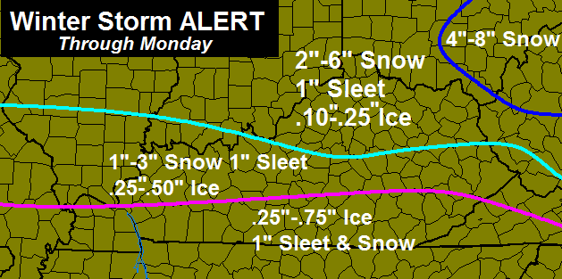
That WILL change as things become more clear and I will update accordingly. If the NAM is right… that whole map gets thrown out the window.
Gusty winds of 30mph and temps dropping into the teens will be with us Sunday night into Monday. Those will just add to the nastiness of this storm.
This storm comes on the two year anniversary of the historic tornado outbreak that hit Kentucky. I will be at a special ceremony today at 5 at the Menifee County High School to talk about that tragic event. Come by and say hi if you’re in the area.
With me being on the road… I will be sending out updates via Twitter and won’t be able to update this blog until later this evening.
Enjoy today’s nice weather and take care.

this will cripple S/SE if we get .75 ice
Yes it will Rolo. I was surprised to see the high totals for southern KY. I hope it doesn’t verify.
Just what I was thinking Rolo. I’d say definitely no power for who knows how long. (If this comes about).
HUGE IF
You and I know that if the forecast is ice, it rarely misses. Still, I like the defiance 🙂
still betting on plain rain and as long as its not fire i dun care to much anymore this season
Thank you CB. Just try to take it easy a bit and have confidence in your team. You need a rest!! Take care.
Thanks Chris
The 18z runs will be interesting
Thanks for the update Chris our maps seem pretty similar. The sleet and ice could turn out to be a big deal in my neck of the woods..
Where are you Ryan?
Pikeville
Hi Ryan, congrats on getting accepted at Mississippi State’s wx program! I’m a WKU grad (and my wife is Murray State grad), but I only took biology and geology, no meteorology at WKU. Now a SkyWarn storm spotter here in Nashville TN where we may be about to get clocked by ice.
About two years ago, you likely know too well the West Liberty and Salyersville twisters tracked just to your north. Obviously big differences in wx now and two years ago 😉 .
So much for tornadoes not occuring in rough topography.
Maybe a major ice storm for Somerset and London area, that is not good at all!
Thanks Chris…hope you are feeling better…..save travels this afternoon! I think it might be a good day to make my bread and milk run 🙂
Thanks Chris. Do not like the idea of ice so I am hoping the first call map gets better. Don’t want ice for anyone. Will be watching twitter and the blog for updates. Enjoy the afternoon everyone.
Dodger thinks this might be a home run for his backyard! Nothing like some frz rain, sleet and then snow topped! Hope everyone gets what they want. Dodger!
u ALwayz be speekin in da 3rd PersoN sayin Dodga dis Dodga dat but aint ya name is Rodger and you in Dodga?Dudnt rely make much senSe eithA way.At leest you is a postive person just dont get da namE thang.
lol! Insert the old pot and kettle cliche here!
BiG SNoT thank it gunna SnOw big big snow 4 BiG SNoT BiG SNoT hear dat iT gunna be bad wether BiG SNoT luv da bad wether.BiG SNoT!
See wHat i meen?N SorRy but I dont be doozing drugs.
Anyone recall how much ice central ky got in the Jan. 2009 ice storm?
Surprised by the ice totals of central ky and south. Hope it is not even close to verifying with the snow that might come on top.
Around a inch of freezing rain fell in 2009. Maybe a tad bit more
Thanks. Was thinking it was 3/4 to inch here in mercer county. Just remembering watching it all day long, seemed it would never stop.
And about three inches of snow on top. That was the final Allstate Mayhem touch that made everything collapse and break.
That is why this forecast has hit me with déjàvu. The snow on that ice was the deal breaker. Remember watching and listening to trees snap for hours, like everyone else who went through it. This forecast has a little less freezing rain, more sleet does it not?
Depends on where your are when the fence settles. The more North of it, less ice. I have no clue where the fence will settle.
Could be multiple fences the way things are trending!
What does he mean by the nam? more snow?
Yes and ice gets pushed south somewhat
Think so. Check a couple of earlier posts and i think he had one of the nam runs up which was heavy on the snow side of precipitation.
Yes it showed quite a bit more snow and more of it south
The NAM ran the heaviest snow on the south side of I-64. Those totals were as high as ten inches for some folk. The NAM could do that because it thinks the temperatures at mid levels of the atmosphere will be colder than the other models…hence, the snow falls all the way to the ground instead of melting as it falls. Sometimes a weaker storm allows for the cold to be further south whereas a stronger storm pulls warm air further north. The computers still don’t know everything about atmospheric physics.
Thanks for the insight Tom. Chris and the other people on this blog are amazing.
So last night the Canadian was the outlier does that mean its in line with the GFS now?
No weather balloons needed. This storm is going to be big time.
I have a feeling the comments section will explode this afternoon. Not looking forward to ice. More prepared than in Jan 2009 though.
And just when I was hoping that spring was knocking on the door. And just when I thought I had made it through a winter without losing power for a week or so. Stay safe everyone!
Thank you Chris for working so hard to keep us updated so we can be safe.
Thanks Chris you are amazing even when you are sick you are out doing for your community.This Storm looks like it means business.I hope no one gets that much Ice.Will be watching for your updates Chris.
Hopefully the southern trend continues and that NAM is right, it’s hard to see the models trending south continuously. At this point, any northward trend would bring more ice. This afternoon and tonight’s runs should definitely hold a better forecast because for the storm coming onshore.
Just thought I’d post this… NAM 12Z+60 if this plays out, this will be talked about for years. Enjoy!
http://www.twisterdata.com/index.php?prog=forecast&model=NAM&grid=221&model_yyyy=2014&model_mm=03&model_dd=01&model_init_hh=12&fhour=60¶meter=SNOWIN&level=SURFACE&unit=none&maximize=n&mode=singlemap&sounding=n&output=image&view=large&archive=false
Boo to ice!
The 00z runs of the models this evening should start to get a good handle on the storm.
I am from Murray, Ky and our forecast here is for and half inch of ice and 3 to 6 inches of snow as of now
For what it’s worth the weather channel just showed a 8-12 inch band of snow for frankfort north to Cinnicinatti area??
Is there a certain model thats relied upon once we get 24-48 hours to the event?
A lot of people start to look toward the RUC, RAP and the hi-res models (hi-res nam, HRRR).
No model is completely reliable no matter how far or close. BUT there are some that are more reliable than others.
No. On a storm like this the models will be forgotten/ignored once the storm begins and we’ll start tracking actual temps and type of precip to see what is actually happening versus what is being forecast. The models really struggle with the rain/ice/snow lines because it does only takes a difference of one degree to ruin the model. However, the models are very good fifty miles north and south of the demarcation line. And, last, the models are very good everywhere with predicting the total amount of precip…it’s how that precip falls (rain, ice, or snow) that is the problem.
Thanks for the info!
I hope this storm ends up being a big bust. Too many possibilities for ice – no one wants that.
Any idea which model has been the most reliable this year?
Weather channel has 8-12 inches for us here in greenup…most of Kentucky is under power outages likely
Saw sheer the entire state is red lined with likely power outages too. Hoping for more snow at this point. Maybe will be if trending colder.
The, not sheer. Ugh. Autocorrect gets me every time.
I haven’t seen it linked yet, but everyone should take a look at DT’s Facebook page. He’s got much of the state with 9 inches and a good portion with 12 inches plus.
He doesn’t even mention sleet and/or ice. He’s made the point the major models have all trended much colder and further south over the last 24 hours.
I know the local guys will suggest the totals on the models are overdone because they’re not factoring in sleet and ice.
Who is DT?
He runs the WxRisk.com Facebook page. He has a good track record on his forecasts. I trust him just as much as I do CB.
12 inches plus for a swath of central ky. Thanks for the site info guys.
http://www.facebook.com/WxRisk
Link
Thanks!
Just a warning to anybody that is not familiar with him, he doesn’t care to tell you like it is and usually openly blasts anyone that he considers “an idiot”. He usually adds in a few four letter words too lol.
So he is a twelve year old that also talks smack when playing Call of Duty?
no that would be the 35+ folks that play COD lol
WINTER STORM WARNING for central and southern KY and west. This includes Lexington, Louisville, Frankfort, E-town, Bowling Green, etc. WSW’s go all the way to the Tennessee border.
We still have SWS here in knox county.
here’s a snowmap from wxrisk.com
http://www.americanwx.com/bb/uploads/monthly_03_2014/post-534-0-03559000-1393699702.jpg
Wow, that would be one or the books if it came to fruition.
This storm just has a different feel to it
Forecast sucks! I just hope we don’t lose power in Eastern Kentucky. But on the bright side I may not make it to my dental appointment Monday. I’m Scheduled for a wisdom tooth extraction and I’m dreading that like a tooth ache..haha I’m so funny 🙂 well, not really. Stay safe boys and girls
No Barb, this is a great forecast. Lots of snow, hopefully litlle ice. Great way to close out winter and move on to spring and summer.
Euro and nam decides to be friends!
Let’s see if the 18z GFS decides to join the party and become friends with the NAM and ECMWF.
Well, looks like the largest snow of the season might come in March. That is not surprising as that happened in 2008 and 2012. As far as seasonal totals go, here is what is needed.
Louisville needs 1.5 inches of snow to have the snowiest season since 1997-1998. 6.5 inches would make this the snowiest season since 1977-1978.
Lexington needs 8 inches to make this the snowiest winter season since 1993-1994. It would take 12-13 inches to make it the snowiest season since 1977-1978.
Chris, may I ask what it is looking like for Anderson and Mercer?
I would say a good amount of ice and snow. Hope for the models to come in colder–right now we look to be in a zone of 1/2 inch of ice with 3-6 inches of snow.
I sure hope the ice stays away. Thank you Chris .
Old man winter just might be going out with a bang, hopefully not to many power outages, unless a epic bust happens, this might just be the Old Schooler Rolo likes to talk about, atleast in some areas, all we can do is wait and see now, the stage has been set!
Don’t curse us with Rolo talk.
They put us southern counties in the watch, took us out, now we’re back in? Very confusing for some people. Thank you Chris!!
When are the next model runs updating?
Don’t feel too bad. Here in NKY/Cincy we are still just under a watch. This has been the craziest storm. First Cincy is the bullseye for a significant ice storm. Then we weren’t. Now a bit of ice is back in the mix. I’ve seen anything from 1-2 inches of snow to 8 inches for us.It’s a wait and see game I guess.
Stay safe everyone. Hope all of you don’t get any ice and just plenty of snow.
Winter Storm Warnings now extended into Eastern KY.
OK. There was a method to my madness by posting that we were still under a watch. Just looked at NWS Wilmington and low and behold we are now under a Warning. Need to go back and read the text. Hopefully they have a better handle on it.
OH GOOD…..That 15 inches includes sleet, freezing rain and snow….Whew!! Thought we were in trouble for a minute :O
Ha!
This weekend is the 17th anniversary of the floods in Cynthiana and Falmouth.
So, Where is Lexington sitting currently as far as ice? I don’t really mind the snow. Thanks guys
The WPC has MODERATE RISK FOR 8″+ OF SNOW IN CKY INCLUDING LEXINGTON, FRANKFORT!!! And east through Washington, D.C. and New Jersey. Sorry for all caps, but it seems the heaviest snow axis is setting up through central ky! This has me a bit excited.
http://www.hpc.ncep.noaa.gov/wwd/day2_psnow_gt_08.gif
Does that mean less ice and more snow? Thanks
Holy snow batman!
Doesn’t look like bell and Harlan are gonna be seeing anything much except rain..
Well guess it’s time to make the ole bread and milk run..Eastern Ky may get the worse of this for ice before changing over to snow..
GFS seems to be more realistic at this point. Latest 18z NAM is way to aggressive on the snow totals IMO. I’m betting on more sleet than freezing rain. 925mb temps are getting colder with each update. Any agreement / disagreements are welcome.
I think you are right on target with this. If the GFS is right, more sleet than freezing rain. If the trend keeps coming in colder, perhaps mostly a sleet/snow storm and less freezing rain.
Ryan’s forecast looks good, since considers the stunting factor of non snow frozen stuff.
Are you talking about the 12z GFS or the 18z GFS (if it’s out yet.)
So are you saying, more south ( Somerset area).?
I took a nap, woke up just now, and went to the NOAA and this blog.
O ……M……G
I have mixed feelings about this. I have wanted a big snow for a long time, but I’m sick of snow……..but admittedly, if it’s going to be a big snow, I’m kind of excited now………I hope the ice for everyone is minimal. I can’t believe someone made an absolute statement a week ago saying “the northwest trend WILL happen”……I can’t remember the person who said that. LOL
It was me! Trends are trends and there is still an outside chance of the NW shift. I am hoping not though.
This is a rare event for KY, a arctic front crashing into heavy moisture in KY at the same time, this might be a huge event, even the NWS is now saying heavy banding snow might develop in spots and put much more snow than currently forecast, as always, we shall see??
The question is: why is this so rare?
It didn’t used to be.
I really hope that everyone can stop using 1998 as a reference of the last “big” snow.
So what are the snowtotals looking like for Franklin County? DT says 9″ or so but what I see here is more like 2-6″! Sooo confused
meanwhile in Southern California, a tornado warning has just been issued north of downtown Los Angeles near Glendale and Burbank.
Sharknado!
LOL! 😀
Still holding out in fence in the ohio river. 90% of ky gets rain. Lol. I hope I am wrong and the above maps are right
90% of KY will get rain at first, then 100% turns into something frozen 😉
For that to happen, the storm would have to jog 100-200 miles north, that’s not happening.
Sleet should cut into totals, but better than ice and heavy snow to avoid power issues. If ice grabs hold, this would get sucky real quick. Ditto for heavy snow above six inches with ice acting as super stickem. Nasty stuff, so counting on sleet. It is our frozen friend.
Nothing to see here folks…move along 😉
Long time reader, few time blogger….
Just added another coating of snow. Ice and sleet spray to Madison Counties dome…. All areas around us should receive perception to we will remain wintry free… 🙂
Okay, spell check… Sentence check time… As instead of to…
I have updated snow/ice/sleet maps on my blog if anyone wants to see that click my name.
I’m seriously anxious to see the 18z suite. If that LP keeps being forecasted as south as it is now, this will be a significant storm for many in Ky!
great page thanks
I like your map layouts.
Thank you for extending your coverage to west of I-65.
Seems reasonable forecast. Hope the ice part is wrong, but more likely it will not be.
Great site! Thanks for sharing it.
Thanks guys!
Here are the WPC snow/ice maps
Day 2 snowfall greater than 4 inches http://www.hpc.ncep.noaa.gov/wwd/day2_psnow_gt_04.gif
Day 2 snowfall greater than 12 inches http://www.hpc.ncep.noaa.gov/wwd/day2_psnow_gt_12.gif
Day 1 ice great than .25 inches http://www.hpc.ncep.noaa.gov/wwd/day1_pice_gt_25.gif
Day 2 ice greater than .25 inches http://www.hpc.ncep.noaa.gov/wwd/day2_pice_gt_25.gif
How much snow will it take to call it a dome buster?
Not sure, maybe 8″+? Long time ky residents, how much do we need for this to be called a dome buster?
8″ or greater.
Looks like Hardin countys gonna get slammed. And me surrounded with 20 acres of trees lol. Fun times.
So glad we have 2 wood stoves, 2 fireplaces and a gas stove.
Ice is a bummer, but throw snow on top of it, many would need a fireplace and gas stove.
We’ve brought in some more wood for the stove and gas for the generator. TWC has Central KY getting slammed by an ice storm then 5-8 inches of snow. Everyone stay safe and warm! Thanks, Chris, for all your hard work!
Is there some sort of winter storm coming???
Heard someone say we’s gonna get 2 foot of tornadoes and a snow front tonight. 😉
Naw, just some light flurries accumulating to 12″+. You’ll be ok. 😀
The 18z NAM just came out recently and keeps the southern track with the southern half of KY getting slammed!
http://wxcaster.com/archived-snow-overlays.php3?STATIONID=LVX&basetime=201430118Z&model=NAM
That’s a wild map, taken literally, it would mean 2″ of snow for far southern Laurel County, near Corbin, and upwards of 8-10″ of snow for the northern half of Laurel.
18z NAM is consistent with 12z — Colder and snowier for CKY/EKY
Nice to have a backup while Chris is tied up. Nice site.
The way the Kitty Cats are playing right now, we might not get the kinder gentler CB this evening.
Amen to that. Not to sure I even want to watch the 2nd half.
Cats looking like that are ready to watch march madness, because they might not be playing in it, AGAIN!
great talent, bad team. first round out in the NCAA’s this year. but at least they’ll get to go…for one game. 6/7 seed does not impress.
So I’m a little late to the party, have been busy and haven’t been able to keep up with this, is the storm coming from what California and Arizona are getting now while merging from front dropping down from north? Seems like the moisture is a long ways off to happen early or even by evening tomorrow.
Never thought I’d say this about a snowstorm but I really hope it trends north a bit. Daviess County would love a foot of snow! 😀
Still think there will be a shift to the north nothing extreme gut feeling tells me that the heaviest snow will be the North Central Ky either way its gonna get nasty statewide. By this time tomorrow it will be real interesting to see who is getting what falling from the sky.
Trend to date supports that. The models for now do not, but not their not exactly a reliable source for winter events for KY.
Too many nots, but perhaps fitting.
If the Cats lose, we get more ice in central KY…if they win, a HUGE snowstorm. C’mon blue…
Ruh roh.
It’s all your fault for the ice, so thanks 😉
Cat’s starting to look un-Danceable and an ice storm. Arkansas fans are ticked of too, since gives their sweep a lot less weight.
Cats been licking antifreeze in the driveway??
I don’t know, but they are getting close to the bubble. They lose the next two and get knocked out first game in SEC, they are probably out.
Agree
my fault. Lexington will be punished. these kids will be pooping ice, not ice cream tomorrow.
Dodger officially predicts a track a little further north before all is said and done. It just wouldn’t be winter in these parts unless it went the opposite of south! Regardless, somebody gonna get a white hammer! Dodger!
Here’s some eye candy: This comes from the latest WRF… Look at the 2 feet + zone in west ky!
Click HERE for eye candy
Wow lol looks like 18
Inches here in NE KY! Doubt that will happen tho lol
Eye candy typically never comes to fruition, or hasn’t in the past, but if yours does you will be an instant legend.
A lot of that is ZR/Sleet but it’s interesting to say the least!
Yea, unfortunately the WPC still has southern KY and parts of TN (including here in Nashville) really under the gun for ice. The better half (wife) and I are planning accordingly 🙁 .
Ryan, perhaps you missed my earlier posts further up this thread, but congrats on going to Mississippi State for wx 🙂 Also, glad the March 2 2012 tornadoes stayed north of you.
I did miss it. Thank you! I’m very excited for the wx program at Mississippi State!
I’m very thankful that the storms missed us just to the north, we were very worried that night.
Yea, you likely have learned (or soon will) that rising terrain tends to hinder tornado genesis a bit in that this terrain lowers dewpoints and raises Lift Condensation Levels near the ground. Since many storms go roughly from southwest to northeast, your area is in a bit of a tornado drought shadow due to the effect of the Tennnessee Platuau and then the mountains of southeastern KY including Black Mountain.
Unfortunately, the 2012 storms moved almost directly west to east so strong tornadoes were possible even in far east KY.
Back in 1944, West Virginia had by far its worst tornado outbreak that even went deep into the mountains. These storms got their tornadic energy in Ohio/Indiana and then moved in a rare southeasterly direction.
Is that snow and sleet accumulation or just snow?
What about the 18z GFS?
On board with NAM as far as track goes, less moisture.
Does that mean less snow for morgan co?
http://www.twisterdata.com/index.php?prog=forecast&model=GFS&grid=3&model_yyyy=2014&model_mm=03&model_dd=01&model_init_hh=18&fhour=48¶meter=SNOWIN&level=SURFACE&unit=none&maximize=n&mode=singlemap&sounding=n&output=image&view=large&archive=false
Artic front is draped from Indy to southern Illinois so its on the move. Now as the first wave of precip moves through the area it will help the artic front progress quicker and pick up more speed.
I have a feeling all CB is seeing right now is cold-cold ice rain. Even in Hawaii.
Conservative Andy Weingarten from Wave3 in Louisville is forecasting .25-.50 of freezing rain and sleet and snowfall amounts of 4-6 inches of snow. Rain at 10am, freezing rain at 1pm, sleet at 4pm, and snow by 7pm.
He also said 8″ isolated spots possible in Louisville Metro, as well.
Ya’ll remember to keep your roofs on not in.
http://www.facebook.com/severeweatherEU/photos/a.1423656947857402.1073741825.1377757209114043/1476432645913165/?type=1
Hey Chris, could u plz put Nicholas County, WV back on your prediction maps??? I have followed your blogs since WSAZ and still do! The last few storms though, Nicholas County has been cut off :-(. Keep up the good work and move your maps just a little further east PLZ!!!!
So glad I went ahead and watched the 2nd half. 🙁