Good Monday afternoon, gang. It is Monday… isn’t it? With the crazy weather, it’s easy to lose track of the days. Our winter storm is winding down across southern and eastern Kentucky this afternoon. It’s leaving behind the most widespread snow and ice of the season and now comes the bitter cold.
Roads will continue to be snow and ice covered through the day and it may not be until late Tuesday or Wednesday before many of them improve. Temps this afternoon will struggle to get out of the teens with gusty winds making it feel much colder.
Readings tonight will drop into the single digits. The NAM numbers…
 There’s a chance for temps to tumble even more than the models are showing. I would not be surprised to see some areas approach 0 before all is said and done.
Looking toward the later part of the week, we find a storm coming out of the Gulf and riding up the east coast…
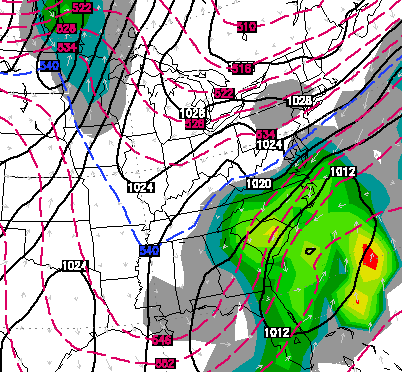
It would not take very much correction of the models to bring that farther west into the bluegrass state. Here’s hoping that is not the case and that bad boy stays well to our east.
Temps will moderate, but this is going to be a colder than normal March. Have we seen the last of the snow? Probably not.
Thanks for all the snow and weather reports over the past few days. You guys rock. On a related note… I am a happy camper with how the forecast worked out. Dealing with all 4 precipitation types is a challenge, but I feel good about how things played out. Shew! 😉
Take care.

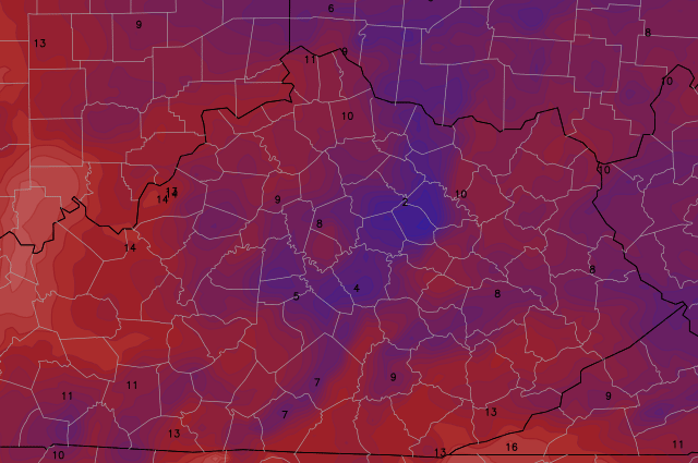
6 inches on the ground and still snowing in Northeast Pike County.
I love winter but I’m ready for spring.
Had my eye on that storm coming out of the gulf for a while. It will be very interesting to see what comes of it.
Nearing 6″ here in Pikeville!
2 inches of sleet covered by 4 inches of snow in northern Pulaski
You sure have done well this winter. We have at least 6 inches just off rt 1274, near Long Bow boat dock.
Chris you are the best at what you do you was right on it for morgan co we got between 7 or 8 inches maybe a little more I know it’s a good on
Chris spot on again still snowing in Pikeville.
Thanks for all you do! We have abt 6 inches here so that puts us at 37 inches of snow this winter!!!!!!!
Four and a half inches in Russell KY (Greenup Co.).
Hard to tell as it drifted fairly badly, so I measured in five areas and averaged it, lol. Didn’t know how to do it otherwise.
spot on forecast for my area Bailey. be careful if you absolutely MUST travel over the next few days, folks. 75 at Clays Ferry is still slow and Old Richmond has not been plowed. it would not surprise me if many schools cancelled tomorrow.
Thanks, Chris. We had almost two inches of freezing rain and sleet, but we got in on the snow action this morning and picked up probably two or three inches on top of the ice. It has just now stopped snowing here in Somerset, andit is absolutely beautiful outside! From all the freezing rain and wind last night before the changeover to sleet, our back door garage door was frozen shut this morning.
We still have a few flurries flying around, but I think our snow is over for the most part. I have to say, it has been absolutely beautiful! I know a ot of you are sick and tired of the snow, but this is really the only one we have gotten in my neck of the woods, so I am enjying it, even though I am now moving into the spring camp with everyone else.
Everyone have a great, safe afternoon. Thanks Chris for all you do. You are the best there is!
Congrats on your snow Coffeelady you deserve the snow more than anybody.
Yay! I’m happy for you. And you are right. It’s a beautiful snow!
Happy for you! We have a good dusting here and the roads are in fair shape, maybe snow cream next year? 30 miles makes the all difference!
That is great Coffee so glad for you.
It only took half the day today but heavy snow FINALLY got here but it didn’t last long. Glad this was a bust on wind and ice totals.
I don’t know how many inches of snow we have, but it’s deep. It’s still snowing pretty hard.
You did great with the forecast. We are looking at 6 inches of snow in Carter co. We had sleet and thankfully not too much freezing rain. Thanks for all you do for us. You ARE appreciated.
Thank you for all your hard work Chris. You were right on again!
An inch or so of sleet and 2-3 inches of snow in Jtown. The sleet that went on for hours lowered our snow totals for sure. Thanks Chris!!!!!
Good job Chris, you had frankfort in the 2-5 zone and we got about 4 inches or so, the sleet held down our totals some here or this would have been frankforts biggest this year, anyway 26-28 inches for the winter is not bad!
Now im officially ready for spring 🙂
A good four inches here in Lexington. It is a really pretty and even cover. Here’s hoping the sun stays behind the clouds until tomorrow. Let the world stay snow covered for an afternoon, Mr. Sunshine.
Got about 5 inches of snow in South Lexington. The biggest snow I’ve had all season! Also the biggest snow I have ever had in my entire life! Love it!!! I used to live in Florida my whole life, and this is my second winter in ky.
Yea – this is (at least to me) on par or a little better than the 4 inch snow we had in Feb that stayed on the ground for 2 weeks…..Only this time the roads are worse because the temps are in the teens.
Does anyone know what the official total for Lexington is? I only have one way of finding it and that’s in the climate info that seems to be updated everyday but not until 4 (ish) pm or so
5.0 through 1:00 P.M. today.
That snow you’re talking about last month missed us in S Lex, only 2″ fell and 1″ on southern tip. North got hit with 4 and near 5″. Glad this storm made up for it, now it seemed like the south got hit a little harder than the north.
We got between 4″ and 6″ of snow in South Lexington depending on which part of our yard you measure. The roads in our subdivision are very icy right now and I am wondering if FCPS will have another snow day tomorrow just because the city can’t get to all the roads before then. But, our trees only have the lightest coating of ice and we never feared losing power.
I’m pretty sure FCPS will call off schools tomorrow. I’m out on the roads and the highway/main roads are getting a lot better by the second because the sun has now come out. But the less traveled/neighborhood roads are terrible!
Snow looks all but find here in Carrie of knott county measured just shy of 3 inches balmy 22 degrees
All but done, darn smart phones
Through 1 PM official storm total for Lexington was 5.0 inches (0.4 yesterday, 4.6 today). That’s right in the low to mid range of what was forecasted. Seasonal snowfall is now at 24.3. Need 3.5 inches to make this the snowiest winter since 1995-1996, and 3.8 to tie 1993-1994. Still 17.8 inches behind 1977-1978 (the next on the list)
Thanks Chris (Mercer)
It must have snowed HARD this morning while I was asleep. I didn’t get to bed until almost 5 am. I could tell looking out when I got up around noon that it was deeper.
A heavy band of snow started in Lawrenceburg about 7:00 and lasted until 8:30. It added about 2 inches at my house during that time.
During my nowcast, I used the RAP short term model and it was spitting out about 5″ for Lexington, but it was including a heavy band of snow that was supposed to develop during the wee hours this morning, not after sunrise.
Kind of like banking a 3-point shot instead of swishing it…..
Thanks for all your hard work, Chris!
London ended up with 1-2″ sleet/frz rain combo then 2-3″ snow on top of that. It’s beautiful and is awesome for sledding!!!! I guess this was our “big one.” We’ll take what we can get. Schools will likely be closed again Tuesday and possibly Wednesday in Laurel County, considering crews are having a time just clearing the sheet of ice off the main roads this afternoon. Be safe everyone!
I doubt school will be in session until at least Thursday considering the outlying roads from London are in horrible shape with at least 2 inches of sleet and ice on them not to mention the snow. Unless a quick warm up, kids enjoy the break the price will be high for all the school missed
Chris Bailey, you are the best!!!!
Great job Chris. We can always count on your forecast. We got 6 inches of snow here in Lawrence Co.
Measured 5″ everywhere I poked in my driveway here in NW LEX, so seems to match everyone else in Lexington and NWS. Nice to have consistent numbers for a change 🙂 Shoveling was nearly a workout.
Indeed it was! Heaviest snow I’ve ever shoveled in my life!
Got about 7 inches up here on the ridge in greenup! It snowed HARD for about 6 hours
This March sun is strong! My driveway is almost completely cleared off from the ice and sleet that was exposed when I shoveled this morning. I would say all the main roads will be good to go by later this afternoon.
It is very strong, main roads drying up a little. My driveway is still covered though, not quite melted yet.
Temps headed for the single numbers tonight so any water out their from todays melting will freeze solid tonight, be careful folks!
Just for kicks was looking at some long range models in about a week and half temps look to drop way below normal once again.
I’m just about ready for Spring.
Come April 1st, I want 70’s for highs and 50’s for lows. Is that asking for too much?
I also want Thunder over Louisville to be nice foe a change, lol.
Clay County ended up with 4 inches of snow, some ice on trees and about an inch of sleet. Still flurries coming down. System is almost out of Clay.
Final totals for Berea East. 3.75″ of snow and .25″ of sleet. No freezing rain. Winds never went above half of the 30mph mentioned. The last forecast was during the 11pm newscast and had 4-8″ for the entire area.
This almost reached the minimum amount forecast, but the sleet, wind, and freezing rain forecasts were off the mark for our location. I’m pleased that our dome nuked CB’s ice forecast of doom and gloom for two events in a row. Given that it managed to contain the snowfall total to slightly below or at the Nowcasted low total of 4″, I’d say the dome is still intact.
Berea winter total from Oct. to until today 16.25″.
Looks like a surprise coming for the equinox. Don’t get too confident spring lovers, #Team Snow isn’t finished yet.
Technically, it did, if your measurement is correct. Always add snow and sleet totals together for a final storm total. That’s how the ‘official’ reporting stations do it, like Louisville Int’l and Lexington.
I had 0.3″ sleet but 2.3″ snow in southwest Louisville. Therefore my storm total of snow/sleet came to 2.6″. Freezing rain is measured separately. I had only 0.1″ or less.
I measured 5 inches of snow in the backyard and 4 inches in the front, so lets call it 4.5 inches. I’d say at least a half an inch of sleet is included in that measurement. I love snow but I sure hope Ive seen the last of it this winter.
I have been really impressed with Chris’s spot on accuracy this winter! I found this site this winter. I’ve lived in NY, Nevada, Ohio and Iowa before moving to beautiful KY. I think Chris is the best in the tough and wild world of weather!
Highest wind I’ve recorded today was 7mph I too was curious about where the 30mph gusts went
Drove to work at 4am from Nicholasville to Lexington, and trust me the wind was blowing snow around like crazy and made difficult driving even more difficult.
same place the ice and snow went for SE Ky at lot less than expected thankfully
I’m not complaining at all, just curious, glad it missed
The wind was very strong and steady with near sideways snow at 4:30 AM in Richmond.
Because you slept through it doesn’t mean it missed…
15 mph was the peak far from 30
We had 7 1/2 inches of snow at Denver, ky in Johnson county
Record low for tomorrow morning in Lexington is -1 set in 1873. 141 years ago! Wonder if we can make a run at it?
For us to reach that, we’d need the winds to calm down to nothing. Winds may hold up just enough to not see and lows below zero. Forecast low for Lexington is 5°. Let’s see…
*any
Not “and”
That’s the 6th oldest of any record in Lexington. Records date back to1872! 5 records from 1872 still stand (most, if not all record cold max)
North Madison picked up 2″ more snow after I went to work, so a total of about 5″ counting everything. Good news for the day is the sun came out and helped clear a few spots. The bad news tonight is a lot of the melt will be ice and harder to see. Lack of wind during the afternoon means less drying and more puddling.
You always find a downside, don’t you?
Cautious side.
What type of winter weather would satisfy you?
Warm up soon
Roads in NW Fayette County are horrible! FCPS made a great decision after what I just saw! Wow!
Same here in south side! Only streets in the city that are mostly clear are the highways and downtown. (key word: mostly. Not all clear)
Very interesting storm in Knott county minor flooding, sleet, and 3 inches of snow all in one day.
Down to 7 degrees already at Denver, Ky in Johnson Co, I believe we may go below zero tonight.
I’ve got 11 here in Carrie, don’t feel that cold out, guess it’s the calm wind
Down to 4 degrees @ Denver, Ky in Johnson Co.
7.5″ of snow in Johnson County today. Had a coating of sleet beforehand, last night. Kudos on the forecast. 6 degrees at 11 p.m. I think 0 is definitely a possibility tonight.
Currently 9 degrees at BGA. Rare to see BGA warmer than ky mesonet site. (11 degrees)
4 degrees in Johnson County. Mesonet says -1.
Whoever said the wind wasn’t strong last night is wrong. It was gusting like crazy……my roof and walls were making popping noises from the wind…..
Peak wind gust of 15 mph is not strong sorry
Same here, though they probably have more insulation from sound in their home.