Good Tuesday, everyone. Our day is off and running on a very frigid note across the state with many areas in the single digits. Temps will warm into the upper 20s and low 30s with mostly sunny skies. The high sun angle can help thaw some of the streets and roads out today.
Wednesday will start in the teens and end in the upper 30s and low 40s. I can already see some ugly snowmen taking shape around this time.
There is a system trying to develop along the southeast coast by Thursday. That may throw some moisture into the state and that’s something for us to watch for.
After that… I see a moderating pattern taking place. This could send out temps into the 50s over the weekend. If things break our way early next week… a taste of spring may even break out.
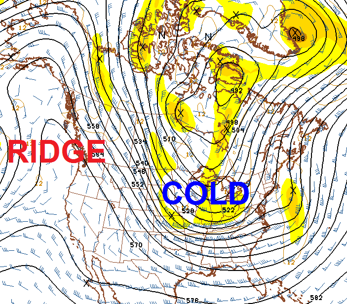
That’s the good news. The bad news is that it won’t last very long. The pattern is very likely to feature colder than normal temps returning. Take a look at the GFS Ensembles 5 Day average temperature anomaly in Celsius…
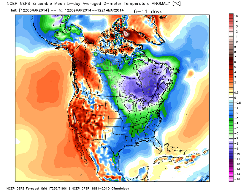
Notice how the cold deepens after the Ides Of March…
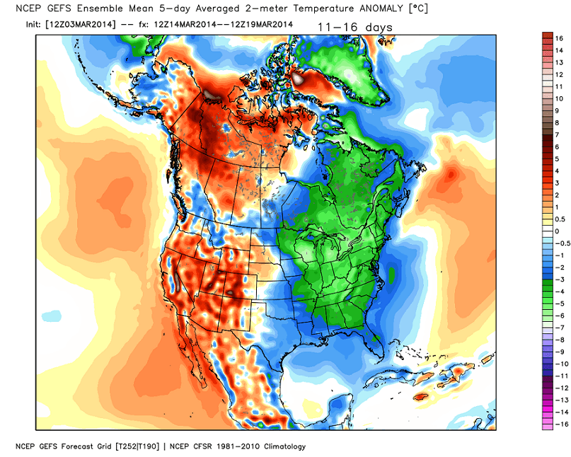
This type of pattern alignment can produce quite a bit of cold and even another shot of winter weather…
Can we still be on #teamrain or did that reverse jinx us with this last storm? 🙂
Enjoy the day and take care.

Chris it was 3 here in west liberty now it has gone up to 4
one good thing with it staying cold, it’ll keep the severe weather season at bay
.
With the way the past month or two have gone and the systems keep rolling in we will be having a very stormy and wet spring season. Severe storms will be here soon.
Yes it does
5 here in Carrie of knott county this morning
5 degrees here in Pikeville, roads are still terrible.
Nice site
#teamrain was not a jinx……we all know it was reverse psychology!
And it worked! Remember 90% of Ky will get rain.
THINK RAIN!! Unless you want rain then THINK SNOW!!
I am really ready for spring! Thanks for the update!
THINK SNOW!!
16 degrees this am at my place much warmer than most but we had almost all rain
How are the roads , Ironworks to Georgetown from 7 miles out Bryan Station ?
#Teamrain definitely worked for me. I’m gonna stay on that bandwagon.
Went down to -1 degrees at Denver, Ky last night in johnson county.
Thanks Chris. Roads this morning in my area are as bad if not worse than they were yesterday. We had so much rain before it changed over to freezing precip that we got a double whammy. Looking forward to the rising temps for the rest of the week. that southeaster system can go east, and give us a chance to dry out. Afraid that we are going to see some tree damage and a very wet start to spring.
We finally got a decent snow here so now I am ready to see some warmer temps and sunshine! But, as I have said all winter, we will take whatever we get and make the best of it! Have a safe and happy Tuesday, everyone. Thanks again Chris, for all you do.
Be Safe and warm
I love your attitude. I also try to be happy with whatever we get. It’s what God gives us for His reasons.
If 50s are forecasted, then London will hit 60s by the weekend, I’ll take it.
I am really hoping it gets warm.The ice/sleet and snow is so hard and heavy I cant move it with a shovel so I will have to wait until it melts.I am on a shaded hill so I already know I wont be able to leave until at least Thursday.Six months of cold is about to do me in.
Looks to be a repeat of March 2013. If you are a fan of warm weather, Kentucky is not the place to be. The last two years this area has lost an entire month of what is normally decent weather, because winter doesn’t want to leave when it’s supposed to. March 2013 was colder than December 2012. Average highs in Southern Kentucky is in the mid-50s in early March. Doesn’t look like too many days going to reach normal highs.
Wouldn’t it be so nice to have a month or two that was comfortable without heat or AC.Seems like its one or the other year around now.
Last year we went from 49 degrees average highs in March to 69 for April. The 69 in April was right at the average for that time of year, but the 49 was ten degrees below normal. Over a 30 day period a ten degree departure from normal is pretty extreme.
To put this in perspective, even with the extreme cold in January that we had this year, average highs were only off about five degrees. March 2013 was brutal. Not wanting a repeat.
Looking at the GFS, even as far out as Monday we’re still way below normal.
Clouds are going to have to do some major breaking up to get sun here today…VERY thick cloud cover right now in Bowling Green!
So far, it’s cloudy in Perry County also.
Sun is trying to peak out here, it’s on its way!
Thanks Chris for all you do. I am a snow lover myself and I try not to complain bc it is what God wants it to be. I don’t want to be the one to not see the beauty in what HE gives whether its snow, cold or warm shine. Right now looking forward to warm sunshine…I would like to have a long bout of 65 to 75 degrees. It seems only fair considering the winter we have had. I DO NOT hold you CB responsible for you. YOu can only forecast what you see not control it. I love that you keep us so informed so we can be better prepared. Just like this storm…you keep us informed up to the minute and well into the storm. Gotta Love that!!! God BLess and keep you Chris!!! I pray everyone has a Blessid day!!!
I DO NOT hold you CB responsible for this!!! I should proofread!!!
Showing 37 here in knott co at noon, should hit in 40s today
Very cloudy in Clay County, not seen but about 10 minutes of the sun today. It is only 28 degrees outside. Not much melting has happened as of now. We have a layer of sleet and ice under the snow. Our roads are still very bad!!!!!
Same here in London … Not going to get as warm as predicted. Nothing melting around here and roads are horrible!!!
Sun is out but its cold cold. Some melting going on on my deck but nowhere else it seems. I pray the roads don’t get worse with daytime melting and then refreeze as the temps drop even lower this evening. Praying for safe travels for all those who have to get out in this and drive. I live in Ashland, Ky close to Catlettsburg line and our roads aren’t in to bad of shape. Side roads are covered but main roads are clear. I feel very grateful for that. For those who have to be out in it…take it easy, slow down and stay safe!!!
Question, When the NWS records temperature data, I know it has to get to 50.0 degrees to be counted 50 degrees for the high, obviously. But if the high for the day is 49.5 is it rounded to 50 or just stays at 49?
Still 28 degrees in London with clouds hanging tough. Forecasted high of 38 and sunny is a bust. Roads still totally covered, unless seriously treated. Our road has been plowed and salted twice, yet still is solid ice. In most cases, the plows just moved the snow to the side, removing all traction. Tomorrow is snow day 18 in Laurel County. Maybe that will be all for the season. (wishful thinking)
Since last fall until current, Omaha, Nebraska has had 16 inches of snow. I think for them that’s low; strange considering this winter being considered pretty bad for the country.
Southern and SE Kentucky has been below average in snowfall this year for the most part. Funny considering that places both south and north of us have probably been above average. Guess it depends on where your backyard is located on whether snowfall is above average.
They average 22.8″ of snow through the end of February. So Omaha, NE is 6.8 below average. They’re also -4.3 below average in temps for the winter, so being cold and dry snowfall-wise, is quite abnormal.
All of the Midwest states like Kansas, Nebraska, Iowa and Missouri average snow rates of about 20 inches or less a year. They just average colder temps so when it does snow it last longer. Also they usually get their snows from a couple of storms as opposed to multiple inch storms like we get. I grew up in north Dakota and have a lot of family in Iowa.
http://gray.ftp.clickability.com/wkytwebftp/NEW7DAY-HD600_WEB.jpg
Normal high is 51 to 52 degrees right now. If it’s in the 50s then it already is “a taste of spring”. 50s March, 60s April, 70s May. You know, seasonal temps.
Dodger is ready for spring! Can’t remember ever saying that before. Dodger!
Where is Dodger, Roger?
I’m wondering the same thing.
Lot’s of melting today in Lexington. Reynolds Road was a mess at noon as was the parking lot at Lexington Green. By 4:30 (when I left for home) all was clear.
I kept coming back here today, I guess looking for an update. I guess on the quiet days with nothing really coming up, we don’t need multiple updates everyday. Just me being spoiled. LOL!
School out again in Madison. Kind of surprised, but probably some back roads still covered that do not see the sun much.