Good Wednesday, folks. Thermometers will finally crack the freezing mark across the entire region today and that means some serious melting of the snow and ice. We will be seeing a lot of ugly snowmen showing up as they become part of the water cycle. Can we keep this “milder” weather train rolling on? That is the question everyone has.
Highs today will warm into the upper 30s to low 40s in most areas. Skies will be partly sunny with some high clouds around.
A storm system developing in the Gulf will slide northeastward along the east coast over the next few days. The models continue to insist this thing keeps the precipitation to our east. That is evident on the Hi-Res NAM Future Radar…
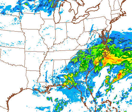 I still wouldn’t be surprised to see some of this try to sneak into eastern Ky.
Temps behind this will bounce back some with readings in the 50s for highs on Saturday. A cold front will work in behind this on Sunday and deliver a quick shot of cooler air. The models disagree on what happens after this with some trying to really warm us up for a few days. The European Ensembles have a spring tease showing up into early next week…
 The European Model also has this milder look and takes us well into the 60s by the middle of next week…
i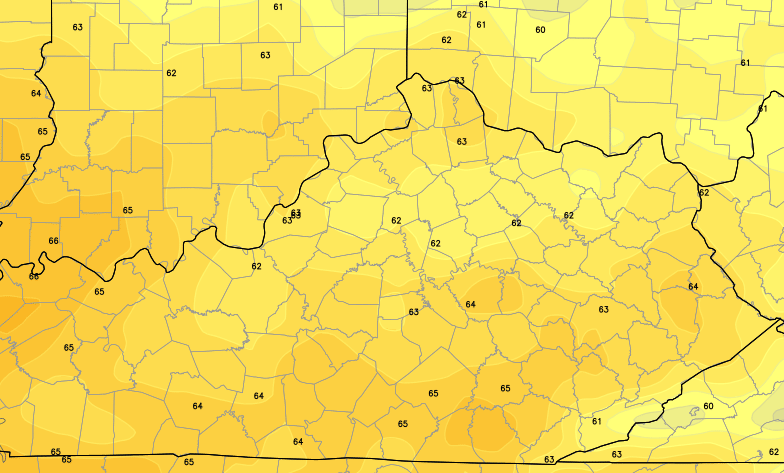
That would be awesome and I am cheering the Euro on. I even have my weatherdude pom poms out for it. 😉
Unfortunately, all of the signals are for a much colder period returning shortly thereafter…

Seems like we’ve had a brief mild up before every significant push of wintry weather since back in November. Is mother nature about to repeat herself? I think that’s a strong possibility.
Enjoy the day and take care.

All I know is that winter does not have much time left. Case closed.
I sure hope winter decides to look at the calender and move on.So far it pretty much walked all over Fall for the most part.Even some cold days in late October and never seemed to totally go away.Hope winter isn’t planning to snuff out Spring too.It will take at least two warm days to melt the ice on my drive and roadway.
Any predictions on a sunrise happening this morning?
I usually sleep through it. 🙂
Temp held steady at 30 here in knott county all night, was surprised to find no ice on my truck was figuring on a re freeze
The NAM throws quite a bit of moisture on EKY with this system on Friday but the GFS says it’s a complete no show – go figure!
I’m rooting for warm temperatures also. I’m tired of the cold and snow for once.
exactly what we need more cold rain just like the last system
As hard as it is to believe the entire Month of March 1960 averaged the same temp (around 29 degrees) we have had for the first four days of March in Lexington–moral–it could be worse.
Looks like the warm ups keep coming with major cool downs behind them. This has been the pattern since early summer 2013. Winter is not over neither is our snow chances. I feel a couple more ankle biters on the way befor old man winter calls it quits. Quite frankly he may just rear his head all spring and summer long. Sending cold shots south deep into summer.
Thanks for the update CB.
Shew —tell mother nature enough already! !! So ready for some warm weather. 🙂
Thanks Chris. Glad to see that we are getting a little sunshine today. Thought we would see some yesterday, but it was only out for 5 minutes or so. Hope today is better in that regard.
Don’t forget that today is statewide tornado drill to check out systems and such. I will take a few calm days for now. Hopefully the next upcoming winter stuff will be the last of it. Everybody have a great Wednesday! Thanks again Chris for all you do.
Hey CB, thanks for the heads up on all of the ice fog this morning!
Sarcastic much?
Your one stop shop for all things related to Kentucky weather.
supposed to be sunny and hit 50 today for London …. Knoxville met has us sunny and 62 on Friday and partly sunny and 61 for Sat …. then boom – Monday sunny and 65. I am not seeing winter sticking around here — granted temps will be a little lower than average of 58 but i’ll take any day in the 50s
I’ll take temps 45 to 55 even
Still a beautiful snow covered morning in London BUT we are ready for SPRING!! No tease…the real thing!
2 weeks until official spring and we still have a few cold shots ahead of us sounds like, will we get snow in April at this point is what I’m wondering?
I think we will get one more heavy snow in March–the pattern seems to support it. I remember March of 1996–we had a 6-12 inch snowfall across Western and Central Kentucky on the first official day of Spring. The 1995-1996 winter pattern has been much like this winter pattern. We also had snow in April of 1996.
Unexpectedly beautiful scene outside here in Lexington! Freezing fog, light snow, partly sunny, and thick frost on all of the trees (I believe it’s called hoarfrost.) All this creates the most precious scene I have seen all winter long. I have never seen this hoarfrost before thickly coating all the trees. Anyone else is seeing what I’m seeing?
No as we didn’t have clear skies we had some fog but that is about it.
Now its snowing moderately. Did met see this fog or snow coming?
Fog yes snow i dunno i have seen roads covered by snow but it was from the freezing fog in between barbourville and pineville i think it was last yr or the yr before
I had just a thin layer of ice on my back windshield which was nice compared to the inch to inch and half Monday morning. I am ready for spring. Hurry up and get here!
Very thick fog here in Nashville. As has been mentioned, freezing fog advisories are/have been out for much of KY and central/western TN.
Nashville hit 38 yesterday; while below predictions (perhaps due to periods of overcast), did finish off much of the rest of the ice/sleet. But unfortunately, the damage had been done. Lots of tree damage. There were still some isolated areas without power, especially to the west and northwest of town.
Nashville was virtually shut down early Monday with all the ice, jackknifed trucks and such. But for all the winter Nashville had on Monday, Nashville is still only up to 1.5 inches snow since autumn!
That was kind of surreal–the tornado sirens going off (for the statewide drill) along with piles of snow on the ground–and trees covered in ice from the freezing fog.
If you would’ve looked very closely, it was more like hoarfrost than ice. Look up pics of hoarfrost, they stick out like plates or needles.
I have no idea what “hoarfrost” is. I’ve been following weather for 30 years or so and that is a new one on me! 🙂
Clear blue skies in knott county temps feel like they are really taking off
Bring on Spring 🙂
I’m with ya now Barb, I won’t wish anymore snow on you 😉
unfortunately, which is usually the case in Kentucky, we won’t see much real “spring”. It will go from cold to oppressive in a matter of just a few weeks, once the “blowtorch” finally arrives. ugh…
Considering the ongoing tornado drills, NWS Jackson (KY) has a link about tornadoes in east KY (click here):
As CB has touched on before, many early tornadoes in east KY could have been missed considering the topography blocking vision, the isolation, and that east KY had relatively poor coverage by weather services until the last few decades.
A few years ago, I chatted with a NWS Jackson (KY) met and he mentioned a 1995 long track F2 tornado from near Hazard (narrrowly missing the airport) to near Hindman was somehow not included on official reports; the map seems to indicate this.
Of course the 2012 tornadoes really stick out on the map.
The map also shows some 1933 twisters. Including an F4 just barely south of Jellico TN that then wiped out Pruden TN neary the KY line. This tornado was headed for Middlesboro KY, but lifted before reaching Middlesboro. Another 1933 long track F4 twister (likely from the same cell as the Pruden storm) then hit Kingport TN.
Dont look now, but the Euro model bringing another snowstorm a week from today. As Chris Mercer said, this pattern is ripe for another snow event or two to unfold. Maybe heavy? Who knows.
*week from tomorrow
We were at 50 or above 8 out of 28 days in February. That’s not bad for February, considering all the cold we have had.
50s look like a possibility in each of the next 7 days and CB is saying 60s after that. I’d say we were looking at brief cold shots but an overall spring pattern. It’s all in how you look at it. Or how you word it as the case may be.
Topped out at 49 today, heard some frogs hollering out, spring ain’t far away
Wow–eeked 40 in Lawrenceburg–still lots of snow left. I don’t think winter is done yet.
I earlier today noted the webcams CB has on his threads, and they showed a reversal of what has been the norm this winter (and what is the norm anyway). Bowling Green has had relatively little snow this season until Sunday.
So this time, places like Louisville, Lexington and northern KY had vanishing snow cover but Bowling Green was still very white. NWS Louisville records show the stubborn overcast in Bwg not breaking up until later while other areas already had sunshine.
Even right now, Bwg is still a few degrees cooler than other KY cities; you don’t see that too often.
I am not a trained met..just a weather enthusiast…but my take is the pattern is very interesting in the next 7-14 days..do not be surprised to see a major winter storm develop in the gulf and deliver a monster storm somewhere in the east…all I am saying is the pattern coming up matches well with patterns in the past that have produced major storms in March
I agree with you–the pattern is similar to March of 1996 (a storm hammered the Western 2/3 of Kentucky) and March of 1993 (a storm that hammered the Eastern 1/3 of Kentucky). Where the storm takes place is the key. Winter is not over for the Eastern U.S.
I loved seeing the sun today.Chris would like to hear your thoughts on the storm late next week? I heard your ole buddy Tony C mention this evening on wsaz thoughts? Hope everyone has a great evening.
A couple of SkyWarn courses are coming up by NWS Jackson KY, including in Inez, Owingsville and Pikeville.
http://www.crh.noaa.gov/jkl/?n=spotter