Good Friday, everyone. We have a pretty good start to the weekend taking shape across Kentucky. This will be our first weekend without in snowing since early January. Yes, you heard that correctly. That’s one reason your friendly weatherdude has been dragging backside of late. 🙂
While the focus is on the milder air… winter isn’t going to go away. Spring is just teasing us over the next several days and we could be seeing snow before next week is over.
Highs today will hit the 50-55 degree range for many with a mix of sun and clouds. A few showers will be possible across far southeastern parts of the state. Here’s regional radar…

Saturday will be breezy and rather mild with mid and upper 50s. Clouds will increase ahead of a cold front that arrives Saturday night and early Sunday. This may produce a shower or two. Temps will come down behind this front, but it doesn’t look very cold. Sunny skies return before Sunday is through.
Thermometers early next week will mild up into the 60s for many. That looks to come crashing down with a storm system rolling across the region on Wednesday. The European Model has been all over this for a while. Take a look…
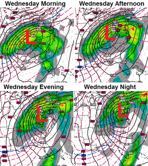
That would be a rain to snow solution and we need to keep a close eye on that setup. It COULD lead to accumulating snow setting up around here or very close to us.
Check out what that storm does to our high temps on the same model run…
Some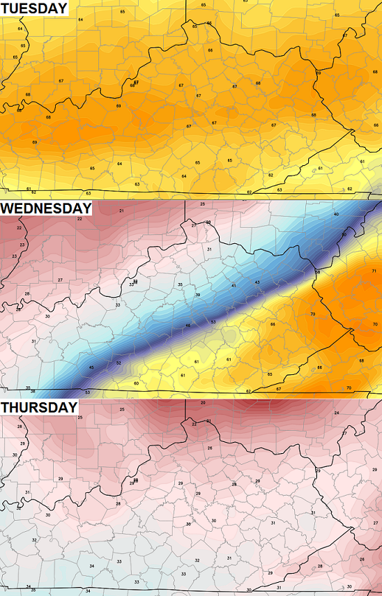
Some of the other models aren’t as wintry looking as the European and I think most of us would hope they turn out to be correct. Enjoy your day and take care.

YES……
I have had ENOUGH snow and cold for what seems like a Y E A R of winter…..
Could care less if we had anymore…..Even still, it’s the weather and it is interesting to see what will happen.
Best time of the year other than Kentucky Derby. Go Cards!
With such big changes in temps are we looking at possible storms, too?
Looking forward to Tuesday’s high temps!
I’m really disliking the Euro. 33 degrees in Louisville and 70 degrees in eastern ky by Wednesday.
Thats how we roll
Pfffffft goes this blog. 🙁
Come on Chris let winter be winter. We just have under two weeks left. If snow is in the forecast so be it. Still would rather have snow than cold rain.
THiNK RAIN #teamrain
Meteorological winter is over now. Temps are supposed to be mid 50s. Would much rather have temps to enjoy the outdoors instead of going twenty degrees below. I would be happy with average right now. Winter is over. Does anyone really consider mid-June to still be spring?
amen …. London is starting to be above the normal …. we’ll hit 60s tomorrow and should see 70 by Tues. the crashing down will last one day (thurs) and then start easing back to normal or even above. btw, what happened to forecast of winter lasting all month of march and all the way to april 9th … ? funny, not mentioned any more and funny how everybody gets hyped over snow and ice storms but say nothing about warmer temps!
Kyweathercenter is interesting regardless of the season. For those of us who love all things weather, this site is of value every day of the year. Thank you, Chris Bailey for all the information you bring to this site, and for the humor, too. We truly appreciate your dedication. Looking forward to what spring may bring! Tell us more!
It seems like everyone thinks its supposed to be in the 30s and 40s all winter and once it’s spring, (or almost) and everyone thinks the temps should jump to the 60s and 70s. This time of year, it’s is more normal than not to have 70s one day and 30s the next. Happens many times every spring and fall and people tell the weather to make up its mind as if this isn’t normal. Thats what makes March normal. With average highs in the 50s, 20° above average is 70s and 20° below average is 30s. Personally, I’m completely fine with more snow and would like more. But even if not, I’m ok also.
Yeah be warm a few days cold a few days it’s typical march weather. I figure we get another toe biter sooner or later
For someone who sometimes slyly criticizes CB for being sensational and irresponsible in how he relates to the public, he certainly can put out some gems of his own from time to time.
http://twitter.com/WXinKY/statuses/441599097393270784
Who are you referring to–Shawn or MJ. I’ve always found MJ to be very reasonable and professional. Shawn can be quite abrasive.
Chris not a sensationalist nor rude to the public.
Right at 50 here at 10am gonna be a great day
I find it interesting that people were screaming “where is winter” in November and they want it to be over in Early March. March is actually a colder and snowier month (on average) than November.
Chris we just had our first real taste of winter here in southern KY. I can remember when we got big snowstorms in March. But that is like today, with everything else…everyone is in a hurry to get something, weather included. We want snow when we want it and spring when we want it I have been trying to slow down and just enjoy each day as it comes. I am a lot less stressed that way, and find myself enjoying something about each day, no matter what the weather.
I had my taste a few week ago this past weekend all i got was a coating. But i’m glad you got yours 🙂
Thanks, Chris. Going to get out and enjoy this beautiful weather while we have it! Maybe the cold shot next week will be winter’s last hurrah. (Well, I am always the optimist. 😉 ) At any rate, we wioll enjoy each day and take them as they come. Everyone have a GREAT Friday, and enjoy this beautiful weather! Thanks again Chris for all you do.
Looking forward to storm season now!
While I enjoy watching the genesis of winter snow storms(even though I’m more of a warm wx fan), I find the spring severe wx season to have the most interesting wx dynamics.
This of course does not mean anyone wants tornadoes to threaten lives and property. But spring makes summer and early fall seem dull dynamicswise, except for hurricane season and perhaps the occasional derecho. As nice as September is weatherwise, the dynamics are not all that interesting.
Indeed, the tornado threat made me become a SkyWarn spotter for the NWS.
Back in 1998 when I was a rambunctious teen near Cleveland TN, a tornado touched down only a short distance from me and resulted in a fatality (same day as the infamous downtown Nashville twister and of the so-called “Forgotten F5” in south-central TN). Didn’t even know about the twister near me until later, which kind of shocked me a bit out of my teen funk and into the reality that wx is both beautiful and stark.
52 degrees in Louisville feels like 80 to me lol
bright sunshine and 61 in London; was supposed to be a high of 57 today …… feels awesome. went down this morning to laurel lake and caught 10 largemouth, 2 pretty good size – fish everywhere on top of water, evidently they are liking this sun too.
Louisville sitting at 60 degrees which is 3 degrees warmer than Orlando Florida at 57 degrees. San Diego is at 63 degrees goes to show what a southerly wind and a higher sun angle can do in the month of March. 🙂
Temps over achieveing today in frankfort, lovin ever minute of it, near 60 but feels like 70s 🙂
63° here in Bardstown atm…5:33pm…
I can’t believe I’m saying this…..dare I??…….but the bare ground looks so good with the white going away