Good Saturday afternoon, folks. Our weekend is off and running on a sensational weather note today with thermometers heading toward 60 or a little bit better. This is part of a nice little period of spring that carries us into early next week. The later part of the week… not so much.
Highs today may hit 60-65 degrees for many areas as winds pick up and clouds increase. Those clouds are ahead of a cold front that swings in tonight with a shower or two. Sunday will find the sun taking over as the day wears on with highs in the upper 40s to low 50s. This qualifies as a wonderful weekend in my book!
Temps will soar early next week…
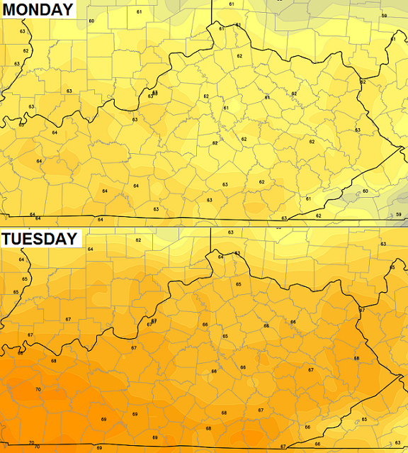
We might be able to squeeze a 70 degree day out of this. Just when you think we’re over the hump and heading into spring, this comes our way for Wednesday and Thursday…
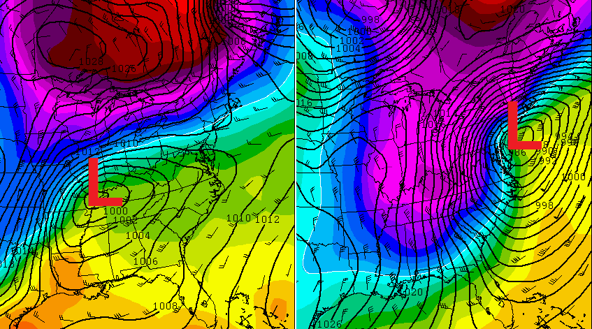
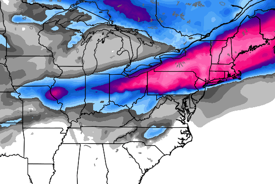
That should be a rain to snow maker for much of the region. Here’s where the European Model thinks the winter weather will be during this time…
 Here’s hoping this thing totally disappears in the coming days. I’m not going to start the #teamrain thing again… that didn’t work out too well with the last storm. 😉
Friendly reminder: Set your clocks up one hour before going to bed tonight. Daylight Saving Time returns at 2am Sunday.
Enjoy the day and take care.

Saturday afternoon?
I thought I overslept! lol
Maybe he was counting on. People sleeping in today lol
Beth if a minor anachronism is all you care about then it’s going to be a good day.
Honestly think that this upcoming storm will be the last chance for a significant winter storm in the area.
In the land of the forgotten wehad mid 60s yesterday so maybe 70 today? Also in the land of the forgotten the rain train worked perfectly just like it has all winter keep the faith Mr. Bailey
So much for 50s at 12:30 we are already at 64
Topped out at 68 today
Spring can’t be too far away. The peepers were out last night. First time I’ve heard them this year.
thanks Chris. our family and friends appreciate all the work you do.
gonna enjoy these warm temps and hey if we get another snow or two that would be cool!
Typical March weather never know what you
Your going to get.
I hope its a HUGE snow storm for our last Hoorah for Winter. I am looking so forward to Spring even though I am a snow lover as well. We have had our fair share and then some this Winter Season. Thanks Chris for all you do!!! I don’t know any other meteorologist that goes above and beyond the duty to keep us informed so we can prepare. Will be watching closely for this next storm. Have a Blessid day!!! Stay safe everyone and enjoy today!!!
I should proofread!!! What I meant to say is I don’t know of another meteorologist that goes above and beyond the call of duty to keep us informed so we can prepare!!!
Wanna see who had some of the best winter forecasts or worst? Take a look… http://www.wlky.com/weather/grading-the-winter-forecasts/24827078
The 3 largest snows of the past six years in Lawrenceburg have all been in March. (March 3, 2014; March 5, 2012 and March 8, 2008). Six years ago today was the largest of the bunch–about 9 inches at my house.
Anyone else remember this storm?
http://www.crh.noaa.gov/images/lmk/mar_08_snow.PNG
I remember 2008 anyway, as that was my senior year at WKU. IIRC, we had around six inches. A lot of 21 year old students were suddenly transformed into 10 year olds, and I was one of them 😉 . One of the few bigger snows we ever got while I was in Bowling Green.
Those were the days…… 🙂 .
– – – – – – – –
This was on the heels of the infamous Feb 5 2008 tornado outbreak:
http://en.wikipedia.org/wiki/2008_Super_Tuesday_tornado_outbreak
Didn’t it also come in on a Fri. night/Saturday??! I remember we’d just gotten our new Keeshond puppy a few days prior and taking her out in it for pix , and all you could see was a little curly “piggy-tail” sticking up! We had about a foot here in Bardstown.
Yes, it was a Friday/Sat event. WKU was just starting its spring break, but the snow delayed at least somewhat the departure of me and other students from Bowling Green.
How many 8″+ snows have happened before? Are we due for another one?
(For Lexington)
Good question……Not sure about prior to the 90s. I’m sure the 80s and 70s had some…
For sure I know:
Feb 1998 – 20 inches
Jan 1994 – 12 inches ( I think)
Jan 1996 – 11 inches ( I think )
So we’re probably due for another one?
13 on a single calendar day. Not sure about storm totals. Last one was February 4, 1998.
If I was living here at that time, that’d be my best birthday present ever.
Beautiful day today.
Think I need to grill out this weekend. Can’t wait to taste burgers from the grill!
Interestingly, the GFS is less bullish on the snow. For those that are a bit tired of the wintry wx, let’s hope the GFS is right 😉 although the Euro tends to get a somewhat better picture this far out. This said, all the models will of course be adjusting over the next few days.
Some good news is for now anyway, indications are that severe t-storms may be rather marginal and to the south.
I wonder if we will have a strong spring storm season or a fizzle due to the less warm air?
Speaking of fizzle, Cats appear imploding for a second straight season. No excuses since 100% his own players now. The one thing you can say about Tub teams is at least they were competitive and he won a championship with some legacy players too.
Instead of physically whipped like Billy teams, this one seems mentally whipped and over the season and at least two of them are thinking NBA rather than CATS.
Somebody made a seemingly good point. The reason the last two teams actually started playing worse than better is when key players start realizing they are not one and done, so start a self pity party that drags the team down with it. Makes sense as to why the last two teams have not gotten better through the season and the other direction instead.
Hold the phone, folks, the Kentucky men have cut the Florida lead to six!
And the Kentucky women (who defeated Florida yesterday) are currently leading #5 South Carolina in the SEC womens tournament.
And this is from a dude that grew up a Tennessee fan (and TN fans have had our share of sports suffering the last few years).
When was the last time KY got swept by two teams in the same season?
Also, has KY ever lost to a same team three times in a season? That is very possible if KY plays Arkansas or Florida in the SEC tournament.
A few national sources I’ve checked out seem to be generally hinting at a normal to somewhat below normal severe wx season for the nation.
Needless to say, even a below normal spring can have a brief period of unleashed fury; last year was a quiet spring in the USA with the big exception of about a week or so in Oklahoma.
CB has mentioned he will soon give his thoughts on severe wx for our area for spring 2014.