Good Monday, everyone. We have a nice little shot of winter air moving into the bluegrass state over the next few days. This will even bring a little bit of the white stuff to the bluegrass state. Will this be the last round from winter before we can turn the page toward spring? Hmmm
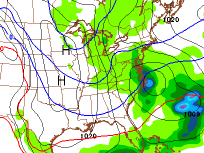
Highs today will run in the 40s with a mix of sun and clouds. The clouds will thicken up later today into tonight as a system zips in from the northwest. That will bring a period of light snow and snow showers our way into Tuesday and Tuesday evening…
 That may have enough juice for a grassy coating with a little more possible in the mountains of eastern Kentucky. Gusty winds will make those 30s feel even colder. Speaking of colder… check out the lows by Wednesday morning…
 After another day in the 30s, temps will quickly rebound toward 60 by Thursday. That’s when moisture returns from the southwest ahead of a cold front. Showers and thunderstorms will increase into Friday and the start of the weekend.
The overall pattern looks to trend warmer as we head into the end of March into early April…
t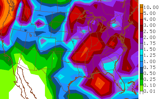
That pattern would be skewed warmer than normal and may also turn rather stormy. Check out the amount of rain the GFS is spitting out over the next few weeks…

Have a great Monday and take care.

Its going to turn out to be a very good March in the southern part of the state. Looks like we will end up with 20 plus days of highs greater than 50 degrees. Pretty typical March weather. Mostly warmer days with a cold day or two every week or so. Not bad. Go CATS!!!
It has definitely been a MUCH nicer March for us than last year in the southern counties. Here’s to hoping that continues with a nicer, dryer summer as well.
April might be our March this year, as far as significant storms.
That is my concern also.I am not looking forward to tornado time whenever that may be.I have been feeling that maybe since March has been nice and mild we may get whammed during April.I sure hope not.
19 here in Lawrenceburg this morning. Hope this is the last morning I see in the teens until next November or December.
GFS has us all in the low to mid 70s by next monday.
This March is on pace to have the lowest tornado count on record. If we don’t get any tornadoes by the end of March, the record lowest tornado count of 6 may be broken. So far, only 4 has been recorded this month. The 6 tornado count was recorded in 1951, only a year AFTER tornado record data began. Keep in mind that there weren’t many people back then to report tornadoes than there are now. That’s why the # of tornadoes is increasing due to better coverage that there wasn’t in the 1950s, which makes this much more significant of a record if it were to be broken. More info here: http://www.weather.com/news/tornado-central/march-tornadoes-may-set-record-low-20140321
http://www.wlky.com/weather/an-amazing-low-tornado-total-for-march/25097964
Up until about the 1950s, it was actually forbidden to broadcast any warnings about tornadoes. No joke. Seems the feeling was that this would cause the public to panic.
For fun, here (click link) is a 1950s tornado prepareness film that signaled the trend towards better tornado preparedness, even if the film is a bit corny in ways and has some obsolete safety advice.
I had 20 in Carrie this morning, glad I kept the long johns out for a few more days
It was showing 20 on the thermometer on my back porch this morning too.Has warmed up quickly though.Around 45 now and it a beautiful sunny day.Trees and bushes are budding out and a few flowers are starting to bloom.Thankful for this day.