Good Thursday, everyone. Temps are taking off across the bluegrass state as milder air blows in. This milder pattern looks to take control for the next week or so. The question on everyone’s mind is… does this mean winter is over? I’m still trying to figure that one out.
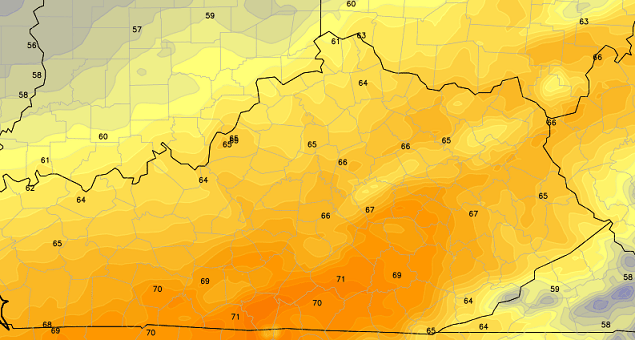
Let’s talk about the good and that’s the nice temps moving in today. Readings will head toward the upper 50s and low 60s on a gusty southwesterly wind. Gusts of 35mph will be possible at times. Clouds will increase and this will lead to a shower threat in the west and north before the day is through.

Showers and thunderstorms will really increase tonight into early Friday. That’s when a weak system crosses the state. This thing zips through here and leaves us with some afternoon sunshine . Temps may soar through the 60s…
Another system brings showers our way Friday night into Saturday. This will be a much colder rain as thermometers drop throughout the day. There is an outside shot of a snowflake showing up somewhere across the state late in the day.
This chill doesn’t last as temps head toward 60 by Sunday under a mostly sunny sky. Temps early next week will make a run at 70 degrees with gusty southwesterly winds blowing. There is a chance for a shower or thunderstorm on Tuesday.
A much bigger system tries to work our way by the end of next week…
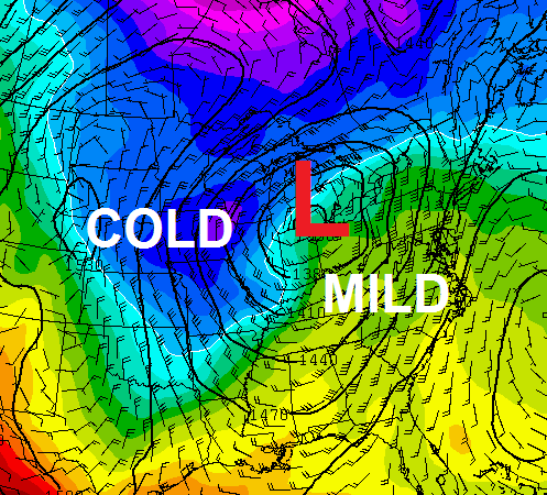
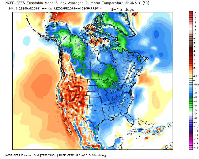
That could bring the threat for some strong thunderstorms our way as the storm rolls into the Great Lakes. MUCH colder air should filter in behind this and that may usher in another colder than normal pattern. The GFS Ensembles are seeing this…
 Have a wonderful day and take care.

I can deal with slightly below average temps all summer.
With that being said, spring weather lovers are patiently awaiting the start to the very active part of severe wx season but it doesn’t look to be happening very soon without a huge warm up.
I’ll happily avoid power losses, stress on the animals, and property destruction. For those who’ll be complaining about the lack of severe wx, may you find a microburst and lightning strikes localized to your own homes. Make sure to post the pics for us to view. Everyone wins!
I’ll happily avoid those things too, LD. But severe weather is something that happens whether we like it or not so we might as well take the opportunity to be fascinated by it and learn from it.
One can also be prepared for severe wx before it happens.
On this note, CB will be happy to learn that Morehead State University (where Chris earned his broadcasting degree, he also received his meteorology training from Mississippi State) is now considered to be “Storm Ready” (click link here) by the NWS.
This is a good thing. I’ll take a cool spring (say, like 1997) if it means severe weather is almost non-existent!
I’d rather it be warm myself.
Jeff–I don’t mind warm weather-60-80 degrees and sunny feels pretty good. We’ve had very few of those days–maybe we can have some more going into April and May.
At this time, the SPC has a “Slight Risk” of severe wx today and tomorrow for parts of Missouri and for western Tennessee respectively. Time may tell if Kentucky will later be included or not in this risk area.
At any rate, strong damaging winds and large hail will likely be the threats with the highest chances today and tomorrow; a relatively low risk for a twister or two.
Severe threat is non existent for KY and to be quite honest it was never there.
Well, no real severe threat for early Thursday.
But SPC’s mid-afternoon update pushes the Slight Risk area in Missouri even closer to Kentucky for this evening, virtually to far western KY’s doorstep. Hopefully this trend won’t continue, but something to watch. SPC expects the Missouri storms (currently a Tornado Watch there) to weaken somewhat through the night.
SPC’s next update for Friday won’t be until early morning, but it will be interesting to see if the Slight Risk threat in western TN is expanded (or not) to include parts of western KY close to the TN line.
Granted, hardly much severe chances for northern KY, even if there still could be an occasional rumble of thunder.
This March is going to wind up almost as cold as last March. Even South Central Kentucky has been in on the fun–Bowling Green is a 5.5 degrees below normal for the month through yesterday. My yard is actually still frozen right now. April 10 is the latest I’ve ever gone without having to mow–this year is going to push that.
Cool springs like this keep the trees from coming out too early, as they did in March 2007. That year March was way too warm, and the trees were completely covered in leaves by this date. Then we had a freeze in early April that killed all the new vegetation–turning everything black, and making for a very ugly spring. I’ll take a cool March over a warm one anyday.
I remember that in 2007. We had a very warm stretch of days from about March 25-April 3. Then the bottom fell out. It was Early May before the vegetation really recovered.
This will be good for the fruit trees this year, might be a bumper crop for cherries, apples, pears!
Yes, Chris, the trees had to put out a whole new crop of vegetation that year. But two hickory trees on my street never did recover. They gradually declined over the next few years, and one died. The other one is still sickly looking. The water (sap) in trees can freeze when temps fall below 25, and if that happens, it kills the very thin layer of tissue that transports food to the tree from the roots. Usually the tree eventually dies.
So, I would prefer a cool March over that happening again.
Temp has really surged here in Lawrenceburg. It was 27 sometime since midnight (33 when I got up, so the low happened sometime between midnight and 6:00) now it is 57. A 30 degree swing in 12 hours–impressive!
High temps for March 2014 going to end up four or five degrees higher for CKY and probably seven or eight higher for SKY than what it was in March 2013. Average temps may end up only a degree or two different, but all that matters to me this time of year is how warm it gets during the day. Could care less what it drops to overnight as long as it gets back warm the next day. Should end up with seven or eight days more of 50 plus temps than what we got last year in March. I will take it. A lot closer to a normal March than what we experienced last year.
Will still end up a couple of degrees short of average highs on the month, but much better compared to the 10 degrees that we were off last year.
Hold on to your hats 😉 ! A 40 mph gust recorded via KY Mesonet in Union County along the Ohio River.
Also a 37 mph gust earlier today in Clarksville TN.
Completely calm here in east TN. Not even a hint of a breeze in the foothills of the Smokies. The higher elevations may be a different story.
The Mountains and Winds:
ODD – I remember growing up in western NC…Brevard to be exact, just south of Asheville by maybe 25 miles or so..It could be a raging wind storm in Asheville and in Brevard it would be so calm with no winds at all. This was especially noticeable at night……It always seemed so calm and night but daytime could be windy. I think the certain areas within the mountains are less prone to wind……I know after having lived in NC, then Knoxville, and now Lexington, central KY is by far the windiest of the places I’ve lived.
Can’t believe how HARD these winds are here in Bardstown??! They just started gusting, sounds like the roof is about ready to blow??!