Happy Friday, folks. We are rolling our way into the weekend on a windy and sometimes wet note. Temps will be all over the place, but the overall theme is for much warmer air to surge in as we head into next week. It’s time to get your spring on! 🙂
Scattered showers and thunderstorms are out there early today, but that action moves to our east by this afternoon. Winds will continue to be gusty with some sunshine likely before the day is finished. Make regional radar your BFF for the day…

High temps this afternoon will surge well into the 60s for the entire state.
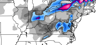
Another round of rain swings in tonight throug Saturday. Temps will drop during the day and it may get cold enough for a period of light snow. Yes, I said light snow. The GFS even shows this…
 At some point you just have to laugh. If not, you may go crazy.
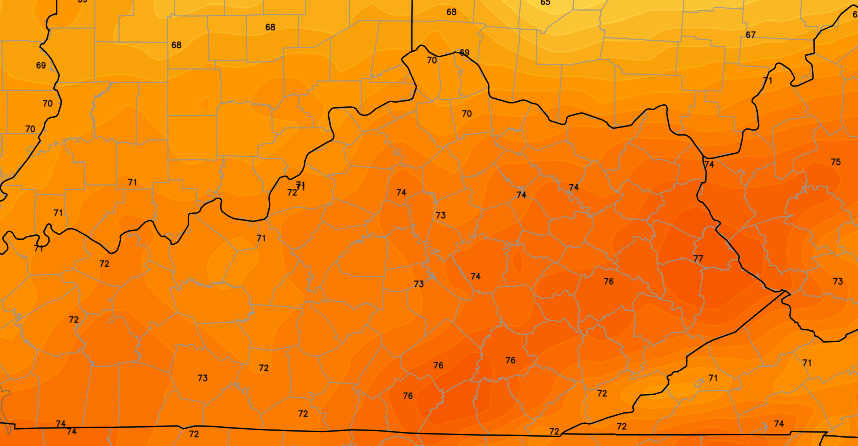
Windy and mild weather shoots in here on Sunday and takes us into early next week. 70 or better is possible from Monday through Wednesday. Look at the numbers from the European Model for next Wednesday…
That may come with a booming price. I’m starting to zone in on the potential for strong or severe thunderstorms from late Wednesday through Thursday.
Check out the setup from the European Model…
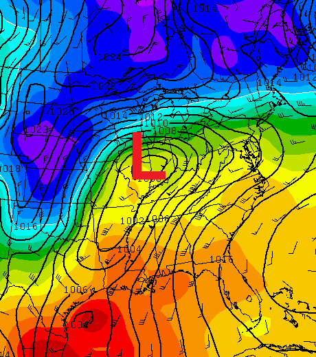
We will have to see how that works out, but the signal is there from this far out.
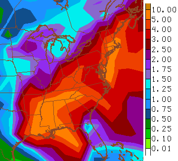
This is a busy pattern taking shape through the first half of April. Rounds of showers and thunderstorms may become common during this time as spring tries to finally trump Old Man Winter. The GFS is showing a lot of rain over the next few weeks…
 Make it a great Friday and take care.

The name says it all.
I am completely in favor of the cards going. I have a few suggestions as to where they could go, if you are interested! lol
Wednesday and Thursday seem interesting as far as storms go. The temps, however, are something to look forward to. Anyways go Cats! #BBN
Very much looking forward to the continued warm temps, despite the short cold snap for this weekend.
The Storm Prediction Center is indeed already picking up on possible elevated chances of severe weather the middle of next week. It would be ironic if we had severe wx next Thursday, as that will be the 40th anniversary of the “Super Outbreak” of April 3 1974.
http://www.crh.noaa.gov/lmk/?n=april31974
Interesting day yesterday–the high was at about 10:00 P.M. Crazy wind last night as well.
Until today only Monday was looking nice but now seems like folks are finally locking in on a relatively warmer pattern next week. Mid to upper 60’s are being called for in Northern KY as of now. I’ll take whatever we can get at this point, even if there is a price to pay at the end with storms.
There has only been one 70 degree day so far in Lexington this year. If we don’t see another one by the end of the month that will tie the record for the fewest 70 degree days to start the year. The record at the end of April is 9. Hopefully we can squeeze out more than 9 70 degree days in April and not tie this record as well.
Thanks Chris. I am liking that the warmer temps are coming. I hope we can get a little bit of sunshine to go with them. Except for the wind, yesterday was a fairly nice day around these parts. We did have mostly cloudy skies, but it stayed dry, and temps were in the lower 60s by afternoon. Here’s hoping that we don’t get a soggy springtime and then go straight to summer. A few days of 70-75 and sunshine with light breezes would be just what the doctor ordered. 😉
Thanks for all you do Chris. Everyone have a safe and happy Friday! and GO CATS!!!
Still waiting on spring in frankfort, sounds like ugly weather Saturday, then a nice weather spell lets hope!
GO BIG BLUE!
Wow, should I actually say this? It a actually feels a little humid outside. Not much, but still noticeable.