Good Sunday, folks. We are ready to light a little fire under your thermometer in the coming days. A prolonged stretch of summer air is on the way for the first full week of May. This can only mean one thing… the complaint department will be filled with people complaining about it being too hot. 🙂
Today will feature temps taking off into the middle and upper 70s. Some low 80s will be possible in the west and far south. We do have a weak front approaching from the northwest, but this will never make it through the state. It will close enough to fire up a few showers and thunderstorms later Sunday… especially in the north.
Follow the temps and any storm that goes up…
Current temperatures


The pattern early in the week finds summer in the plains states and expanding into our region. That settles in by the middle of the week…
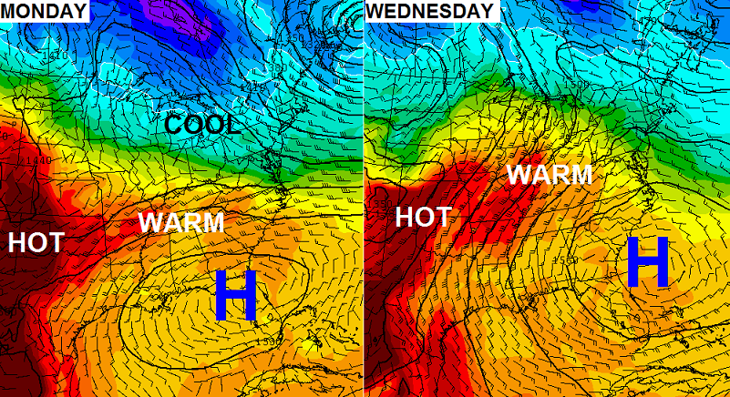
Highs in the 80s will be common for the upcoming week and I wouldn’t be surprised to see some mid to upper 80s on any one day.
A cold front will then work toward the area by Friday and bring showers and storms to the region…
The threat for thunderstorms looks to carry us through next weekend.
Have a stupendous Sunday and take care.

Stupendous…..LOL – what a word choice. For some reason that made me bust out laughing. Not sure why
It reminded me when I once heard someone say to someone else, “You’re horribly attractive”
Brace yourselves! The “if you don’t like X or Y weather then move to Z” posts are coming.
I won’t be complaining! everyone kept saying that is was COLD the last few days. not me, I kept saying, this is MUCH better than -14.
Thanks Chris. Looking forward to a nice week and since I have to work next weekend, it may as well rain. Have a wonderful Sunday, everyone.
I’ll be glad when winter gets here! Blinding blizzards and crushing ice storms! It’s to hot! Waaaaah! 😉
I saw a friend of mine yesterday and I think he summed up my feelings when he said “the warmer it gets the better I feel”.
Migration this weekend. Little warblers all over the place. They move through just ahead of summer every year. Nice weekend weather. I would enjoy a few months of this type of sunny weather.
I think the warm weather makes people more happy and easy going.but…there’s a catch to that…get it too hot and mix humidity…and people get very angry and impatient easily..
True…m?
Love the nice weather…but once you get into mid 80’s…automatically too warm for me. Hopin’ we break out of this dull, boring pattern! Love me some storms in the springtime.