
Good Monday, everyone. The first full week of May is upon us, but it’s going to feel much more like late June as temps take off. It’s the inaugural “I Love The 80s” post and it’s usually one that brings a lot of smiles to the faces out there. I always aim to please!
Speaking of… I even have a look way, way, way down the road.
Let’s start with the short term. Highs today will hit the 70s in the north and northeast as we have a weak front in the area. That front may touch off a scattered shower or thunderstorm. Farther south and west… mid 80s are a good bet.
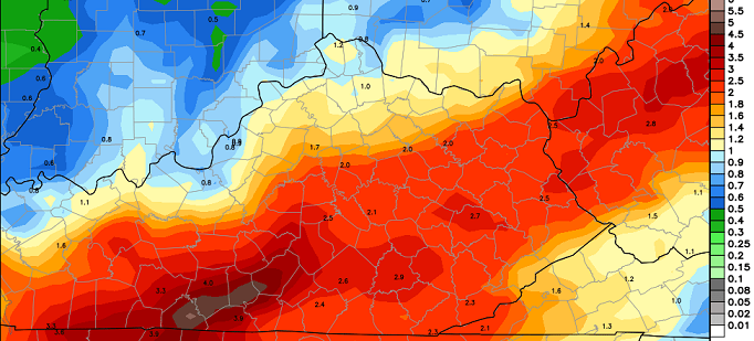
Current temperatures


Highs into Tuesday and Wednesday will really take off for the entire region. Low and middle 80s should be common and a few spots could sneak into the upper 80s. That should carry us into Thursday, too.
Friday will find a cold front creeping in from the west. That boundary looks to slow down as it moves in here and should hang around through the weekend. Rounds of showers and thunderstorms will become likely and we could be talking about strong or severe storms. Heavy rainfall will be possible and the European Model is cranking out some good totals…
We’ll have to keep a close eye on that setup as we get closer.
It’s always fun to take a look at the longer range forecast models to see what they are saying. The JAMSTEC Model has had a decent track record of late and it shows a familiar pattern as we roll through the next three seasons…
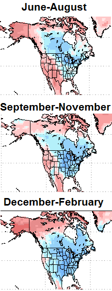 If you had to pin me down on a super duper long range forecast, it would look something similar to what you see above.
Have a great day and take care.

Hopefully that blue shading over us during June – August means this Summer will be cooler than usual.
*sigh*
I’m ready for October already.
I’m with you. Although October can hold off a bit. This week may change my mind on that opinion. If a cooler summer means what we had this weekend nobody can complain.
Complaining about the weather will not change anything. Accept it when it happens.
I don’t even want to see SEPTEMBER, OCTOBER, NOVEMBER,DECEMBER, JANUARY, FEBRUARY LOL
Lovin the 80’s
CB, I recognize the Rubik’s Cube in the graphic.
But what is that funny looking thing to the right with two eyes and a straight, white, Anthony Davis-like unibrow?? 😉
Ok, I’m not quite that young (just turned 30 not long ago). But I had to look at it a while. Guess I’m getting old!
– – – – –
Currently 83 in Nashville 🙂 .
Mid 80s are long gone 90 coming most likely before the end of the day for my area
88 degrees official temp at 3:30 in Louisville could the official reading at the airport eek out a 90 degree temp before 7pm???
Models with temps seem to not grasp the power of a sw flow. Once again the models were to cool for high temps 84 was the forcast high for Louisville not 88 with a strong possibility of cracking 90 before days end.
somebody said Saturday that the models were to warm for this week turns out they were actually correct as WKYT has highs of 79 for today
The calendar on here is wrong. It shows Monday as the first day of the week and Sunday as the last day of the week.