Good Tuesday, folks. The surge of summer we’ve talked about for more than a week has arrived in the bluegrass state. Temps are reaching late June readings with mid to upper 80s over the next couple of days. While the warmth is the star now… storms will crash the summer preview party by the weekend.
Today will see a pretty big temperature gradient setting up from north to south across the region. A warm front continues to hang out in the north and will keep temps in the 70s for this part of the state. Areas farther south and west will be well into the 80s.
It’s always fun to take a look at the longer range forecast models to see what they are saying. The JAMSTEC Model has had a decent track record of late and it shows a familiar pattern as we roll through the next three seasons…
Current temperatures

Mid to upper 80s will be common for Wednesday into Thursday. One or two of the typical hot spots may head toward 90 degrees.
The threat for storms will increase from west to east as we head into Friday as a cold front slowly moves our way…
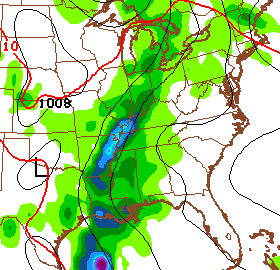
Some of those storms could be strong or severe and that begins a stormy weekend around here. Rounds of showers and storms look common through early next week. That’s when another system edges closer…
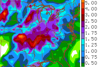
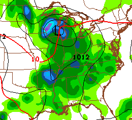 Very heavy rain is possible from Friday through Tuesday with 1″-3″ totals possible…
Have a great day and take care.

“We” again…
I’m fine with active weather like this. I’d rather see variations in weather from day to day than for it to be sunny and in the mid 70s the whole week, that gets kinda boring even though it’s nice weather.
“Boring”???? I’ll take a whole bunch of boring!
Yeah. I like the fluctuations. Sunny skies do get boring.
I’m wondering what the JAMSTEC model Chris posted yesterday concerning temps shows concerning precip through the rest of the year.
so more 90 degree days like yesterday i hope that doesn’t kill my new plants i just put out in the garden.
So I need to get the waders out after Friday, huh? 😉 I really hate that Saturday is going to be so soggy. It is my granddaughters 2nd birthday party. Oh well, I guess we will just have to party indoors. or in the garage. But I have to say I am liking the warmer air and temps.
Hope everyone has a wonderful Tuesday. Thanks Chris fo rall you do.
Yes, I’m hoping Saturday turns out to be better for Anna’s Birthday, too mom!
Mid 80s in frankfort yesterday just a little to warm for my taste, but not complaining after the winter we had, a few thunderstorms once a week would be great for the growing season, bring it on Chris!
It wasn’t a bad 90 yesterday on the SD with the wind and low humidity
These temps would feel much worse with higher humidity, I’m sure that is right around the corner!
Oh yeah i just hope the plants in the garden hurry up and take root so the heat isn’t so bad on them
I here ya, maybe the rain at the end of the week will cool us down for awhile so the gardens can get established!
Yesterday–pushed 90 with dewpoints in the 40’s, nice breeze, felt great.
Today–Mid 80’s, dewpoint nearing 60, little breeze, feels miserable.
The temp really doesn’t matter past 80. It is all about the dewpoint.
I asked a couple weeks back about the weather for my area on May 17th….I realize that it was a bit to far out to get a pretty good answer but since it’s just 11 days out I’d like to have any info. I’m having an outdoor party & would like to be prepared in case of rain. Thanks
Still a bit early yet. Maybe by Sunday or so CB can help.
Chris, you are by far the best meteorologist in these parts