Good Wednesday, friends and neighbors. Temps are heading toward the “hot” category over the next couple of days as July weather takes over. The hot weather will come crashing down as we head into the weekend as rounds of showers and storms come calling.
Highs today will hit the mid to upper 80s for much of the state and that will carry us into Thursday. Can one of the traditional toasty thermometers hit 90? Very possible.
A cold front will move closer to the region by Friday and this means showers and thunderstorms will be on the increase from west to east. Those storm chances will be with us into Saturday as the cold front slows down…
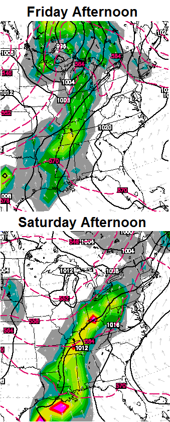
It won’t rain the whole weekend and I do expect some dry hours on Mother’s Day, but you may need a plan B to be safe. Additional showers and storms will be around into early next week and the rainfall could add up…

We will also need to watch for the potential for strong and severe thunderstorms during this time.
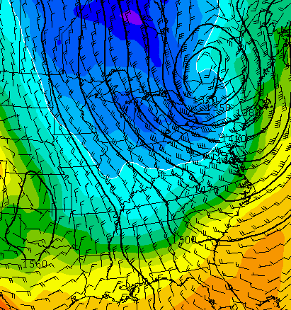
The models continue to hint at a decent shot of cool coming in behind all the storms by the middle of next week…
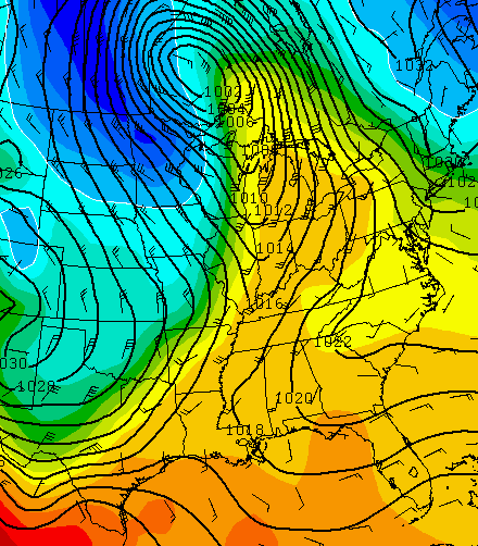 This pattern continues to be one that could deliver additional chilly shots over he next few weeks. The GFS is really hinting at this for next week…
Have a great day and take care.

Thanks Chris. When you say chilly, whT kind of chilly do you mean, highs in the 60s, or lower? Just asking. Have a great Wednwsday everyone!
Well, the GFS that Chris was looking at last night had highs in the 40s, but it now shows highs in the 50s and 60s. If this cold front does come by Tuesday highs will likely be alright but the nights could get pretty chilly into the 40s, can’t rule out 30s like it happened in mid May last year.
Just as I had said back in early March. Swim pools may not warm up to the swimming temps most people like this summer. Like 85 degrees and warmer. Lakes may stay cool as we’ll. get used to the cooler summers and harsher winters they are here to stay for a while.
Thanks CB for the update.
And you know this how?
There have been many people down here that have used their pools already.
You don’t live in Kentucky anymore remember?
Some friends have a solar cover for their pool. Perfect for sunny cool days. Indeed, if they neglect to take off the cover, the water will get too warm.
Bjenks:
http://www.wlwt.com/news/some-farmers-already-seeing-impacts-of-tristate-climate-change/25842244
Curious as to where you got your info that we are in store for cooler summers. According to the new report, the growing season will continue to be a couple weeks longer (since 1950) and the summer season warmer. Can you provide a link to your info? Thanks!
what has happened to the link to all the models……i have it book marked but it doesn’t work any more and when i go to this blog and click on the link it still will not come up……..any one out there with any answers.
No matter how cool it might get next week we are way above normal for now, wow, upper 80s to near 90 in spots the next few days!
I have had more 90 degree days this week than i want upside is it hasn’t been humid
Already 80 in frankfort, going to get toasty today!
While the Knox County Mesonet site hasn’t reported a temperature higher than 87 yet this week, every day since Sunday has been over 80 and today and tomorrow will make 5 days in a row at least.
Conversely, up here in Northern Kentucky they’ve been advertising only 2 days where we’ll see 80’s and it looks like they will be correct. We’ve been missing out on the heat.
how did you know i lived at the Mesonet site? 😉 The only day we haven’t hit 90 at my house is today so far and peak temp today was 87.4. Still yet 2 days this week is more 90s than i wanted or needed to have with the new plants just set out i suppose i should have planted last week.
I’ve been reading this blog since before Chris moved to Huntington.
Ok that answered my question 😉
I hope the gfs is correct next week.
That makes two of us.
Hold on to your hats! The KY Mesonet just recorded a peak gust of 31 mph in Trigg County.
A gust of 29 a while ago at SDF airport in Louisville. Also a 26 gust here in Nashville TN.