Good Thursday, folks. Our summer preview is about to turn into more of a typical spring pattern with scattered thunderstorms taking center stage. Those boomers will be around for the next several days and should be followed by a much cooler than normal pattern into mid May.
Highs today will be back into the mid and upper 80s on a gusty southwesterly wind. Those winds will blow additional clouds and moisture our way into Friday. That’s when a cold front slowly moves in from the west with showers and storms increasing. The NAM Simulated Radar shows a nice line of rain and storms by Friday afternoon…
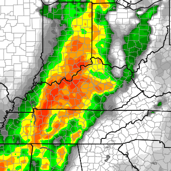
We will have to watch for a few strong storms to come from that line… especially across western Kentucky. Winds will be very gusty as the boomers roll through.
Scattered is the name of the game for the weekend. This doesn’t look like a washout and I do expect several dry hours for Saturday and Mother’s Day Sunday. Highs should be in the mid and upper 70s.
We will likely spike back into the low 80s for Monday and Tuesday as another cold front moves our way. This should bring a line of storms through the state late Tuesday and unleash much cooler air for the middle of the week…
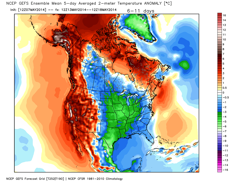
Highs may not get out of the low and mid 60s on Wednesday. A bigger shot of cool air is likely to drop in late next week into the following weekend. Check out the massive dip in the jet stream from the GFS Ensembles…

The end result looks to be temps well below normal for several days…
 Have a great day and take care.

Thanks Chris. although it has been warmer than normal for this time of year, I have enjoyed the beautiful weather and sunshine of the past few days. Got a lot done in the yard, and flower garden, but there is more to do.
Have a great Thursday everyone! Enjoy this weather!
Bring it on, I like cold/cool weather and almost never complain about it not even in the middle of winter. It’s better because the cool weather this time of year is just right to not use AC nor heater, saves some bucks. GFS has been on and off about a frost potential. EURO also has a slight frost potential also. Highly doubt it but we also doubted the extreme cold we had this past winter because it was too extreme of a scenario. Just sayin’.
Right there with you on wanting the cooler temps back.I can always add a few more clothes if its cold but can’t keep taking more off as it gets hotter.
I did really enjoy the days in the 60s and 70s.Worked in the yard and the garage,etc.Can’t stand the heat once it gets in the higher 80s.
Don’t really need any frost though.
I feel the same Israel
I saw similar maps of very cold air forecast days before derby weekend and that proved to be way over done as temps ended up in the 70s for derby weekend!
If we get cooler than 60s for highs it will shock me, the strong sun this time of year seems to warm the atmosphere faster than models can adjust to!
They weren’t overdone… recall the very cool days leading up to the Derby? Timing was the only difference.
I believe you, but some folks called for 50 degree weather just a few days before derby!
Turned out much warmer, cool sounds good after today’s heat 🙂
Do you have a timeline for the storms on Friday? I have a softball game in Richmond on Friday night.
Thanks! 🙂
Bjenks,
I replied to a post of yours yesterday (Wednesday) asking where you got your info on this summer being cooler. Can you give us a link? Thanks!
I rather enjoy warmer weather. I guess that makes me insane here.