Good afternoon, everyone. We continue to deal rain on the increase and this rain looks to become heavy at times through Friday. This comes as one low weakens over our region, allowing for another to develop to our east. That means some wraparound light snows wrapping in behind all this over the weekend.
The setup remains the same, but here’s a little breakdown:
- Rain continues to increase this afternoon and evening from the west and southwest.
- As the first low wraps up on top of us Friday, a corridor of heavy rain is likely to develop across areas of central and eastern Kentucky. A quick 1″-2″ of rain is likely with this.
- Wraparound light snows will be possible from late Friday night through Saturday morning.
- With temps around the freezing mark, whatever snow you get would be on the wet and slushy side. Some light accumulations will be possible for some.
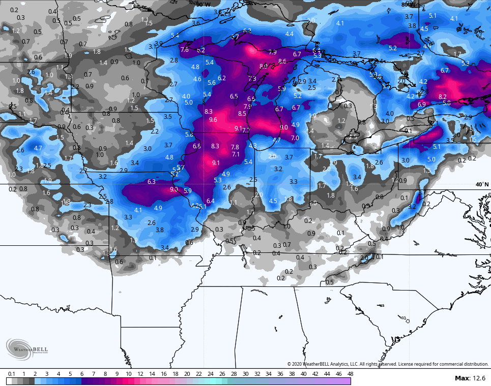
The NAM continues to illustrate what I’m talking about…
 Here’s the corridor of heavy rains…
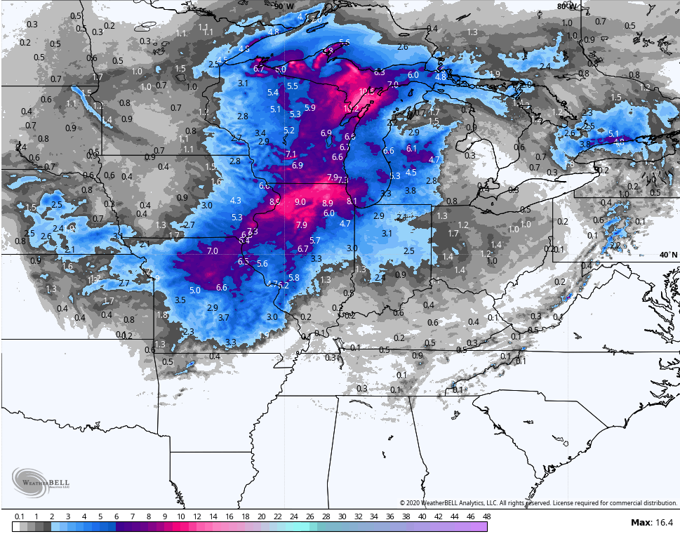
 The snow map from that same run…
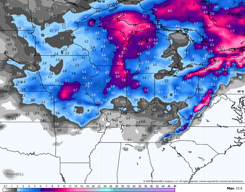
 The Hi Res NAM…

 The Canadian looks similar and then brings another sneaky little system in here for Monday…

 The GFS continues to be a lone wolf model with the entire setup. Soooooo.
This kicks off a very active southern storm track that will likely put us on the fence over the next few weeks. For winter lovers, that’s at least some progress from where we’ve been! 🙂
I will have the latest on WKYT-TV starting at 4pm then again on KWC this evening. Until then, let’s do some tracking…

Enjoy the day and take care.

It’s funny we finally had the cold but no advail as far moisture to play with to have snow. Then it warms up and we get yucky rain. This pattern will give. Up some day.
Yes, it will in February and March 2020 and maybe in April too. I will let everyone on the Blog know what kind of Winter we had on May first. LOL
Yeah, so excited, LOL! I don’t live in Central KY but the newer runs still have Harlan in the heavier rainfall too….LOL.
So, will this possibly be a third year straight of receiving a foot of rain in February? Chances are extremely low but the pattern screams wetter than average next month and crazy that I have seen back-to-back Februarys with over 12 inches of rain…super low odds since average is right at 4.10 in.
For Harlan:
Feb 2018: 12.24 in rainfall
Feb 2019: 12.83 in rainfall
Also interesting and areawide, both 2018 and 2019 started out around average to even below in a few areas for January then February through most months of the year went way above normal. So far, 2020 looks the same but maybe we want be extremely wet later this year?
Seems those snowfall totals on all models are getting more anemic each run. Seems my prediction from a few days ago that we would get few to no flurries by Saturday/Sunday might turn out to be correct.
Keep those ” Snow Shovels ” handy we are heading into our snowiest month ( February. )
Need the galoshes too for SE KY as February seems to be the new wettest month, at least down here anyways.
We need the rain too, as next summer will likely be very hot and dry. I will let everyone on the Blog know what the Summer 2020 was like on November first. LOL
Most of the Snowstorms that occur in February and March are not noted by Meteorologist until Snow starts falling in the Ohio Valley.
Really, anytime of the year. The blizzard of 93 was a rare example of one predicted fairly well on the models at that time but most didn’t believe it and still had “the under” forecasted. Harlan was suppose to get 10 inches the day before but ended up with 30 inches the day after.
That’s all the comments I can think of until we get that Major Snowstorm. When that happens, I will let everyone know on the Blog how much Snow accumulated in my backyard.
Like I said RIP winter….where is the snow
The season formerly known as Winter rolls on. I had a little snow mentioned in the weekend forecast a day or two ago. But that is gone now, as I expected. Now the 40’s and 50’s all next week. The last 4 years are some bizarre Groundhog Day like scenario keeps repeating.
Too warm! I uncovered my palms today…zero damage:)
Did CB make a Fencetucky reference. Fence means that the cold air doesn’t look to make it far enough south. The blog is mostly noted for central KY weather and to be on the fence up there means tropics with no shot down here. Fine with me though because spring time is my favorite time of the year. Can’t wait for DST on March 8.
Seems set like the past two winters: Cold is dry and warm is wet. Just let go of snow and embrace the freeeeduuuum!
I like it! Letting go sometimes is the only way to move forward. Eventually, we will get a snow hit and likely when the forecast doesn’t bode well and ends up a big over achiever. Most of the best snow storms are rarely predicted well anyways 🙂
Well no major snowstorms have been predicted over the past four years and no surprises has happened yet!!
But rain prediction has been spot on.
Ten days in the 30s and 20s for highs last January down here and looks like only going to be three this year. Looking at the monthly model forecast for February and it doesn’t have any day time highs below 40. Historically the middle of the month the highs go by the 50 degree threshold so spring is not far behind. Looks like 2/3 of meteorological winter gone bye and not even a threat of a snowstorm..
Choo choo!! All aboard the KWC Rain Train!!
How do you kids like the “new normal” winter!
Ain’t climate change fun!!
Bryan no such thing. as a new normal winter. This patter has persisted before so if you like it enjoy it. The old man winter will return mark my word.