Good Election Day, folks. It’s another day of very nice weather across the bluegrass state as temps trend even warmer. Eventually, the warmer temps will come with a price with scattered showers and storms on the increase. We could even be talking about strong to severe storms later Wednesday.
Highs today will range from 80-85 degrees as a warm front works through. I can’t rule out that isolated storm early in the north and east, but things look dry for most.
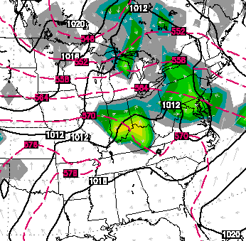
We head back into the 80s for Wednesday with a mix of sun and clouds and some thunderstorms developing. Several of the models develop a nice little cluster moving in from the north…
European
The Hi-Res NAM…
 That could produce severe weather across our region. Damaging winds and large hail look to be the primary players. I may update that threat later today.
A scattering of storms should hang around into Thursday as the front actually tries to push through here. That would keep our skies mainly clear into the beginning of the Memorial Day Weekend. It would also knock the temps down into the low and mid 70s for highs Friday and Saturday.
Memorial Day itself is looking much warmer as a ridge builds in from the south…
 That may also bring back the threat for a few storms. The same run of the European Model then says a familiar pattern develops by the end of next week with a trough returning…
That doesn’t agree with the GFS or the GFS Ensembles, so we will have to wait and see.
Have a great day and take care.

One word comes to mind with this type of set up… Starts with a D and ends with an O. and somewhat sounds like nacho!
Thanks Chris. Hoping that the rain will hold of after Wednesday as I have a long weekend. But the temps could bump up just a bit and I would not be upset, either. but I will gladly take some 70’s.
Hope everyone remembers to go vote today. Have a great Tuesday, everyone and thanks again Chris, for all you do.
It’d be a dream summer if we never reached 90° just like that one other year. A cool, stormy summer is perfect (in my opinion)
Pretty sure we’ve already hit 90 here in Louisville at least once this season.
I don’t think Louisville has ever had a year without hitting 90°. Louisville’s highest temp so far this year is 89° and Lex is 86°.
2004 with no official high of 90 in Lexington. A cool, wet summer for sure.
I’ve seen enough hot summers here now. A cooler one would be ok by me.
Agreed on the cooler summer. It’s only May 20th, let’s not go crazy yet with the predictions.
If you can noticeably feel the difference between 90 degrees with high humidity and 87 degrees with the same humidity, you must be a mutant of some kind. Professor X will surely be in touch soon.
After seeing 108 with humidity in St. Louis two years ago, I never want to see that kind of heat ever again. 😉
We have had several days of 90 degree weather had 87degree high today
Even with low humidity, I’m not a 90’s guy at all. Unless we’re talkin’ decades of time, I’ll take 80’s anyday…especially a warm, dry low 80’s with a breeze and partly sunny skies. Hopefully this summer will be like 2009. Loved that summer.
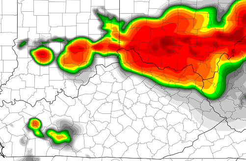
Surprised the SPC went with a slight risk tomorrow for such a large area, will be interesting to see what happens
I see where today’s Slight Risk area has been pared down (up?) to the North. Previously they had it extended all the way down to Cincinnati.
hate wind storms, plays havoc on the trees and gardens, just a good rain and thunder will be fine with me!
So far since almost a year ago Richmond has dodged bad storm after bad storm. I normally recall the last one, but thankfully can’t now. This has been a very wimpy rolling year as far as severe storms. Nice, but is there a debt we are building up with the misses? Hopefully mother nature is not an accountant 🙂
Bubba posting this time of year is Epic! 🙂
So if the pacific warms fast enough and el niño occurs early, this summer, our temps would trend a bit cooler right? However if it takes the pacific a bit longer to get its act together we’ll be stuck with above normal to hot. Do I have that right? Is that why it seems the models spit out differing long term forecasts?
The best way to handle severe weather is to be prepared to live after it. because you sure aint going to keep it from happening so worrying about it happening is a worthless waste of energy.