Good Friday to one and all. The much anticipated Memorial Day Weekend is upon us and the weather is looking pretty good to start things out. Scattered showers and storms may try to crash the party before the weekend is over. That could be the start of a rather stormy period as we roll into June.
Highs today will range from the low to middle 70s with partly sunny skies. Temps by the time we roll into Saturday will warm closer to the 80 degree mark as we hang on to the sunny sky.
Changes show up by Sunday as humidity levels start to really rise. This could lead to a late day shower or storm across the west and south. Highs will hit the low to mid 80s.
Moisture will really increase as we head into Memorial Day and that should help touch off more in the way of scattered storms. It’s a similar pattern that looks to carry us into the middle of next week…
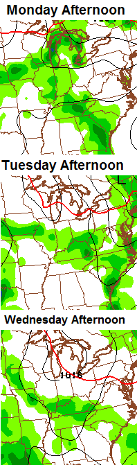
High temps during this time look to be well into the 80s with a very muggy feel to the air. Is this the beginning of a rather tropical and wet pattern that takes us into June? The latest 45 day rainfall forecast from the CFS shows some very hefty rain totals for much of the eastern half of the country…
 Certainly doesn’t look like the summer to be forecasting hot and dry!
Have a great Friday and take care.

“Certainly doesn’t look like the summer to be forecasting hot and dry”
Hallelujah! Don’t need a hot, muggy Kentucky summer. Had way too many of those in my lifetime. 🙂 (I know some will disagree)
Agree with you! Warm and wet is just fine!
Hopefully just not too wet. People with pools will want some heating to keep water temps comfortable. We had a nice little thunder shower here about 5:30 this morning. Garden variety, but did get some pretty good rain out of it. Thunder woke me up, but the rain lulled me back to sleep pretty quickly! 😉 Glad today is nice as we are going to decorate some graves. Thank you Chris for the updates and for all you do. Hope everyone has a great Friday!
That sort of precipitation pattern and the usual KY summer warmth, don’t buy into any idea on here that it will be anywhere approaching cool and comfortable, will mean we’ll have 3 muggy months instead of just the usual 2. Joy. Bring on fall already.
Patience, gr@$$hopper. 😉
MarkLex, in regards to your question last post. The autofilter in this blog automatically cuts off the comment if it contains something that it picks up as bad even if it’s within the word. Like if you try to write bluegras-s it will not post the comment. So I type it with a little dash or else you wouldn’t be able to see this comment and it would be removed automatically.
I have gotten into a habit of always copying what I comment just in case it wouldn’t post so that I can fix it, and try again without having to write a whole essay again. The longer the he comment the more likely it could contain a word that would need to be cut out.
It might not get hot and dry, but if its going to be wet their is no way around the muggy and that can at times feel worse than hot and dry!