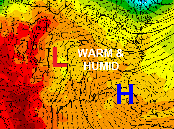
Good Sunday, folks. Our Memorial Day weekend has been great… so far. Warm and muggy air is moving in and that threatens to bring the weekend to a booming end. Once the storms move in, they are likely to stick around for a while as a touch of tropical air settles in.
We could see scattered showers and storms increasing today across western and southern Kentucky. Highs will mainly hit the low 80s. Here’s regional radar…

The warm and humid air will really increase into Memorial Day as scattered storms develop. Those storms look to settle in for most of the week as our flow comes from the western Gulf…
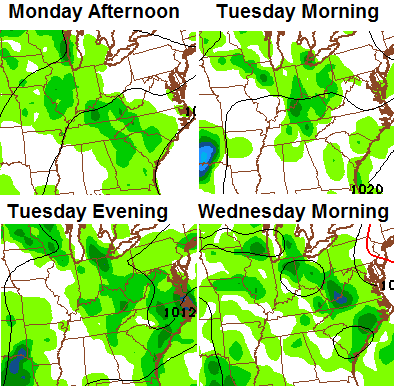
Take a look at the rounds of showers and storms we see developing…
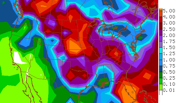
 There’s a small threat for strong or severe storms with this type of a pattern. The greater threat may come from heavy rainfall. This is something the pattern looks to be loaded with as we close out May and move into June. The 2 week rainfall forecast from the GFS…
 Have a great Sunday and take care.

This weekend sure has been great so far. I can’t agree more. I dread the tropical air flow. So was last summer considered hot and dry? Or was it warm and humid? I’m wondering if I have no real distinction between the two scenarios.
Yes, great wx the last few days, even if the radar is becoming more active this Sunday afternoon. This calm wx sure helps as the better half (wife) and I have made – and are still making – multiple road trips to see relatives during this holiday weekend.
At least in Nashville TN, last summer was near normal temps, but somewhat wet. Of course, there will be some variety in any individual summer and last summer we had some cool nights with low humidity and some moderately hot humid days as well.
In northern KY last summer was pretty nice. It only hit 90 a couple times (3 or 4) at the Boone Mesonet, and the max was only 91. We had a period in mid July with about 3 days around 90 and again in mid to late August with a day at 90 and several in the upper 80’s. Overall in the northern part of the state hot weather and pool lovers were not happy! I hate heat and humidity so I was quite happy myself.
here in our local area of huntington, wva the local mets are predicting around 20 90 degree days, 1 of which has already been recorded on the 13th if i can recall correctly…….imo…….there will not be 20 days of 90 degree heat…….it will be humid this summer with frequent bouts of thunderstorms that will make it feel like 90 a lot of times but the thermometers may actually only read in the low to mid 80s on any given day…….god bless.