Good Tuesday, everyone. We’ve made it through the long holiday weekend and its full steam ahead toward Summer. With Memorial Day being the unofficial kickoff to summer… it’s appropriate the weather is already acting the part with muggy conditions and some storms.
The stormy action is part of this steamy pattern. High humidity levels will combine with temps in the mid to upper 80s to give us a tropical feel to the air today. Scattered storms will go up and any storm that cranks could be strong and put down a ton of rain.

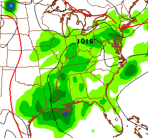
The flow of moisture from the gulf really kicks in on Wednesday and that shows up well when looking at a dewpoint map…

You can see how that flow is coming straight out of the Gulf and will lead to better coverage of showers and thunderstorms.
This similar setup looks to be around for the rest of the week and may hang around through the weekend. Daily highs will run in the 80s with lows in the 60s. That seems like a summer pattern to me. Something else that is trying to take on a summer look? The tropics. The GFS has been hinting at something trying to develop in the Caribbean for a while now…
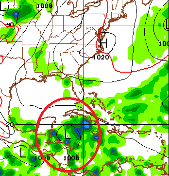 That could happen at some point next week or during the first few weeks of June. The Canadian Model loves to blow up tropical systems and it’s doing just that with this system as it takes it toward the Gulf Coast next week…

I guess we shall see what, if anything, happens with this system.
Make it a great day and take care.

I love daily scattered thunderstorms, gives me memories of the good times and weather in Florida where there would be 40-60% chance of rain everyday from June to August. Love watching big cumulonimbus clouds tower very high and watching the anvils of thunderstorms. The only thing missing is the heat, but I’m OK with that! (Also the sea breezes that would collide and cause HUGE storms with extremely heavy downpours. It was fun to predict those)
Agreed! I lived in Florida for many years and loved the afternoon storms to come and knock the heat of the day down. It made summers there bearable.
Yeah, I visited FL again a few summers ago and it was 92°, 70° dew point and calm winds. It was the exact same here in Lexington and Tampa but it felt hotter there and I noticed because of the sun angle, it was higher in the sky. The heat straight from the sun onto your skin is a lot worse there than here, sunburns are much easier to get there also.
The heat is missing??? How do you figure?
Floridians feel 80° as cool and anything below 70 is cold.
Floridians must of really hated this past winter lol
I think people that live in Florida become just like the reptiles that inhabit the state, must have heat to survive LOL!
Yea, reminds me of the winter of 2009-10 (?) which was so consistantly cold, the lizards in Florida were falling out of the trees!
All the wild American Crocodiles in the Tampa/St Pete area failed to survive that winter, pushing their range back further to the south.
You guys have no idea what I suffered when I moved from FL to Minneapolis, Minnesota! It was my first time seeing snow and below 28° temps. They called me lucky because I was there during the mild, non snowy winter of 2011-12, the winter that wasn’t. Then spring came the earliest ever recorded with the warmest March on record and the earliest 80° temp on record. I was apparently “lucky.” Average snow there is ~55″ and we only had ~23″. Then I moved here and was like this past winter was nothing. I’ve adapted fairly quickly to winters with snow now.
Thanks Chris. Hope everyone had a great weekend. Weather sure did cooperate at least for most. Don’t really mind the forecast as it is not full of rain and no sun. The scattered storms can put down some good rains in this setup. Well it’s back to work so have a great Tuesday everyone. Make the day count!
Dewpoint map? Where did you unearth this mythical creature? I honestly do not remember ever seeing one of these before on the blog in any of its homes. I’m sure you could quickly link to the last one you posted, so we could all know for sure. 😉
Dewpoint >>>>>>>>>> temp for living in the summer in KY. With every local station frequently rolling out new marketing terms for their weather coverage (NEW RAGNORAK SENSING OVER 9000 DOPPLER KEEPING YOUR CHILDREN SAFE FROM CERTAIN DEATH!!!!! RAWR!!!!), something which factors in dew point along with temp and wind would be incredibly useful.
A 90 deg, low dew point day with 10 mph wind is certainly a different environment to be out in versus a 82 deg. high dew point still wind day. I dunno, call it a “Livability Index” or run a contest to name it and score social media points or something. Or just wait until The Voice of Reason reads my post on here today and does it first.
Yeah, there should be a comfort index ranging from zero (nearly perfect) to ten (ugly!) So if it is 23° with 30mph winds and freezing rain, that’s a 10…….. 72° with sunny skies, calm winds—or 85° low humidity, breezy and sunny would be a zero……. This should be called the HCI—or Human Comfort Index. Today’s HCI is probably a 5? Feels humid and scattered storms so not the best day but ok.
My pepper garden really likes these temperatures, especially if we can get some nitrogen-rich thunderstorms (with no hail) to go along with it. I’ve already collected several gallons of rainwater for the garden. What a difference that makes compared to using plain tap or well water.
Sadly rain barrels aren’t allowed under our HOA 🙁
I know right! I’m sure a rain barrel would be much more attractive than my crumbling driveway!
Just a few lucky folks will hit the popcorn storm lottery today, wish it would be more widespread to knock the heat down for a while!
A near miss in east frankfort, Cinn area getting in on some good ones!
Our area is reaching a good mark climatologically, at least regarding tornadoes.
In recorded history, a May 28 1996 (tomorrow is anniversary) F4 tornado southeast of Louisville is the latest in the early part of the year for KY twisters stronger than F3/EF3. There have never been any recorded KY twisters stronger than F3/EF3 from May 29 until Nov. And no tornadoes stronger than F2/EF2 between about the third week in June until Oct. Tennessee is very similar to KY, except there is a single F3 in TN recorded in July. But in general, the stronger twisters this time of year are starting to migrate closer to the Great Lakes and upper plains.
It may seem counter intutive, but our summers have relative few twisters in the deep summer (despite all the t-storms) and those tornadoes that do happen tend to be weak. In contrast, while there are few KY tornadoes in January, a rare few of those have even been F4s!
So while we can still have issues during the summer with flooding, damaging winds, lightning, etc, at least the twister threat is starting to wind down a little.