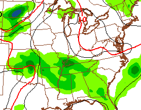
Good Thursday, everyone. Severe storms and flooding rains blasted much of the bluegrass state through last night. This action continues to diminish early today and will leave most of the state with much better weather. “Most” doesn’t mean “all” as scattered rain chances linger in the west and south.
The cold front is slowly dropping to the south across the region today. Cooler and drier air working in will mean highs temps in the 70s for highs with a mix of sun and clouds for central and eastern Kentucky. A shower or two will try to hang tough in the far west and south.

Friday looks to be another day with pleasant weather in much of central and eastern Kentucky with the threat for a shower or storm firing back up in the west and far south.
Highs will be back into the upper 70s for most areas.
We should hit the 80s on Saturday with an increase in humidity levels. That may spawn a scattered shower or storm late Saturday, but the majority of the action moves in for Sunday…
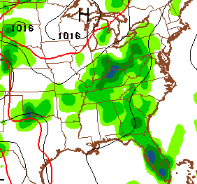 Heavy rainfall and strong storms will be possible during this time. The threat for scattered storms should hang around through, at least, the first half of next week. This will help keep temps in check with highs ranging from the upper 70s to low 80s.
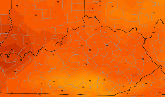
Here’s the European Model highs for Monday…
Have a great day and take care.

Well time to break out the water hose
Had .40 rain in east frankfort last night, I’ll take it, could use more but maybe this is a start?
I had .04
I didnt even get a trace of precipitation
Thanks Chris. We were fortunate last night as we did not get anything severe in our neck of the woods. We did get some rain though, and that is a good thing. We really needed it. And we have gotten a couple of showers this morning, so I am ok with that. I am glad things were not any worse than what I saw on the news this morning. At least, I didn’t see any reports of anyone being seriously injured or anything. that is GREAT news. Spseaking of great, everyone have a GREAT Thursday! Thanks again Chris for keeping us informed so well.
Just thought I’d share this week’s Drought Monitor that just came out a few minutes ago. Most of the D0 area was completely missed last night.
http://droughtmonitor.unl.edu/Home/StateDroughtMonitor.aspx?KY
This map should of added eastern Franklin Co. with some yellow!
Less than 1/2 in. of Rain in over two weeks!
It’s a beautiful day and I am grateful to not have to stand out in the gardens holding a water hose all day- it was getting dicey. The yard and woods look so happy this morning!
Wish I could have these temperatures all summer long 🙂
The models have been handling these weather systems very poorly of late. Showing lots of rain where little rain falls.
Agree!
Severe Thunderstorm Watch out for western Tennessee and far western Kentucky. Still, hopefully a little calmer than yesterday yet still getting some needed rains.
A quick dirty search of the web did not find anything yet about that reported mile wide tornado near Hopkinsville KY yesterday. Hopefully little damage and injuries. I imagine NWS Paducah will have a few storm surveys to do. If I remember right, Kentucky has never had a June tornado stronger than F3/EF3…..at least not in recorded history. So if this thing was an EF4, that would be a first.
If it was a EF4 we would of heard of significant damage reports by now.
So as of this t yping all the NWS in Paducah can find is straight line wind damage? That’s odd considering what was reported last night by storm chasers and storm spotters. Usually when a significant tornado strikes the NWS office will go in and rate and report the most significant damage then fill out the details. Here they’ve survyed a portion of the reported damage area and come up with straight line winds. We’ll see what they report tomorrow. Hopefully little damage and injuries.
The small drought in southeast KY isn’t a big deal relative to the drought in Texas…….It’s terrible in TX. I mean, has KY ever had a drought THAT severe? I hope they get tropical moisture or something. I remember one year hear it was TERRIBLY dry. I think it was 1999….it was a bad drought, but even in our worst droughts, it seems like we end up with more rain than they have had. I’m still amazed how much rain bluegrass apt got last night…….I fell asleep before the storm and checked this morning and saw almost 2 inches of rain……..I was so sure that we missed out on the storms and I feel asleep and missed them.
Texas and Oklahoma are semi-arid to begin with so they get a lot less rain annually and have adapted to handle the dry weather, all crops irrigated, large reservoirs for drinking water, etc. That being said, a multi-year drought of that magnitude is devastating, no matter what the climate. The 2012 drought was probably the worst drought in the western part of the state since 1936, intensity wise, but it was a quick hitter starting in February and was improving by September. Had it lasted into 2013 or 2014 it would be just as bad as what is happening in Texas. And for the record, that can happen here. Look up the 1954-1955 drought.
I just wrote a few sentences in a comment regarding the drought in Texas. I should have known better to waste my time, because anything over three sentences never posts for me.
When I’m posting a long reply here, I’ve learned to do a quick copy, so I can paste again if it disappears into oblivion. 🙂
But yall know why right?