Good Sunday, everyone. We have a busy week ahead of weather across the bluegrass state. A slow-moving upper level low will spin toward the region and that spells rounds of showers and thunderstorms. This doesn’t mean you won’t have plenty of dry hours, it just means we are going to be doing a lot of storm watching.
Low pressure is working across the state today and is spawning scattered showers and storms. This action looks mainly concentrated on the first half of the day with cooler and drier air working in from west to east. Temps today will struggle to get past the mid and upper 70s for many areas. It’s actually gonna feel pretty darn good for much of the second half of the day.
Track away…

Current temperatures

Monday starts nice with upper 50s to low 60s under mainly dry skies. That dry weather will slowly give way to showers and storms working into western Kentucky during the afternoon. This is ahead of a very moist flow ahead of our upper level low. Watch how slowly this system moves…
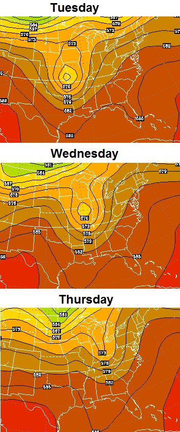
That will lead to rounds of showers and storms with dry weather in between. Locally heavy rainfall could cause some issues in a few spots. The temps during this time will be held in check. Highs should range from the upper 70s to low 80s.
The pattern continues to be skewed wet for much of the eastern part of the country. The European Model 10 day rain forecast…
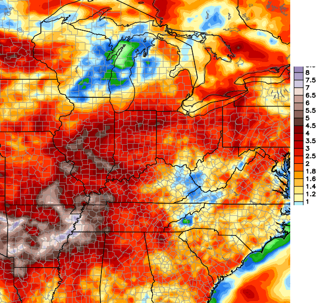 Just like in the winter… these are posted to show the trend and you shouldn’t take the totals as the gospel. Computer models are guidance and change from run to run. Look for trends, instead of focusing on exact numbers.
Have a great day and take care.

Maybe its just me, but it looks like the east stays drier. Don’t like the lesser amounts for the Appalachian region, like most everyone else on here, been overall rather dry over here in VA too. Hearing some farmers saying they’re struggling with their crops and not enough rain. The drier fall season will be here before you know it, hopefully we don’t get stuck in a drought trend.
Dry here. Part of my county had some flooding rain. Here, nothing. Looking at that rainfall map here we are in the up to 1 inch for the next 10. Hope it over achieves because it’s been dry enough I have not had to mow for 2 weeks.
I have tried to post several times in the last few weeks. But it never works. I live in southern Montgomery county right where dry is on the forecast map. We have not any real rain here since the first of May. In fact only .1 of rain since May 10th. We have drought conditions here. Sadly 2 weeks ago this county had flood warnings, and all surrounding counties had them too. But we never received a drop. Praying for rain.
Try to post short , not long…..(if you can)
My shorter posts always go through. But if I try to post something longer, it never goes through.
There are also many seemingly innocent words that cause the auto-mod to delete the entire post. Such as c*l*a*s*s (to my dismay, my posts about about SkyWarn weather spotter courses kept getting deleted until I looked at the last three letters of the word c*l*a*s*s).. Posts about D*i*c*k*s*o*n County in Tennessee suffered the same fate. So one needs to use different words or insert somthing like a ” * “between letters of the “bad” word.
A lot of people have this issue and can not help but hurt CB’s blog. There does not have to be questionable words or patterns to result in a failed post.
Sure the blog is popular, but perhaps less than it could be due to the phantom gate keeper troll, stopping posts.
Nashville TN has seemingly been on the borderline between wet to the west and dry to the east. We would get just enough to keep things green but not much more than that……..until the last few days that is. The main Nashville airport (BNA, on the east side of town) got 1.57 inches the other night, followed by about a half inch the following evening. So for the time being, the dry spell is over although much of the area continues to be in a mild drought.
my family will be in Nashville this week, we have never been there, what I have seen is a chance of rain everyday this week, hate to have a very wet vacation. what are the locals showing for the weather. Thanks for any info.
Looks largely wet, unfortunately. Personally, I watch Nashville’s CBS station WTVF.
http://www.newschannel5.com/
Great meteorologists, almost as good as Chris Bailey 😛 .
I’ve only lived in Nashville about two years now (I grew up in east Tennessee, my wife in Bowling Green KY). But it seems the tourists persevere in just about any weather conditions walking along Broadway, Demonbreun St, etc 😉 . Anyway, there are sights around downtown such as the Country Music Hall of Fame-Museum and Ryman Auditorium that are indoors.
thank you, Hoping it isn’t a total wash out!
For something other than country music (and if weather permits), Bicentennial Mall/Park is very informative and peaceful. My wife and I have been there countless times, both before and after we got married.
http://en.wikipedia.org/wiki/Bicentennial_Capitol_Mall_State_Park
I think the models need a reality check. 🙂 The trend has been dry over southeast KY. My parents live in the London area, and they’ve had to start watering the garden on a daily basis.
Per the Drought Monitor– http://droughtmonitor.unl.edu/Home/StateDroughtMonitor.aspx?KY — southeast KY will probably slip into moderate drought within a week or two if widespread rain doesn’t occur.
Drought is the trend, but not hearing much about it because the focus is always on the lucky few wet areas?
Are the wet areas few? Not saying they are not. It has been really dry here at my place. But my wife has relatives across the county and they all had rain. Seems just this area of the county has been dry with the storms just missing. Wonder how that is playing out other places.
Just from the mesonet I know where my mother lives they had almost 1.5 inches one day reported for her county. She had little rain that day. Another relative that lives in another part of the county had a lot of rain though. Thing is, if you get in these dry spots your county could be getting rain somewhere but you are not. Earlier this spring it was the opposite at my place. Most around the county were dry, even Mesonet only reported trace amounts. Here, man it poured. We were supposed to go to the park and meet up and let the kids play. We were not going to go so we called and they said it was sunny. This is a 15 minute drive from my place. Amazing.
Long post. I just am always amazed at how the weather works. Been interested since I was young. One of the most amazing things I have ever experienced was on the interstate. It was pouring the rain on the other side. People were pulled over even. On our side it was dry and sunny. You could literally tell the rain cutoff.
I see a lot of posts about lack of rain. Such is the luck with these storms I guess. Amazing that some places in a county can have 1+ inches of rain with pictures of the water running in the roads while other parts are dry. Tough to forecast. I know the mesonet had my county at almost an inch one day and we had nothing here. I literally went roughly 10 miles into town and there was water everywhere. Same issue for a relative of mine where they live. The north and eastern parts of the county was getting heavy rain and storms while their part of the county was dry. Although they have had a little more rain that I have here over the past few weeks.
Agreed. That is just the nature of these diurnally driven thunderstorms we’ve been having. One little popup storm can dump a huge amount of rain. Which means one community can be dry as a bone, and just a few miles up the road you can have flooding. It is dry at my house in Perry Co. I don’t think we’ve had an inch of rain total in the last month. The storms went all around us though, so other parts of the county are much wetter.. I’m not complaining at all, with all the dry days I have been able to stay ahead of the mowing.
Still waiting, hoping, and praying for rain where I live just north of the Somerset city limits. I’ve seen much worse, BUT it starts in a similar fashion. Chris, it wouldn’t hurt to mention done areas are abnormally dry now. Please don’t take offense, it’s not intended to be.
I hate it when trying to post while walking. I meant to say above it wouldn’t hurt to mention “some” areas are abnormally dry/entering drought conditions.
Another dry day in east frankfort, clouds with temps in the 60s, feels like September out their today! Hoping for rain in the coming days?
Made it to 85 degrees today in Knox County even some clouds today. I was really hoping on the rain that was in the forecast but as usual it didn’t.