Good Monday, folks. Showers and thunderstorm chances have been very common over the past few weeks. Some areas have quite a bit of rain, others have not. That’s how things go when dealing with summer storms. If you have been missing out, hang tough, you have many, many, many more chances ahead.
Those chances really ramp up from west to east today into tonight. That’s when a moisture rich system slowly works into the Mississippi River Valley. Rounds of rain and storms will work to the northeast over the next several days. Notice the pipeline of moisture aimed right into the bluegrass state…
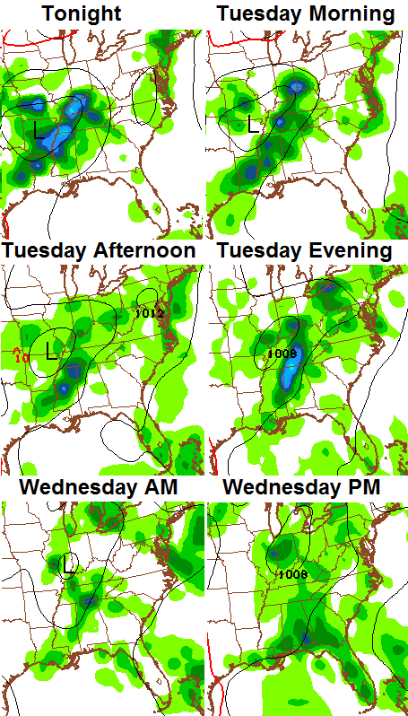
With that type of flow, heavy rain and a few strong storms will be possible. As a matter of fact, western parts of the state could see severe storms later today into tonight. That threat may move into central Kentucky on Tuesday. The Storm Prediction Center has this area in the slight risk during that time…

The area of low pressure will pull away by Thursday and that may give us a small break in the rain chances. That won’t last long as the moisture quickly returns for the weekend…
 Let’s track the action in from the west…

Have a magnificent Monday and take care.

Thanks Chris. Hoping the scattered stuff will hang to our south until we can mow the yard this evening. Guess we will see. Have a great Monday everyone.
Getting very dry here in knott co
“Some areas have quite a bit of rain, others have not. That’s how things go when dealing with summer storms”
Change “rain” to “snow”, and “summer” to “winter” and this starts to sound very familiar all over again. 😉
The Hamlin abides.
Just a week or so ago the models where showing flooding potential and heavy rains for most of the state, now alot of dry areas are taking over but the models keep preaching heavy rains, the models like in the winter are performing very poorly with location and amounts lately!
We’ve actually had many flood and flash flood warnings issued over the past week.
Just going by the comments on the blog those flood areas seem to be isolated compared to the dryer areas at the moment?
My part of Scott County is bone dry too. The creek behind the house doesn’t have a drop of water in it, we’ve mowed once in a month, and while walking yesterday I saw quite a bit of cracked ground. There have been a couple of 5 minute showers around, but the last decent rain was 19 days ago.
Im just west of you in eastern franklin co. And we have had .40 in. Of rain in the last 19 days, a drought is finding a way to prevail in the midst of a weekly rainy forecast??
I think we were supposed to be dry here in SW Ohio today but there is light rain being indicated on radar.
The Struggle continues.
Radar returns looking pretty anemic yet again today.
As CB has hinted, this could soon change. Hopefully without too much severe wx.
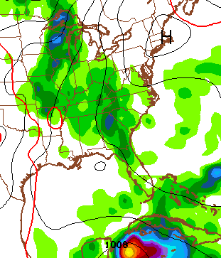
For now, the main action is to our west/southwest. Big bow echo t-storm presently in Arkansas with at least one Tornado Warning (a Tornado Watch for western TN, so far western Kentucky counties along the TN line could get some action).
looks like nice band of moisture along the Mississippi River headed towards the Commonwealth.
I hope it does not fade or split before it reaches central Kentucky.
A lot of Mets already forecasting much of this to fade by morning!
Struggling to cross the KY/Tenn boarder. It’s like it is being blocked by some sort of force field or dome….OH NO!!! Guess it isn’t just for snow anymore.
True “drought conditions” are not upon Kentucky yet. Compare this to August 1983, June 1988, August 2007, or Late June/Early July 2012 (just to name a few situations). It would take several more weeks of no rain to really bring a drought on. All those months I mentioned featured multiple days of 100 degree plus temps. Louisville, Lexington, Frankfort have not even managed 90 yet.
You don’t need high temperatures to create drought conditions. In fact, temperatures in the 80’s will actually lead to drought conditions faster than upper 90’s. When temps get too hot plants begin to slow down, or even shut down, reducing evapotranspiration.
I think you may have just misinterpreted his point. I think he was probably referring to the fact that it tends to get warmer in areas that are truly in a drought situation, as the waning vegetation and lower humidity allow temps to sore more.
So if we were really in much of a drought yet, we’d probably already have seen some higher temps to go along with it. That being said, too many factors affect temps to really use it as a reliable indicator either way.
My bad. You are correct, hot temps and drought often go together but aren’t mutually exclusive. Lots of factors involved in temps.
I don’t see the rain racing anywhere.
Look at the radar. Storm front tracking to the north east. In Tennessee now.
Wonder if the mountains will wither the front down?
Finally so eastward movement NJ ow if it just holds together