Good Thursday to one and all. It’s another day of isolated to scattered showers and storms across the bluegrass state. The bigger weather story in the short term will be the temperatures. We have a quick-hitting blast of cool before some very warm stuff. In the longer term… it continues to be about the abundance of rain chances and additional cool shots.
Temps today will head toward the upper 70s to low 80s for most of the state. Winds will be a bit gusty as a few showers or storms fire up.
Current temperatures


Friday finds a cold front crossing the state and this is likely to give us better coverage of the showers and storms.

Locally heavy downpours and a strong storm or two will be possible. Highs will generally run in the mid to upper 70s as the clouds and drops move through.
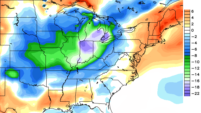
A shot of very cool air moves in behind this boundary to start the weekend. Lows by Saturday morning may dip into the upper 40s in a few spots. Look at the cool numbers from the GFS…

Check out how far below normal that is…

Pretty impressive to see that much real estate that far below normal.
Afternoon highs will be very pleasant with middle to upper 70s for most of the state. The nice temps should come with a nice sky with sunshine taking over.
Sunday will see temps back into the low 80s with an increase in humidity to boot. Thermometers early next week continue to warm and we COULD see some 90 degree temps for the first time this year. COULD is the key word here. The models have tried and failed to produce toasty temps on several occasions over the past month. The deciding factor on the temps may be the increasing potential for rounds of thunderstorms to roll in. That’s right… rounds of showers and storms will likely be around for much of the week.
Look what else may come back by the end of next week…
That’s right… another shot of cool air may engulf much of the region. This is a pattern that has not changed much from the one we’ve had since last fall. It’s seasonally adjusted, but the overall theme is very stable. We look to get frequent cold fronts moving our way through the summer.
That also means frequent rounds of showers and storms. The latest CFS rainfall forecast through mid July…
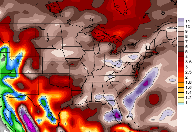
Again, the exact numbers and location will change from run to run. It’s the overall trend that’s key when looking at longer range models.
Make it a great day and take care.

I’ve seen a hot summer here so if this one turns out cool, I’m good with that.
Im dying to see someone say that Climate Change formerly known as Global Warming is responsible for this cool start to the summer.
I cannot say it is or is not. What I can say it that the key term is global. I have seen it be very cold here and the overall global pattern be warmer. In fact I think last winter was colder than normal here but the overall global temperatures where still up. I think through November last year 2013 was the 4th warmest year on record. Could not tell it by my place though. Still, we could be cooler than normal here and that have little impact on Global numbers. This is because the whole U.S. only makes up about 2% of the global surface area.
After seeing Matthew’s response, here’s hoping you are a man of your word. 🙂
The globe is bigger than your back yard
Yes it is and it is certainly bigger than man and some wacky God like idea that we are powerful enough to destroy our atmosphere and fix it with tax funded government special interest policies.. Hundreds of Nukes have been set off all over the world, if that didn’t ruin the global climate then no amount of industrialization we can do in the relatively short time humans have been industrious can destroy it.
We aren’t actually debating the veracity of climate change anymore are we?
As Matthew stated, “Global” is the key word. For that past year the Midwest and Ohio Valley have been the coldest spots on earth! The most below average country in the entire world for the bast year has been the US. We are always going to see ups and downs in a warming world. What you have to look at is the trend, the trend for our area has been up, like 99% of the world. The lower Mississippi Valley is the only place in the entire world that has been cooling ever so slightly with everyone else warming for the past century. Regardless, there is no doubt the world is warming as a whole. What’s left is to believe whether it’s human induced or natural. I personally believe it’s a combination of the two.
*PAST* Not that or bast
We believe that the Earth went through an Ice age, there is no reason to believe it can’t go through a warming age and no data presently suggests we are approaching apocalypse if we don’t funnel tax money to special interests and stop using naturally present fossil fuels.
We have already had several days in the 90s so this would not be the 1st time if it happens
Paducah has had the only 90 degree day of the year. That hit 90 one day earlier this month. No other reporting station across the state as recorded 90 or above.
I live in KY and i have had 90 degree days. It all depends on where you choose to get your information from.
I can place a thermometer in the sun and get 90 degrees right now. I get my information from reliable gauges such as the mesonet. Even the warm biased Lexington and Louisville airport thermometers have not hit 90.
There are 3 weather reporting stations that submit thier information to wunderground.com. 1 is the mesonet site and the other 2 are personal weather stations. The 2 personal weather stations have a aspirated radiation shield just like the mesonet site does and they have reported 90 degree days.
Argue if you like, but no one else will be claiming we’ve hit 90 in central and eastern Kentucky.
Just stating the facts. its no different than reporting rain or snow amounts unless you are at that person’s house it can’t be said if something did or did not occur unless you witnessed it. if it doesn’t go with forecast then its disregarded.
Have a nice day Mr Bailey.
Kentucky is a very big state. To claim that NO one (outside of the west) has hit 90 so far this year in the state is not good science simply because a couple of dozen reporting stations have not thus far. Once you enter southeast KY, with the ridges and valleys, microclimates become a factor. There are areas of upsloping and downsloping, both of which effect local temperatures. While I think it is a cool summer overall, compared to past summers, that doesn’t mean no one in central and eastern KY has hit 90 yet.
Not one single official reporting station has hit 90 degrees this year. No one keeps records of back porch thermometers or car thermometers. Why? Because they aren’t very accurate.
The facts are that not one official reporting station besides Paducah has hit 90 degrees.
Nice update Chris…lots of information there.
I kind of like this pattern when it’s “seasonally adjusted”.
Last summer there were 17 days of 90 or better in Lexington. First one was June 12th. 88 has been the highest so far this year on May 27th although there have been a number of days in the Mid and Upper 80s.
A ways to go but will be interesting to see how this moisture works out. If we can stay above normal for rain all summer and fall is decently wet as well cold help keep those temperatures down. Sounds nice to me.
Also, I wonder how this plays this winter. Will the cooler than normal hold out. With the moisture. That could make for a really fun winter. Might accidently slip in a real big event this year.