Good Sunday and Happy Father’s Day to all our dads. The pleasant temps of the past several days are now a thing of the past. It’s time for some typical summertime air to invade the bluegrass state. This will be complete with hot temps, high humidity and the increasing threat for showers and storms. Oh, I also have a little winter talk to cool you down. 🙂
Highs today hit the low and mid 80s with an increase in humidity levels to add to the sticky factor. There is the small chance for a shower or storm to go up, but most areas stay dry.
Monday will see temps nearing 90 degrees and that’s the theme of the week. How high the thermometer gets where you live depends on clouds and scattered storms going up. That is likely to happen each and every afternoon and evening. No, that doesn’t mean it’s going to rain on all of you, but the chance is there.
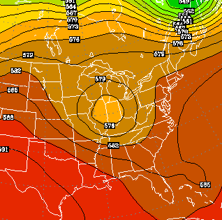
 The end of the week will find a slow moving upper low developing in the high plains. That will try to work toward the southeast into next weekend…
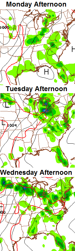
 Some of the models try to keep that around into much of the following week. That would dramatically increase the chances for showers and thunderstorms from late this week into the following week. That’s what the GFS has been hinting out for days and it continues to do so. Check out the 2 week rain forecast from the model…
 Many of you have probably been hearing about a developing El Nino. Some of have even tried to hype a “Super” Nino like 1982 or 1997. That is HIGHLY unlikely. We are likely to see a moderato to strong El Nino developing across the equatorial Pacific later this year. I’m already seeing people saying an El Nino means a warm winter for the US. That is 100% junk and there really isn’t any other way to say it.
Not all El Nino’s are created equally, but everyone looks at 1997 and 1982 to base every Nino forecast on. The placement of the warmest anomalies is a big player. When the warmer waters are along the coast of Ecuador and Peru, that tends to mean a warmer winter in our region. When those warm anomalies are centered farther west in the Pacific… it’s usually a cold signal here.
Take a look at where the warmest anomalies are forecast to be as we go through the upcoming winter…
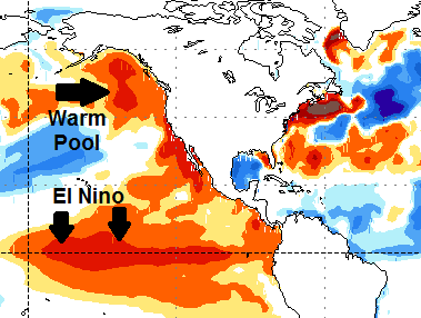 That’s right… the warmest water is forecast to be right in those areas that often mean a colder winter in the eastern part of the country. That map shows another big signal for cold in the east… a huge pool of warm water south of Alaska. That was the driving factor for the cold weather this past winter and is something I pointed out many times leading up to the winter. That warm pool helps promote ridging into Alaska and western Canada and that forces the cold into the states.
Keep in mind, the above map is only a computer model forecast and may change going forward. Still… it gives us a good idea of the overall setup of the Pacific Ocean temps.
Have a great Sunday and take care.

I cant deal with another winter like we just had.. Id rather deal with a winter that had lots of snowfall but was relatively warm… This past winter was just ridiculously cold and I can’t deal with that again.
The science behind the Polar Vortex may be interesting. Living it is another matter, though 🙁 . You know it was cold the first two weeks of this year when the train whistles sounded much louder and you were even feeling your nose hairs freeze 😉 .
At least we have fantastic weather, for the moment. Nice the give the ac bill a break.
“The warmer it gets, the better I feel” – that’s my new weather motto.
The thing was, while temperatures were below normal through the winter months it could have been even colder based on past history.
Sounds like somebody needs a good thunderstorm. 😉
I do… Its been more than 2 years since Ive had a decent chance to storm chase around here. Im going through deep withdrawal
Me neither Virgil. These ole bones hate cold winters. Thanks CB for all you do…
Appreciate it, Ben.
Thanks Chris. Happy Fathers Day to my favorite weather dude! Hot and steamy is normal for summer, right? And it “officially” begins next Saturday. So at least we are getting the correct weather for the season. As for winter, not ready to think about that one just yet! Have a great Sunday everyone and a happy Father’s Day to all my weather friend s out there!
Thanks Coffeelady!! 🙂
Happy Father’s Day!
http://i.imgur.com/g1PEohd.jpg
Creepy, but thank you. 🙂
Never to early for winter talk, no matter how cold this next winter is just the bring the snow 🙂
Oh, and happy Father’s Day Chris, you are the best weather dad we got!
Thanks, Todd. Hope you get some rain. 🙂
Crossing my fingers Chris thanks 🙂
It’s JUNE! Way too early.
You know a nice snow squall would feel good right now 😉
Happy Father’s Day CB!!!
Thanks, prelude.
Up to 89 from a cool 49 this morning. That’s an impressive spread..
Enjoyed my 3rd 90 degree day this yr
You just don’t let up do you pal? Gotta always try to prove you are right. Actually, you’ll find that few of us care. Chris has a wide, wide area to cover…don’t look foolish trying to nickle and dimne him.
He has a sad, sad life. Don’t let him get you down.
LOL