Good Thursday to one and all. Rounds of showers and thunderstorms are ready to kick in across the bluegrass state. These boomers will put down some needed rainfall in the coming days and will also help knock our temps down several degrees.
The storms will likely work at us in clusters from the northwest. Some of these clusters may be strong or severe. The worst of the storms could produce damaging wind and large hail. We must also be on guard for some high water issues. There is a ton of moisture available to unload on some areas.
I have your one stop shop to track today’s storms…


Low pressure looks to work across our region from late Friday through Saturday. That will help aid in the development of additional showers and thunderstorms…
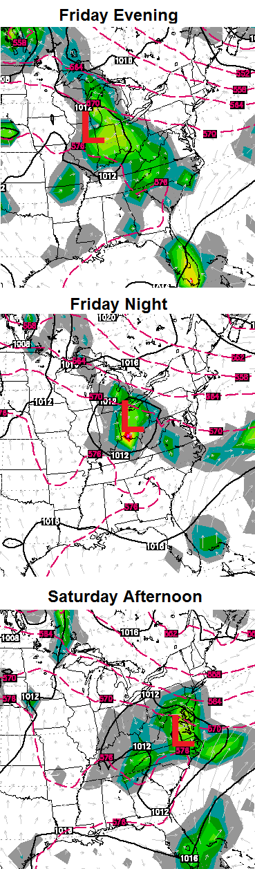 Heavy rainfall and some strong storms will be possible from Friday into Saturday. The cold front sweeping in looks to slow down, keeping scattered storms around this weekend into early next week. That’s when another low pressure scoots into the Ohio Valley…
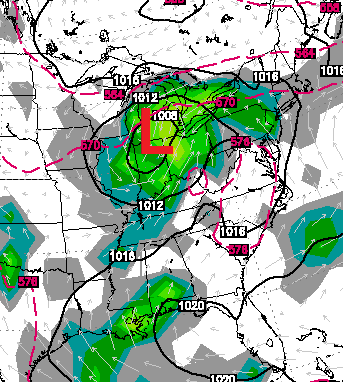
That means we are likely to see scattered storms around for each and every day next week.
Make it a great day and take care.

Thanks Chris, the rain chances sounds good to me and my tomatoes 🙂
Slice them up, add some pesto sauce and cheese then bake in the oven. Fantastic!
Yum!
See I am really a good guy despite what some think. 😉
It’s all good, this a blog that has interesting weather conversations and other topics, some folks are just a little sinsitive, I enjoy all comments even if I don’t always agree with them!
the storms are firing much further south than expected so far, hopefully northern and central can get something today??
Louisville for the fourth day in a row has cracked 90 degrees its officially 91 degrees. Starting to get dry in the Louisville area along with others we could use a good soaking storm.
Many yards in my area are brown, its getting extremely dry in east frankfort, this higher heat has advanced this quickly, Chris says most areas should get 1-2 inches of rain the next few days!
the only water coming out of the sky here in Louisville, will be from my sprinkler.
rainfall maps have recently been inaccurate in my hometown.
the radar does not look promising again today.
we play for another day.
A good little thunder shower in the hood, very heavy stuff hanging just north of east frankfort, I’ll take what I can get!
Drove through a very heavy rain coming back from Morehead. Not 8 minutes from my house was still raining. At my place nothing. Everything was dry :(. Hearing the thunder though so I am holding out hope.
What a mess in South Lexington. I had a late meeting with a client and the power went off over in the Fayette Mall area. Versailles Road had standing water when I drove out heading back to Woodford County.
Wow what a ride! From my clear memories of storms, this very small storm that expanded here in Lexingtion REALLY packed a punch. This has to be one of the worst storms I have been through, (I am young though) and it definetely qualifies as the worst storm I’ve been through for the past 6 years for sure. It has been the first time I have EVER seen hail before, hail was pea-sized though. the winds were at minimum reaching 50mph and the rain did NOT stop for over an hour to two. My rain gauge has picked up around 2 and a half inches of rain! As i am typing a second storm has just formed on top of me and it’s pouring badly again, I am right in the middle of the flash flood warning box, good thing I don’t live in a flood-prone area, i live in a more elevated area. Stay safe everyone!
Didn’t even get the ground wet on the west side of Georgetown. Lots of thunder and lightning but no rain.
had a good heavy rain and lots of lightening and thunder. a lot of people were out of power earlier in the Flatwoods and Bellefonte area. some have it back on now. wind wasn’t to bad but the lightening was awful ! Lots of trees and power lines down!