Good Friday, everyone. We’ve made it to the end of the hottest week of the year, so far. Scattered thunderstorms have been common in recent days and that action will increase today. This is when a cold front approaches the state from the northwest. It’s the first of two cold fronts I’m tracking over the next week.
Today’s showers and storms will have a lot of moisture to work with. That means heavy rainfall is something that could cause some issues in some areas. In addition to the torrential rains, a few storms may be on the strong side…


Our cold front will actually cross through the state on Saturday with additional showers and storms possible. We may get this front to sag far enough to the south for a decent weather day for Sunday.
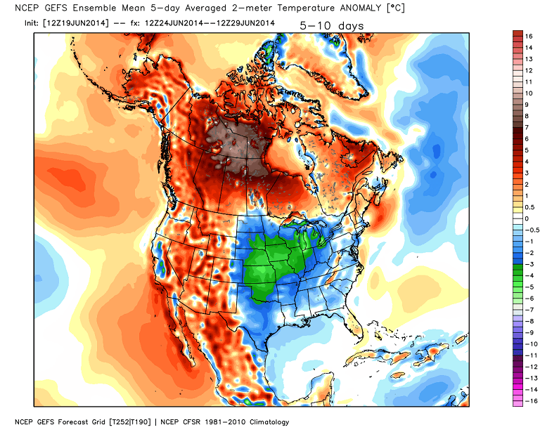
Another surge in temps, humidity and storms will swing back in for Monday and Tuesday. These storms will increase ahead of another cold front that arrives by Wednesday or Thursday. This one packs more of a cool down. Check out the 5 day temperature departure from the GFS Ensembles…
 Bring it!
Enjoy your Friday and take care.

I’m in northwest Lexington and not very far from KLEX, and usually get what they get, but not yesterday…
There were some really close lightning and loud thunder but the very heavy rain missed me. But I’m ok with that because we are one of the spots that has had decent rains recently.
Got about 5 minutes worth of rain here in Carrie yesterday evening, not enough to wet the dust, hope we get some good rain today and tomorrow
1.0 inch of rain in east frankfort last evening, some spots in Franklin co. Got Alot more but I’m not complaining, hopefully widespread rains get alot of dry folks today!
https://kyweathercenter.com/wp-content/uploads/2014/06/GFS11.png
-0.75 degrees from avg. Time to break out the blankets!
The more important question, will the air be noticeably drier or not when the temp goes down?
Give me 80s and low humidity anytime.
I hope the rain line in southern Indiana works its way towards Louisville.
it has been dry in my neck of the woods.
Louisville as of late has been unlucky in the rain department. Today is our best shot on some much needed rain hope it pans out.
Finally getting some good rain here in Carrie
Looks like a line of storms trying to form in southern Indiana, moving more east than south east at the moment, hopefully this fills in and gives all of ky a good rain?
Looks like I’m not the only one been left out with the rain. Haven’t seen any since early last week and that wasn’t much. Just got a new metal roof and I want a good storm to hear it!
I also think today is our best chance for rain, at least for Valley Station, just southwest of Louisville.
I thought more of the state would have been in at least the abnormally dry category, according to the most recent drought monitor update….
SW Jefferson County didnt see much action missed out again.
Just now got to look at the blog! What a busy workday it has been here! Looks like storms are a poppin’ all around/ and we just may get in on some of them tonight. Last night, we got quite a light show from the Storm over Adair County about 11 PM. WE are more than 40 miles away form there and the lightning was like it was right on top of us! High cloud tops and near continuous lightning in the clouds. It was a beautiful sight to see.
Thanks Chris for all you do for all of us weather weenies. You are appreciated more than you know! Have a great Fri day and weekend, everybody!
Late day here at my office, and now getting clocked by a good t-storm here in Nashville TN. Severe Thunderstorm Warning now in effect just north of Nashville.
A nice rain here on the Kentucky River in Woodford County. Some thunder but haven’t seen any lightning and the wind isn’t too bad either.
Severe storm damage in my hood in east frankfort, trees down, power out, roof damage , small tornado maybe??
Wkyt news just interviewed me and the wife on the storm damaged hood, don’t make fun if you see us on the tube lol
Awesome! Just saw you guys. Glad to have a face to go with your reports. 🙂 You did great!!
Thanks Chris, I’m better off camera 😉
Todd is now a blog celebrity 🙂
Not really, your stats are hall of fame! Thanks anyway!