Good Tuesday evening to one and all. The threat for severe storms will be pushing into western and northern parts of the state later this evening and overnight. Thunderstorms are blowing up to our west and a few of these will rumble their way into the state.
The Storm Prediction Center now has a good chunk of the state in the risk for severe storms tonight…
Track the boomers into Kentucky here…
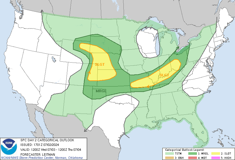
A better threat for strong or severe storms will be with us Wednesday as a cold front settles southward into the state. If we can get a few breaks in the clouds… look out… damaging winds and hail would become a very good bet with any storm that goes up. Here is the threat map from the SPC for Wednesday…

I will have updates as needed. Have a great evening and take care.


Good evening, Chris! Where have you been? I was getting worried about you!
Looks like we are in for some stormy weather….Hope they don’t get too bad.
Today was a beautiful day here. got kind of warm, but still low humidities, so I am not complaining.
I know you will be keeping us up to date, so, thanks in advance!
bring on the rain, h20, liquid snow,manna from above!!!….SEND THE RAIN!…LOL….:)
OH PLEASE please PLEASE let that activity hold together and roll through KY like a freight train!
I dunno. I always hear the cloud debris keeps the severe weather at bay, which makes me ask, “why is there never any cloud debris in the plains when the storms blow up from previous storms?”
Seems like it is hitting the river and falling apart…at least at the moment. 03403
Hi, man! I’m completely accede to your way of assessment and all of joined.
gjx x ibepw