Good Friday, everyone. We are rolling our way into the final weekend of June and it is looking like a rather stormy one across Kentucky. A plume of tropical moisture is working across into the region and this will help ignite widespread shower and storm action.
The muggy factor is back again today with highs into the upper 80s to around 90. Thunderstorms will become more common across the west and south with scattered action in the north.

Watch the increase in the coverage and intensity of the rain and storms over the next few days…
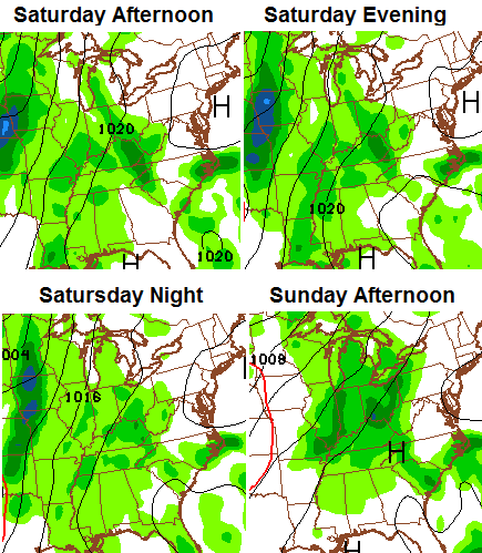
Heavy rainfall will be a good bet and some local high water issues may occur. Highs will generally run in the 80s with the tropical humidity continuing.
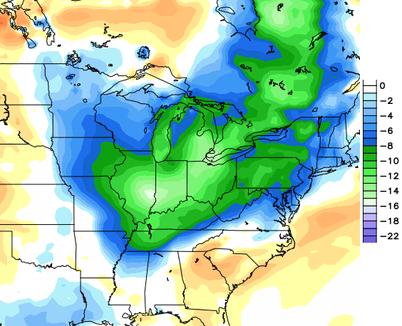
Additional rounds of showers and storms will take us into early next week as we await the arrival of a cold front dropping in from the northwest. This front may touch off a healthy line of storms as it rolls through here around the middle of the week.
The models continue to insist on a shot of cool air coming in behind it for the 4th of July. The European Model has been showing this for a few days and the GFS agrees…
 Enjoy your Friday and take care.

Cool and wet. Keep it coming. Woohoo
90 with high humidity is cool??
Im not real sure where Beth is located in KY but she’s been wet and cool since late May and the rest of us have been warm to sometimes hot and sticky. Things that make you go hmmmmm
I’d say a reasonable guess as to a living location would be under a bridge.
Whereas some live in ivory towers. 😛
I was thinking a cave its always damp and cool
Hot and extremely dry. There, I fixed that for you.
I will take a cool down for a few days, but I gotta say, this weather has been fantastic for my garden! sure I may be watering more than last year, but I will be picking a good 2-3 weeks earlier than last year!
tx Bailey Boy!!!
Still hoping that the race can go tomorrow night. Maybe the showers will get in and out long enough for them to run. Thanks Chris for always keeping us updated. TGIF, as I have contracted a raging sinus infection. Wouldn’t mind seeing a bit of rain and a day or two of cooler temps. Everyone have a great Friday! Thanks again Chris for all you do!
These showers that are popping up are not moving at all, some folks will get Alot of rain, most will get nothing!
Rain will be good on my tomatoe plants. Only got 9 and got late start then.
Thanks chris.