Good Friday, folks. The gorgeous, boring weather rolls on into the start of the weekend. This nice stretch of calm has allowed your friendly weatherdude to concentrate a lot on the coming weeks and months. What I’m finding is very, very interesting for winter weather lovers.
I will talk more about winter in the coming days, but today I want to focus more on early October. This is when we start to see some real changes showing up in the overall pattern across North America.
After a few showers roll through late Sunday and Monday (highest chances south and east), October looks to come in on a windy and warm note here in Kentucky. That tries to change in a hurry thanks to a powerhouse of a cold front that pushes in by the end of next week. The European Model has a classic fall front…
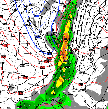
The GFS says “I see it too”…
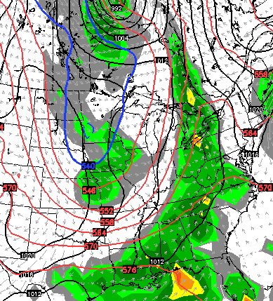 That could be a big rain and wind maker as it rolls through here and would introduce a pretty good chill to the region. I’m still thinking that model is rushing things by a few days, but we shall see.
The European Ensembles continue to unload a couple of deep troughs into the second week of the month…
 I will talk some winter over the weekend so check back.
Have a great Friday and take care.

Good morning Chris. I have a very special event coming up on the 4th of October and I am wondering if you can provide some detail in the coming days about the threat of rain for that day. My son is getting married that day, and we have worked tirelessly to prepare for an outdoor wedding here on the farm. As of now, the 4th isn’t looking too good. Please do what you can, to keep us informed about that weekend. I appreciate your efforts. I follow this blog every morning, instead of watching the news. You are just more fun. Thanks, Jeff Masters
Hi Jeff. Thanks for reading the blog… much appreciated. Looks like a cold front arrives Friday with the threat for showers and storms increasing. Some of that may hang around into the 4th. It does look cooler.
I can’t believe how close we are to the cold and snow season. If we get an early snow, we could see our first flakes as early as a few weeks.
Chris, oct 4th looking ok? My son is getting ,
married that day. I am praying for a beautiful day.
Congrats. It looks like some showers and storms blow through Friday and Saturday. It’s all about the timing of the front.
Sending best wishes! My wife and I got married in Oct 2013. We chose October partly for the fall colors, partly because Oct tends to be sunny and the driest time of the year. At least in our case, we had fantastic wx other than being a bit windy.
Dryer ground skewing high temperatures more than forecast. Still no complaints here.