Good Thursday, everyone. A cold front is crossing the state today and is kicking up some more gusty showers. Colder air is filtering in behind this front and that’s a sign of things to come. Arctic air shows up next week as we flip the switch on a very early start to winter.
Today’s front will create wind gusts of 30mph at times as it screams through here. Showers will work across the region as temps drop through the 40s behind the front this afternoon.

Current Temperatures

Some of the late day and evening showers could have a touch of sleet mixed in. As colder air works in tonight, temps drop into the low 30s for many. That could set the stage for a few snow flurries Friday morning, especially in the east and southeast.
Highs on Friday will only be in the low and mid 40s for many. Skies become partly sunny with readings dropping into the 30s for Friday evening plans.
Another cold front arrives Saturday and looks similar to the one we’re dealing with today. A band of gusty showers will develop ahead of this boundary as winds crank up. Temps will tumble through the 40s late in the day and could be cold enough for a flurry in the east by Sunday morning.
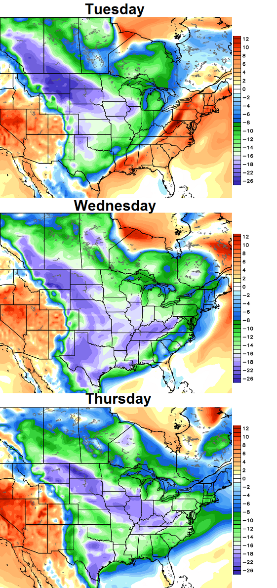
Next week is when the arctic express is due in town. Ironically, things start VERY windy and mild on Monday as we await the arrival of the arctic front on Tuesday.
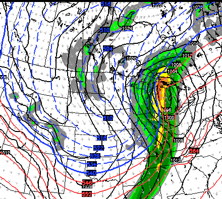
The Canadian Model shows this impressive system well…
The GFS has a similar look for Tuesday…

I suppose it’s possible for the cold air to catch the back edge of the departing rain shield and give us some flakes. The big story, though, is the cold. Temps may average greater than 20 degrees below normal for several days…
That is beyond impressive for so early in the season! What’s driving this? Check out the blocking across western Canada toward the North Pole…
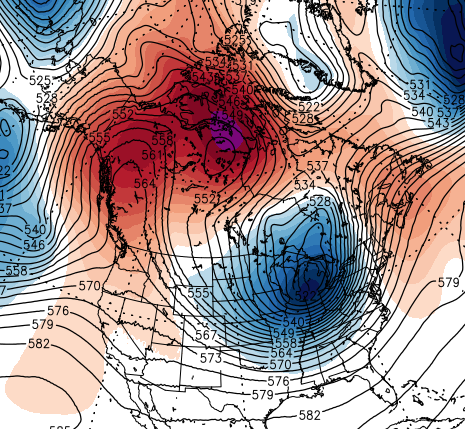
That allows for a mega trough to dig in across the eastern part of the country, and it’s loaded with arctic air. By the very end of next week into the following week, we will need to watch for something sliding east out of the southern branch of the jet stream. It’s a pattern that can lead to some winter weather to go along with all that frigid air.
Btw… the above pattern should be repeated several times over the next few months. 😉
I will update things later today. Have a good one and take care.

Looks like lots of cold but will there be lots of snow?
CB,
Twitter is slowly killing the comment section of the blog… Back in the day, there would be over 100 comments per post this time of year, but now everyone comments and sends pics on twitter, where it’s just more convenient I guess. (guilty as charged)
Keep up the good work my my friend.
I think once winter really starts heating up and a big storm is headed this way you will see 100+ comments again.
Hey bud! There’s likely some truth to that. You see how my twitter feed blows up nowadays and that’s an easier way for people to communicate with me and others. I also think a lot of the longtime posters stopped commenting out of fear of being harassed by some people who think this is Facebook or Topix and anything goes. I’ve tried to weed those people out. That said… the blog views are off the charts. Each month this year has doubled the hits from the same month last year. Take care, my man.
http://www.alexa.com/siteinfo/www.kyweathercenter.com
http://www.alexa.com/siteinfo/www.kentuckyweathercenter.com
It is growing and that’s good. Dat Bounce Rate doh.
As CB said, fewer and fewer comments. Comments don’t display by default, a second click results in a second page view being tabulated and increasingly the site is getting only a single page view, which means fewer people are checking the comments.
However, you have to understand that high comment totals go hand-in-hand with hyped events like storms, derecho, snow, etc. and really start adding up during arguments about whatever. Thus, the bounce rate is going to be skewed higher until we finally get some events worth discussing. Nature of the web and of people in general.
Btw, a mobile site that’s up and running would be nice 🙂
It’s very rare that I read this blog on a PC, I use my Galaxy S4 everytime.
I always read it on the computer and I check it twice a day every day summer or winter, fall or spring. I don’t comment often, but this is the only weather source I use.
I’d love to have an Android app for this site. I’ve checked it on my PC every day for years multiple times but It would be great to have an app. I’d even pay for it, be well worth it to me. Best source of info around, In my opinion of course. 🙂 I just rarely comment, just look & learn.
I am here every day more than once and I post fairly often if weather is happening where I am.I make a point to try and keep my posts weather related and not make it a general chit chat blog.Some days I don’t post simply because I have nothing to say weather related such as how much rain I received,etc.Its just an average day.
Other days I don’t post because I figure out which word I am using that is causing my post to be blocked.I usually try twice to edit out what I think it may be then give up if it doesn’t post the second time.
I’m sure the comments section will light up as soon as the first (big) snow storm is knocking at the door..
Yes it’s just because nothing horribly exciting is going on but also remember that people probably try to post and it ends up in never never land.
People don’t post anymore because certain ones bash others for having an opinion, not everybody likes snow/cold weather …. enough said !!!
Mr. Bailey, will you be putting out a winter forecast before it’s actually winter this year?
Always comes out the week before Thanksgiving. 🙂
Looks like an entertaining month! Definitely like the idea of the Lezak Recurring Cycle applied to this pattern. 😀
I have tried to break this comment subject down. So here it goes:
Since most comments in this post are about how little comments there are, here are the main reasons I found about why people aren’t commenting as much. (If i miss something, feel free to add)
Reason #1 (Main Reason): There is not a big snowstorm on the horizon to talk about. Winter-type weather just started and it takes time to build the viewers throughout fall and winter.
Reason #2: People don’t like to comment as much when much of their comments land in cyberspace (i.e. comment gets deleted automatically by the autobot.) That would happen to me personally until i found out how to prevent it.
Reason #3: The Chain Effect. This is when nobody comments because nobody else is commenting. Happens a lot, especially to me. I won’t feel like commenting because i don’t see any other comments. Once somebody comments, it breaks the ice, you’ll then see a lot of other comments throughout the day. (depends on other factors though)
And the twitter thing, I actually think it has brought more viewers and commenters to CB’s site because he tweets every post. It attracts more attention, thus more comments. But in general, its an upward trend since the past several years.
And I also forgot to add the haras-sment the has been on here before. All I have to say to that is be nice please. You shouldn’t bash on people just because of different opinions nor should you express them if it could offend people. This is Chris Bailey’s blog and I’m sure he’d appreciate it if you’d follow his rules. You’re awesome CB!
I enjoy eavesdropping on Chris’s Twitter feed and especially enjoy the pictures that are posted! I’ve been checking this blog routinely for years, since before Chris moved to WV, and I believe the comments have dwindled because of the sarcastic and hateful tone that was displayed by some during the last couple of winters. However, I think this is partly because the tone of those on the Internet in general has worsened. (Just check the comments section of any major news site and you’ll see what I mean.) This is still my first site to check in the morning and has been for years — thanks, Chris! You do a great job on here and on TV!
Brian Goode also agrees with it being very cold next week but it will be dry. Bad news for snow lovers.
I just now got around to checking the maps posted today.Been out trying to get warm,secure places fixed for my rescue pets I am caring for.Very glad I got on that task after looking at the maps and the forecast temps for next week.30s for highs ????
Knew it was suppose to cool but really wasn’t expecting that low for highs this fast.Thought I had an extra week.I think I was reading the timeline wrong the last few days.
Thank you so much Chris for all this information and especially the great details you post here.
I think Winter really is arriving this time around.
hey chris we miss you here in west virginia but i read your blog daily your the best weather man ever