Good Sunday to one and all. We have a busy week of weather ahead of us as arctic air takes control of the pattern across the lower 48. It’s a wintry pattern that will likely hang tough for, at least, the next couple of weeks. The cold is a given around here… snow is not, but we should have some chances.
The arctic front won’t arrive here until late Tuesday into early Wednesday. The slower timing of that will allow for temps to hit the 60s for Monday and Tuesday. Rain will increase from west to east during the day as winds crank up.
Wednesday will find temps 20-30 degrees colder than the day before, but the real cold arrives Thursday and Friday…
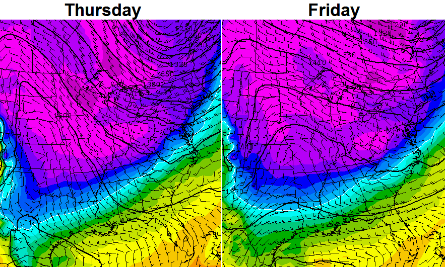
Highs both days should be in the 30s with lows possible dropping into the upper teens and low 20s. I say possibly because we will need clear skies for that to happen. There is still the chance for a weak system to bring some clouds or a few flakes our way by Friday. That looks like a low threat at this time.
The models continue to key on a potential stronger system for next weekend. Model deviations with track and strength are a given with any setup from a week away, but even more so this go around. It’s November and we have a very extreme setup across North America. The latest run from the European Model has a winter hit…
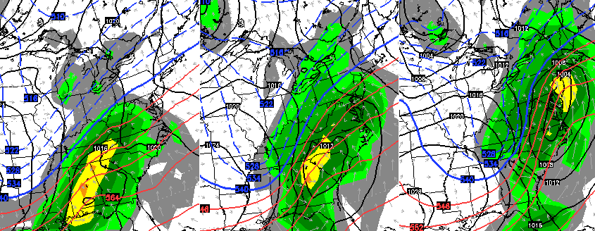
The GFS also shows the storm in question…

Again… track, intensity and impacts (if any) are a guessing game at this point.
Check out the air coming in behind that bad boy. -20c at 850mb is crazy cold for January and is nutso to see showing up in November.
As a matter of fact, the model runs of late have been the coldest I’ve witnessed in my forecasting career for November. Some of the numbers from the GFS go beyond crazy, but are fun to look at. Check out the lows behind the above storm…

The model then throws a couple of other winter systems our way. It starts Thanksgiving week with snow on the ground and these temps…

The chances of that actually happening are super duper slim, but I’ve never seen negative numbers show up on a model in November. Why am I showing that if it probably won’t happen? Because it illustrates how wild the pattern is and this is a weather blog. 🙂
Additional updates coming later today. Make it a good one and take care.

I love the snow but hell with it being super cold if we aren’t going to even get snow from it. Thanksgiving week seems like too long to wait for the possibility of snow.
Roger says you’re already complaining? I believe it was the late 1970s the last time we had snow on the ground on Thanksgiving. Any snow before Christmas is a bonus in Roger’s book!
Im just antsy for snow I guess.
I can’t say for certain about Lex/central KY, but we had snow on Turkey Day back in the late 90’s here in Nelson Co/Bardstown. The only reason I remember it is because it was the last T-Giving I spent at my (now Ex..) in-laws’..lol! My ma in-law hated me. Enough said. I think we got around 2″ that day, and “roads getting slick” was reason enough for me to leave her house & never return.
I’m AMAZED you were actually able to post that!!
WOW! Thanks for keeping us updated in Western KY (Cadiz,KY), I follow you for lots of weather information even though you are several hours away! Thanks!!!
Phew! That is one super cold stripe. Would be hard to enjoy the snow with negative temps (even though, like you said, the odds are virtually null). I’ll take 3-6″ w/ temps at 30 for 200, Bob.
You mean, Alex?
Whoops! Sorry. Meant Alex…
What a beautiful day, looks like tomorrow will be even better.
When will we be able to see the end of this November Polar Express? The models ever since last week have been forecasting this November deep freeze to be even more and more severe. The latest GFS and ECMWF models coming with highs in the 20s for a day or two sometime during next week. Heck, you saw the GFS going below zero in this post for the following week. Joe Bastardi’s saturday summary saying this will likely be one of the coldest Novembers on record. I mean, look at this!
http://www.cpc.ncep.noaa.gov/products/predictions/610day/index.php
http://www.cpc.ncep.noaa.gov/products/predictions/814day/index.php
As for snow, we have to get snow sometime with all this cold right? Next week looks very interesting….. Thanks a lot Chris, keep the multiple updates comin’!