Good Monday, everyone. The arctic express is about to pull into town and this will lead much of the country into an early season deep freeze. The big changes hit here during the second half of the week and will likely kick off a prolonged period of harsh weather across the country.
We have some very nice weather out there today so you may want to get out there and soak it up. Highs will reach the 60s on a gusty southwesterly wind with plenty of sunshine. Today’s weather is the anomaly of the month to date. It’s been a very cold November across our region. Many areas are running 3 to 6 degrees below normal…
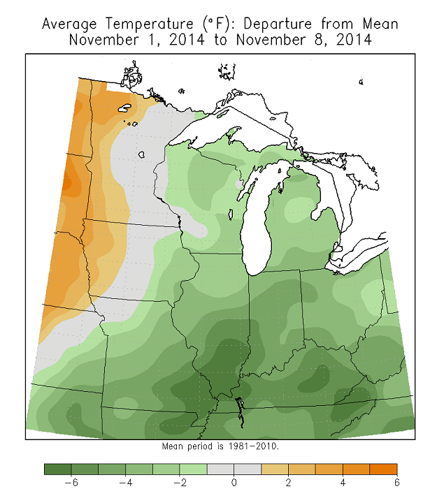
With the amount of cold on the way, this November may have a shot at being a top 10 coldest on record for parts of the state and region.
The arctic front delivering the upcoming cold will move our way late Tuesday into early Wednesday. A line of gusty showers will work across the state during this time as temps tumble behind the front. The really cold stuff won’t arrive until Thursday and Friday. Highs both days will struggle into the low and mid 30s for many with lows by Friday hitting the upper teens and low 20s. There is the possibility of a few snow or even a burst of light snow during this time as a weak system passes across the Ohio Valley…
A system will try to develop across the southwestern part of the country and roll northeastward. The models have been keying in on this system for the past several days. You will continue to see them wax and wane with track, intensity and impact (if any). The latest GFS still shows a shot of snow for us Saturday night into Sunday…

The air behind that is likely to be even colder for the first few days of net week.
The GFS then follows that up with another system working in from the southwest…

What may end up happening is a series of systems roll in from southwest to northeast from the weekend into next week. That’s a setup for us to keep a close eye on.
As mentioned, this is a very wintry pattern across the country and the action gets started today across the northern plains into the Great Lakes. That’s where a snowstorm could drop more than a foot of snow. How about a few live cams to get your winter juices flowing…
Minneapolis


I will have updates later today. Make it a good one and take care.

Aghhhh! I am so jealous of my relatives living in Minneapolis right now. I lived there for one winter and they had a wimpy twenty something inches of snow that year. And yes, 20″ is nothing, average is 50″ over there. they will also likely be going below zero later this week and well below 0 next week with the snowpack. The funny thing is… is that I know where camera #3 is at. I lived like a minute away from that camera. Heck, my old apartment I lived in could probably be visible in that camera in the background but because of the quality and visibility, its very hard to tell.
I spotted this oxymoron in this post “There is the possibility of a few snow or even a BURST of light snow.” That doesn’t go together does it? It just sounds odd. haha 🙂
I’m in Nashville, so I’m guessing no snow for us next week. But maybe a quick little snowchase to Bowling Green would do the trick?
Hey Cameron! WTVF said it’s a bit early to tell about snow chances, but as expected the Plateau may have somewhat better snow chances than Nashville. I suppose time will tell about Nashville, Bowling Green, etc.
I’ve been in Nashville for about 2 1/2 years now. I know Bowling Green rather well as I’m a WKU grad. My in-laws live in Bowling Green, too.
Hey TennMark,
I think going north before east when it comes to chasing snow. BG is a shorter trip for me, so I tend to root for them whenever Nash is on the borderline.
Louisville has not had a top ten coldest month since July 2009.
LOL! The ironic thing is I am now liking OPS (Other People’s Snow). For years we missed bigger snows and CB would put cams on showing OPS. Now that one son is in college and the other not really interested in snow, my perspective has changed.
All I see now is stuff to have to shovel with zero of the past sentiment. The irony here being we will probably get a bigger one now. With mainly the trend CB has noted and the irony, I am increasing the Bubba Buster potential to 60%. Normally it sits around 20% for a season. Sadly I also see ice having a shot- depending on how much the warm air tries to intrude.
Good to have ya back for another season, especially since I am now living in Richmond myself. 😉
Welcome to “The city across the river” 🙂
Even the Louisville Mets are saying this weekend could be a snowy one. Usually they won’t comment on anything that far out so that tells me snow could be a real possibility this weekend.