Good Monday afternoon, everyone. As we enjoy a gorgeous November day, arctic air and snow chances are about ready to blow into the bluegrass state. This has been a well telegraphed pattern we’ve been talking about for a few weeks now. The only question about it was… can we get some snow during this big cold snap? Well, that is a definite possibility this weekend.
We could pick up some flurries by Thursday and Friday as our temperatures settle into January levels. Highs in the low and mid 30s will be common with lows from the upper teens to low 20s by Friday morning. Winds will be gusty during this time and that will give us wind chills that are way down there early Friday…
I continue to watch a system rolling our way from the southwest this weekend. This has the look of a potential snow maker for our region. The GFS continues to show this possibility…

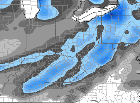
That is something for us to keep a very close eye on. As of now, the models keep this system from phasing into a big storm until it’s to our northeast.
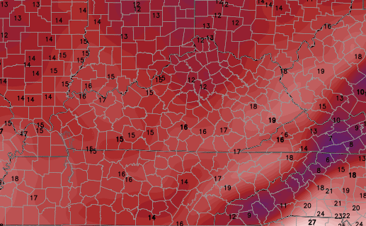
A colder shot of air sweeps in behind this system for early next week. Highs by Monday may not get out of the 20s for some. Lows Monday and Tuesday are way down there on the GFS…

It’s forecasting wind chills to be much, much colder during this time.
I will have another update coming later today so check back. Enjoy your Monday and take care.

Can we please have some positive news chris?some of us are trying to stay positive ya know.
This is positive for snow lovers. Snow, yeah, way to go!!!!
What a beautiful day we’ve had today! Got up early and drove to my destination along I-64 in the Morehead area and really enjoyed the scenery lit with bright sunshine. Just now finished a 21/2 mile walk without having to wear a jacket and the sun sure felt good. For November, you couldn’t ask for better conditions. I hope tomorrow’s weather is a carbon copy of today’s ’cause we all know what’s on the way. Knowing what’s about to happen has helped me to get out and enjoy the calm before the storm.
Thanks Chris. Wow! I know two or three of my last comments have said that, but, I really can’t think of another word to describe it. If we only get the cold, that is brutal for this time of the year. Guess we will have to just hang on and see what happens. Already starting to dig out the long johns and winter duds in anticipation of the football game on Saturday. Have a great Monday everyone.
I’m with you Coffeelady! I work outside most of the day and I’m gonna have to scramble to get my gear all ready.
I’m not complaining though, bring the SNOW & COLD.
Hoping this is a memorable Winter around here.
I’m trying to remember November being like what is forecast. I can’t.
I remember having an ice storm Thanksgiving ’76 or ’77 back in western NC and the power went out during dinner, but it’s such a blur because I was only 4 or 5. Other than this, I don’t remember anything too extreme.
November snow is a bonus! I’d be very pleased to see some fluff this weekend. Roger likes it!