Good Tuesday, everyone. A HUGE weather change is blowing across Kentucky in the form of an arctic front. This front is ushering in an early season extended period of cold weather. As I’ve said, it’s a pattern that looks straight out of the heart of winter.
Let’s start with today’s front and take it from there. The temps will be the big storm of the day as we may end up with a 30 degree difference from west to east. Parts of eastern Ky may hit 70 this afternoon as the west drops through the 40s and into the upper 30s. That drop in temps will then work eastward along and just behind the front. A gusty line of showers will accompany this front…
Current temperatures


Colder winds will then blow overnight into Wednesday. Most areas wake up to upper 20s and low 30s with a recovery toward the low 40s. The real cold arrives Thursday and may bring a few snow flurries with it. Highs Thursday and Friday will likely stay in the low and mid 30s. Lows by Friday may drop all the way into the upper teens and low 20s.
From that point, it’s all eyes on the potential for some weekend snow. The models continue to advertise a system coming from the southwest and skirting by to our south and east. That’s usually a good track for some flakes around here. The recent runs of the GFS are pretty bullish on the potential for snow around here. Here’s the current version of the GFS…

Here’s the snowfall forecast from that run…

There is a new version of the GFS that’s set to take over from the current model. It’s running as a parallel version until it fully takes over later in December. Here’s what it shows…
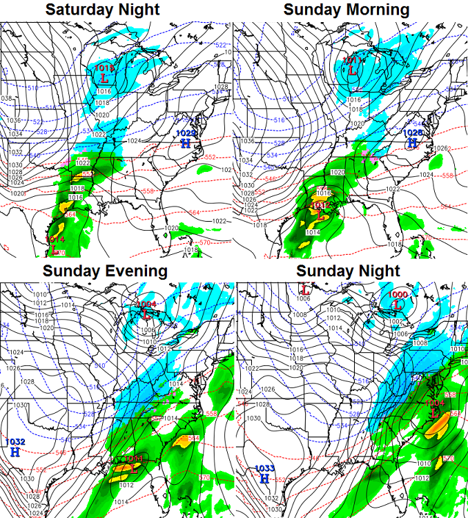

It offers up a similar solution to what the current GFS shows. Notice the increased resolution in this model run compared to the “old” GFS… it really shows up with the snowfall forecasts. Speaking of those snowfall forecasts… they vary greatly from run to run so don’t get too attached to them. 😉
With both models putting snow on the ground, they are also going to show some very cold mornings that follow. Here’s the soon to be “old” GFS…

The newer version looks even colder…
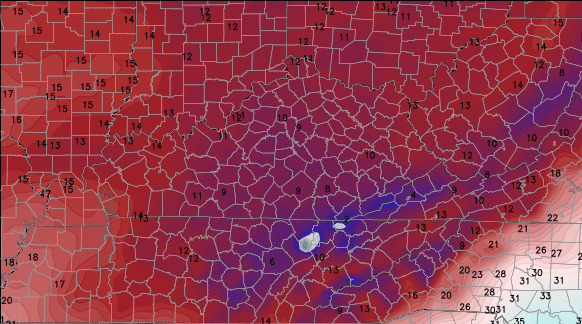
In order for temps to get THAT cold, you would definitely need snow on the ground. That is most certainly NOT a given, so let’s not get too far ahead of ourselves. It’s only Tuesday and we have a lot of model twists and turns to go through before the weekend. As I’ve been saying, the cold is a certainty, the snow is not.
Still, we are tracking the potential for winter weather way earlier than we normally do.
I will update things later today. Have a great day and take care.

3-5 inch snow for Sunday into Monday, this system going WRAP UP into a decent event. my opinion
And all the teacher’s ears in the room are perking up at the thought of a snow day on Monday….ground likely too warm, but it’s a fun thought. Have a great day everyone!
Bring on the snow!!!!!!
The chance is there. That would be trippy to possibly maybe have a snow day this early.
4 hour time lapse from Boulder, CO yesterday
http://i.imgur.com/CvPL1pb.jpg
As for us, well, all of this “potential” needs to get itself an 80s style training montage and get it together before The Dome whispers, “I must break you”.
I’m a snow hater so let’s not even talk about snow.ok?
Then you should probably avoid this blog for the next 4-5 months. Just sayin’.
Word. This blog will drive you crazy if you rather live in Florida. Just lookin’ out for your best interests.
Who are either of you to tell him not to post here?
Wow. Easy now. 😉 I’m not telling anyone what to do. I was only saying (in general terms) that snow-haters will probably not appreciate the vibe of this blog, as it is pro-snow. I think most regulars on here can back me up on that.
Again, it was in the spirit of protecting interest. I wasn’t telling anyone to take a hike; however, I do think it’s wise for people to think twice about coming on here simply to wine & vent (Note: not saying this person is doing this).
But at any rate, there’s no need to take offense…and I’ll own the fact what my earlier post wasn’t communicated clearly.
P.S. Forgot to mention my use of ‘Word’ was not necessary (I’ll own that too). 😉
Along with Winter and the snow possibilities comes more comment activity. Along with more comment activity comes more things escalating waayy too quickly. I suppose it has begun.
Yes…fly away with me and don’t come back ’til April. Speaking of which…that’s when we’ll see 60 degrees again around here. Right?
Wow- a rabbit tracker this early? That would be something.
Old school!
Thanks Chris and posters!
Interesting that the ECMWF wasn’t mentioned here. I’m really hoping the Euro comes around to what the GFS is advertising, not the other way around. Like CB said, the GFS runs are way more bullish…but that doesn’t mean I’m rooting against it 😉 Come on, ‘merica!
Shew I’m glad winter is back! The blog is ALOT more active and fun 🙂