Good Tuesday Afternoon and a happy Veterans Day to all those who’ve served this great nation. Thank you for all you’ve done for each and everyone of us. The winds of change are blowing out there today as the much anticipated arctic front crosses the region.
This brings in much colder air over the next few days. The weekend snow chance still shows up very well on the models. The current GFS…

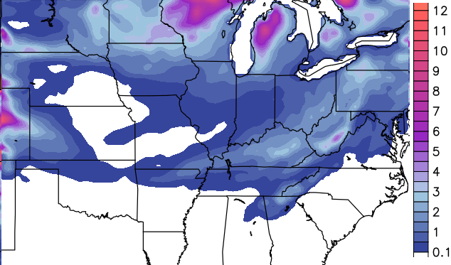
The high resolution GFS…


That model is a little more robust with the initial surge coming from the plains, but both continue with the overall wintry theme.
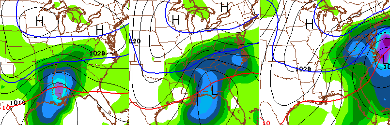
You’ve probably noticed I haven’t posted much of the Canadian and European Models of late. I mentioned a few days ago these would struggle and sure enough they are. Both have been jumping around much more than normal with what to do with this system.
All the models should settle down into Wednesday and Thursday. That’s when I will have a much better fix on the potential for weekend snow.
Regardless of the models, this system has been well advertised by the pattern for more than a week. The pattern is also advertising another system to watch for the middle and end of next week…
I will have another update this evening. Take care.

So, this latest model run looks a lot less potent on potential snowfall totals….. Either way, I much prefer any snow total over cold, bone chilling rains which was the dominant force here all last winter.
Wow, I go to the Bahamas for a few days, and all heck break lose. Our local Met calls for 3 chances of snow before the 20th of November! Seems like he thinks that there will be a greater chance of seeing the white stuff on Sunday. Way to kick off the pre holiday season! Count me in!
The latest GFS model run has gone bonkers for snow across Ky. over the next 10 days. Has around 30 inches for central and eastern Ky. Don’t think we’ll be seeing that much, but it’s fun to watch. Hope we get some of it though. Here’s to a nice, snowy, winter!
Can u please post a link to the site u get the amounts from. I can find runs of the gfs and nam but it only shows precip types, not amounts. I would appreciate it. Thank u
I tried, Zak. Posting from my phone and I couldn’t figure out how. Won’t have access to computer until later tonight. Will try then.
No problem James. I’ll check back tonight. I appreciate it!
http://meteocentre.com/models/get_accum.php?mod=gemglb&run=12&type=SN&hi=000&hf=120&lang=en&map=na
Hope that helps, Zak.
Yea. Thanks very much James!
Its 44 degrees in Crittenden County western Kentucky and 73 degrees in Lawrence County eastern Kentucky. Artic front is coming its like a train rolling hard, should be on the I-65 doorstep in the next few of hours.
Holding at 63 degrees in Valley Station. Front is just to my west. Will post a report soon when the bottom falls out….
CB just tweeted a few minutes ago that there was a 31 degree difference from Western Kentucky to Eastern Kentucky temps are dropping fast it’s now become a 33 degree difference from Eastern Kentucky to Western Kentucky
Temperatures have dropped 5 degrees within the past hour here in Valley Station.
Alanadale represent!
Not only did it get alot colder in the last hour, wind tore down my flag and dropped most of the leaves on the tree 8( Flag is rescued leaves can dry out lol.
PS Thank you to all the vets for allowing me to fly said flag in freedom!
Hear, hear! Agree completely with Candle. Eternal gratitude to America’s veterans. Thank you for your service to our nation.
The temps are holding in the low 60s in east frankfort, if nothing else these cold temps will stop the mowing until April 🙂
Just imagine of this happened during Thanksgiving week. Chaos it would be. Harrrrr.
It looks to warm up thanksgiving week but that could change
Thank you Chris for keeping us updated. Think winter everyone!! Well, maybe not ice storms. Think snow!! 🙂 Ready to hit the slopes this season!
I keep reading about the models having trouble dealing with substantially colder than average temps so early in the season, but maybe they don’t do so well with well above average ones either?
WKYT forecast high – 63
Normal high – 58
Mesonet high – 70 (Fayette and Madison) (locally higher)
I noticed last night that W. Ky had lower low temps and and low high temps today than the Eastern half of the state. You usually always see them being warmer right now, so that was unusual.
I can see our snow dome doing stretches and warm-ups, so that looks like good news for everyone else outside of Berea. 🙂
God bless all of our Veterans!!! You are so appreciated.
A station in Louisville has given a accumulation forecast Saturday night into Sunday getting 1 to 2 inches of snow (preliminary) subject to change.
So, what looks more promising in terms of snow/winter precip, Saturday into Sunday or Wednesday into Thursday?
A real Salute to all our Vets
I lost half of my comment can you do something about Northern Kentucky getting some snow at appreciate it I love it thanks Chris for all you do