Good Tuesday everyone and we give old man winter a big welcome back. Temps today are going to be quite a bit colder than the past few days and now we await the return of the little thing we call snow. We have certainly seen our fair share of it this winter and it looks as if we have a few more rounds to go before we can get to spring.
Today will feature mainly cloudy skies with a few flurries possible as temps stay in the mid and high 30s.
The action begins to crank up around here on Wednesday as an arctic front sweeps in here ahead of a VERY potent closed upper level low. This system will move through during the overnight hours Wednesday into early Thursday. This will bring widespread snow showers and squalls to the region. The best time for us to lay down accumulations will be during this time.
What happens from there? A blizzard is likely to rage across parts of the northeastern US for the second half of the week. Some of the models have been trying to pull this storm far enough inland which would mean some wraparound snows or northwesterly wind snows would be much more likely around here if this does happen. Regardless… this storm will be a monster…
NAM Thursday Evening
Parts of the northeast will be measuring the snow by feet with this kind of setup. This will be a headline making storm for a whole lot of people so get ready for the media coverage that will be coming this week. Crazy media people! ![]()
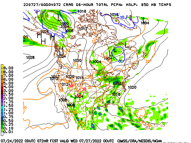
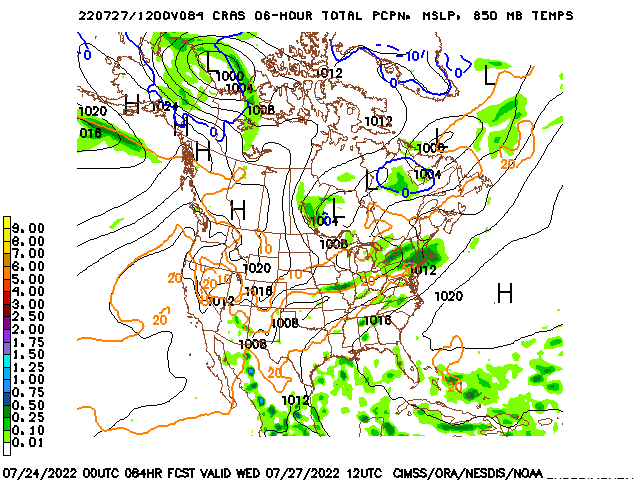
Almost all the models agree on the above scenario playing out. There is an experimental model known as the CRAS and I have posted it a few times in the past. It does not have a lot of respect in the weather community but I wanted to post it anyway as it shows a different solution with the blizzard. It is one that has a greater impact on this region…
Thursday Evening
Friday Morning
That is certainly eye candy and is almost certainly wrong. ![]() But it is a lot of fun to look at.
But it is a lot of fun to look at.
That brings us to the storm threat for early next week. This week’s storm will be a BIG event and that can sometimes have an effect on the systems coming in behind it. We will have to watch to see just how long this blizzard across the northeast hangs around this week. If it lasts into the weekend… it could force the storm early next week to go to our south. As is… the GFS Ensembles still like the storm threat…
I will get back to having more daily updates starting today so make sure you check back. Have a great Tuesday and take care.
Select Page
It is true, Winter is over, ring in Spring! I cant’t believe that places like Augusta GA and Dallas TX will have triple the snowfall for the Season than we got in Northern TN Southern Kentucky; this Winter was better than the recent past but still lacked alot; all I want is one old fashioned Winter, one where the places that normally get snow, get it and the places that dont like the deep south, dont!
I can’t believe that you’ve only seen 7 tenths of an inch of snow this year. You said that places like Dallas and Augusta have received three times what your area has and while Augusta has received 8 inches the NWS only shows Dallas with 2.2 inches total for the season. http://nowdata.rcc-acis.org/FWD/pubACIS_results Even the 8 inches in Augusta would mean that you have received only 3 inches if they have received three times your amount. I could be wrong but I certainly would have thought everyone in Kentucky would have received more than 3 inches of snow this winter.
sue– I have a friend in Dallas, TX and they had 6 inches of snow where she lives. I believe that the NWS has there measurement wrong.
I don’t know where that Dallas data came from, but they are officially over the 15 inch mark at DFW airport. In fact, it is their 2nd snowiest season on record. They just had a record storm total snowfall of over 12 inches this month!!!
Here is the Official link http://www.weather.gov/climate/getclimate.php?wfo=fwd
Besides a one or two inch events (perhaps two events), we are about done this winter. Head NE for the action. Even CB is saying this now (not to head NE, but that is where it will happen).
With the exception of a one in a million fluke, we be done mon’- Do the Bob Marley.
Heard that,,,I agree bout no big event for cky
man OLD SCHOOL GETTING CLOSER AND CLOSER, IT GOING HAPPEN FOLKS BY MID MARCH.
1987 IT HAPPEN IN LATE MARCH!!!!
I gotta feeling that East and SE KY hasn’t seen the last of old man winter. I bet these will be some of them there lingering snows like the last couple of times piling up to about 3 inches or so.
April 3, 1987, huge snow in Greenup County
Thanks Chris for the update!
I’m hoping the WARMER temps come back soon, I’ve been bitten by the SPRING BUG!!
WXman.. check out Mar 9 (6z GFS) that would be tornado alley for KY if that was to pan!
http://www.nco.ncep.noaa.gov/pmb/nwprod/analysis/namer/gfs/06/images/gfs_ten_336m.gif
It won’t be long. The sirens will be sounding before we know it. Spring is just weeks away. Everybody should try to attend a SKYWARN class nearby this year.
I remember that snowstorm in Pike County, it caved in many homes, barns, garages, and destroyed my dad’s fruit trees (around 10) Somebody may correct me, but it was between 2-3 feet.
On a sad note.. my neighbor owned some classic cars. I remember 1 of them being a ’57 chevy. I can’t remember the other ones he had in the garage, but all of them was crushed.
My point is not found in the exact statistical amount of precipitation but rather the fact that snow is going all around Northern TN and Southern KY; dont be a barbarmonger
Dude, yesterday you stated: OLD SCHOOL IS COMING, I WILL NOT POST FOR 1 YEAR IF WE DONT SEE OLD SCHOOL late moneth early march…Now your saying MID MARCH…..come on, stick with what you say! is it late this month(this weekend-early march (beginning of next week) or MID march (around the 15th)???? That is a pretty big time frame.
The Bengals went to the super bowl in ’89…every year we can say well it might happen again because it did in ’89…yes they might someday, but chances are it hate happing–same with your idea of the BIG ONE in March!
Hey bernie…i follow the blog closely during winter months for snow days. I am getting to the point where i understand the snow stuff, but i am pretty novice for thunderstorms and tornadic action. Exactly what on the map tells you this is tornadic weather as opposed to heavy precip? just wondering… 🙂 thanks
Bengal anaology = sad AND accurate
Rolooooo! Not seeing it for us, but the NE US may want to keep a retainer on snow equipment;)
interesting twitter update from Chris about 7 minutes ago
When the models point to the juicy WARM air colliding with COLDER air associated with a strong low at 996MB, which in this case its showing it 6am (sun enhanced) would make it very potent for air forcing on the colder air tops as that particular frame shows.
Here is a good link to keep an eye during Spring & Summer, this will help show the areas of the greatest threat for severe weather.
http://www.spc.noaa.gov/products/
I wish he would be more specific on the areas he says it might get interesting in. Chances are it’s NE KY and not central.
moderation
When the models point to the juicy WARM air colliding with COLDER air associated with a strong low at 996MB, which in this case its showing it 6am (sun enhanced) would make it very potent for air forcing on the colder air tops as that particular frame shows.
Here is a good link to keep an eye during Spring & Summer, this will help show the areas of the greatest threat for severe weather.
http://www.spc.noaa.gov/products/
hey bengal fan why dont u shut up and take a xanax so u aint so darn hTFUL buddy, early march/ mid march it dont matter if old schhool hits march 31st it well OLD SCHOOL.
some of u make me sick trying to be mean to some to cover up ur sad/miserable life.
You have a good point MikeM. I wish he’d be more specific at times as well. From what I can tell from some of these models (and I can’t tell much) is that we may get as much as 2 inches at best if that!
Bluegrass BuBBA has been whispering in Chris’s ear again…OH NO !!! I think he told Chris that a biggun’ was a comin…LOL…:):)
I don’t know whether to smile or frown…
Boyle County- A few snow flurries observed. 39*
Thoughts http://stormtracker.yolasite.com/
Rolo- I’m with ya, I would like to have a Old School as well,(don’t care if was here in July, BUT I just found it funny that you said its coming , but just kept pushing the time frame back,,,,Like I said earlier, Im predicting that my Bengals will be back in the super bowl,,,but really I don’t have A CLUE when that will happen–to many variables, to many trends that it hasn’t happen in the last 2 decades..same as the “old school snow” at least here in CKY!
Tim……..That’s two smiles!! Are you getting hopeful for more snow? LOL!
Wxman is that the same as a spotter and where could I attend one?
I am absolutely amazed at how terrific the stuff is on this site. I have saved this webpage and I truly intend on visiting the site in the upcoming days. Keep up the excellent work!Deliver flowers to Canada|Send Flowers to France
Tuesday marked [url=http://www.coach-handbags.me]coach outlet
[/url] the return to the bipartisan Senate group of Senator “>coach outlet online
Tom Coburn, a conservative Republican of Oklahoma, two months after he abandoned the effort by two other Republicans “>coach handbags
and three Democrats to reach a deal, saying it would notcoach handbags outlet cut spending enough.House Democrats excoriated the Republican plan, which they said would devastate entitlement programs coach pursethough the mandatory spending cuts as a result of the cap. “Regardless of what other parts of this bill say,” said Representative Jerrold Nadler of New York,