Good Friday, everyone. The cold weather out there is nothing short of impressive and it only grows colder into early next week. Near record cold air may follow up a late weekend snowfall across much of the bluegrass state. How much snow actually falls is the big question and one I will wrestle with later today.
As always, lets start with the precious present and roll forward.
Snow flurries and arctic cold temps will be with us to start the day. Readings this morning will range from the upper teens to low 20s with wind chills nearing 10 degrees in a few spots. Wow! Skies will try to clear up a bit throughout the day with highs generally running in the low 30s. For some perspective… normal highs are in the mid and upper 50s.
Current temperatures

Saturday starts frigid with low 20s under clear skies. Clouds will quickly roll in during the day ahead of a weak system working through the plains. The radar will be lighting up with snow just to the west of us. That snow will weaken as it moves into our region late Saturday into Saturday night. It may hold together long enough to impact parts of western and central Kentucky with some flakes. There’s an outside chance for a minor accumulation for a few spots.
The main system develops across the deep south on Sunday and rolls through the Carolinas and up the east coast. The exact track of that low will be the biggest factor in determining how much snow falls, and where. The High Resolution GFS continues to show a nice snowmaker for many…
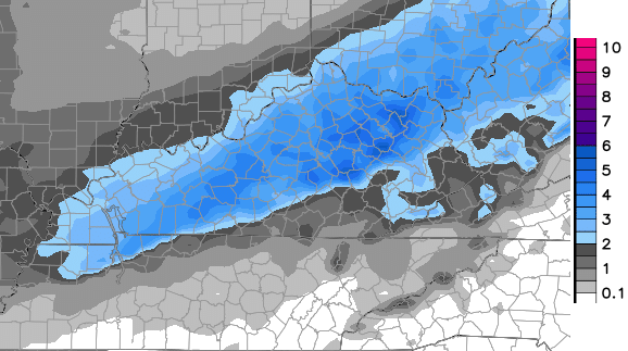
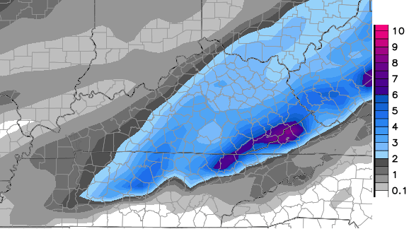
It does show more of a mix to start across southeastern Kentucky. That’s why totals are lower there. The regular GFS has had a lot of issues finding and losing this system over the past 24 hours. The latest run found it again, but is just a bit farther to the east than the Hi Res version…
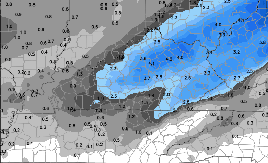
The new run of the European Model looks like a blend between the two versions of the GFS…
Here’s the very early call on who has the best chance of seeing accumulating snows…
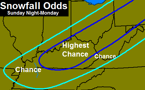
I’m not ready to put numbers on there, but will throw out a First Call For Snowfall later today.
The air behind this system continues to wow me. Readings by Tuesday may be 30-40 degrees below normal around here…

What does that look like in terms of actual numbers? The High Res GFS continues to run on the extreme side of the temperature spectrum…

Record or near record lows and lowest high temps are possible Tuesday and Wednesday.
I will have updates later today. Enjoy your Friday and take care.

Thanks for all you do, Chris! Let it snow!
My thoughts exactly!
Thank you, Chris!
I’m just amazed at this crazy pattern!
Must be the blowtorch effect. 😛
If you’re in eastern ky gotta love the shift of the models.especially the Euro…The older version of the GFS this morning has something special…Nam ain’t there yet but give it another day…
The people who are already camping at Best Buy for Black Friday have got to be freezing their rears off! LOL
….. There are people already camping? Their time must be worth pennies on the dollar 😉
If Best Buy gave me a free tv I wouldn’t wait out in this weather. No way!!!
6z runs have came in. 6z GFS has main snow band just southeast of Lexington. Meanwhile, NAM still out to lunch and not in line with all other models. NAM showing snow band in Indianapolis. Today should be the day where models start lining up (hopefully) and trend northward or southward. Lets see what the 12z runs later today have to say.
And on another note, temps have been busting on the cold side the last few days. Lexington is 20° as of now and has a couple more hours to drop. (Though the only forecaster to get these colder temps right has been CB)
Oh wow nevermind, bluegras-s airport is at 18 degrees! Still a couple more hours to drop even further!!!
Northwest shift with a deepening low will bring the Ohio River counties the snow love. I know the models are shifting east, but the NW shift will be a factor at game time. Always is, Just saying. Got to love a first call map before Thanksgiving. Thanks Chris for all you do.
Roger agrees! Northern shift is almost always a factor in the last 12-24 hours.
Yes, it will…trying not to “rain” on EKY parade, though.
Things can change but EKY may be threading a needle with this one..Nevertheless hope someone in ky get’s a good one..I would guess 3-6 for northern parts if the shift occurs..
In the history of the blog have we ever had a “first call” / “early call” before T’day?
Yes… I can at least remember Hurricane Sandy for EKY
Besides Sandy I can’t remember one in the six years I have been visiting.
Oh yeah — forgot about Sandy…
Great stuff-thanks Chris and posters!
Fingers crossed that my babies get to see some snow !!!
12z NAM trending better for snow. http://meteocentre.com/models/get_accum.php?mod=nam&run=12&type=SN&hi=000&hf=084&lang=en&map=na
For southern Indiana not Kentucky
Just saw it also. This is the beginning of the comparison game amongst the models. I think the totals are forecast too high. I’ve used this snow accumulation map before and it overdoes it a lot. However, even using the specific time frame for the main snow event yields too much in my opinion for this event.. In 24 hours, the NAM will enter its most accurate range. Preliminary thinking is Louisville gets up to 2″ depending on how much other stuff mixes in. Farther south, more mix may cut down on snow totals initially but should still see accumulations late. Southern Indiana – I don’t know. That stripe of heavy accumulations from that run of the NAM just does not look right. But we’ll see what the next few runs have to offer. There’ll probably be a shift.
Agreed
In the word’s of Bryant looks like the Nam is throwing a “Torch” for most of EKY for the Sunday-Monday event..I believe It is getting ready to explode though when it catches on..Now let’s see what the Dumb and Dumber has to say..
NAM looks great, Not! Chill out on the name calling.
As was the case last Winter, I never made one personal attack. All the attitude is coming from those who disagree .
Mark my words, this storm will largely be a no show for KY. It’s an Indiana/Ohio deal.
It’s another UK football Winter-big hat and no cattle
Gee Man chill out..I like your analogy’s..Have not seen any personal attack’s against you..It’s all in fun..
Also if you’re referring to the dumb and dumber comment i was talking about the GFS and the newer version..
Now Bryant you must admit you had this coming after you rattle so many cages on the blog last winter. That whole blowtorch thing last winter was just a tad excessive. Humorous eh maybe for some others not so much.
This system is about as stable as nitro. The trend though is key, but still no converged solution of the more credible models. We could see an inch or perhaps three, but nothing appears to suggest much else so far.
If colder for SE, they could breach three inches, especially the higher areas.
Im thinking the NAM is starting to come around on each run. For the snow lovers the GFS is what your pulling for the Euro looks ok and the GEM says it will be 75 and sunny (just kidding) but it’s not buying into much of anything occurring. Of course this will all change 10 more times between now and Sunday lol
The NAM is usually golden at 48-72 hours. The GFS is fools gold. I expect all major models to converge close to a NAM solution. Want snow? Go to Indiana.
Another year of coulda, shoulda, woulda. Personally, I like the analogy of big hat,no cattle
Wonder what the earliest blog ” first call for snowfall” map record is?
On a warmer note, next weekend giving 50s and possible 60 by Sunday.
Whatever falls, and I’m betting not much, a prolonged period of warmth seems to be in the offing. Which is ok by me, I’d rather get out and bike than sit inside from a cold, gray world that resembles nuclear winter
Winter in Kentucky sucks.
Wondering just how warm Thanksgiving will be too.I would rather have waited till then for these colder temps.A warm Thanksgiving and Christmas makes it not feel so much like the holiday.Hope its cool without being extreme.But most the sites are showing a warm up for Thanksgiving.
Baby it’s COLD outside! It’s 31 degrees here and snow flurries/showers. Also a very cold wind makes things extra cool. I don’t care how much snow we get or if we get any, I’m just glad to know that there is a CHANCE for an accumulation this weekend. Just like to think about that, Chris. Thanks for all you do in forecasting the possibilities.
12z GFS through noon Tues http://204.2.104.196/gfs/WINTER_GFS0P5_SFC_ACCUM-SNOW_96HR.gif