Good Friday afternoon, gang. A significant early season storm system continues to look like it will impact the weather across the bluegrass state. This has the potential to bring a swath of 4″+ snows to parts of our region. Because of this potential, this is now a Winter Storm THREAT.
For those who may be new to the blog, the THREAT level simply means conditions are favorable. It’s meant to give a heads up on the potential and if I become more confident on the event actually happening, I would upgrade to an ALERT. If my confidence goes away, so would the Threat level. Get all that? Good. 🙂
The older version of the GFS is back to grasping reality with a healthy storm system Sunday night into Monday. Here’s the snowfall forecast from the morning run…
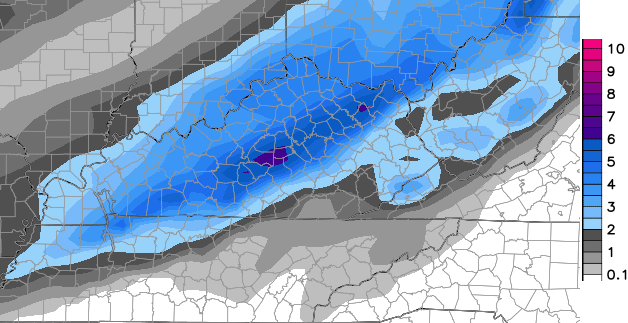
That matches the high resolution GFS very well…
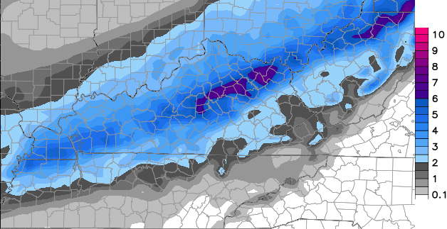
Take the totals with a grain of salt from 48 hours away, but the placement of the axis of heaviest snow is something to hone in on. Those maps play right into my highest chance area from last night…

Of course, that doesn’t mean it will play out like I’m currently thinking, but the new runs certainly help my confidence.
A few thoughts on the setup:
– A period of light snow and flurries may impact parts of central and western Ky Saturday evening and night. The greatest chance appears to be in the north.
– Sunday will find a break between the above system and the one coming in later in the day. A few rays of sunshine could boost temps close to 40.
– Precipitation will break out quickly from southwest to northeast late Sunday afternoon into the evening. Areas in the far east and southeast will likely see this begin as rain or a mix.
– A band of moderate to heavy snow tries to set up across much of the area Sunday night and early Monday. That’s the band that would bring any accumulation where you live.
– Temps tumble on Monday as arctic air sweeps back in. If snow is on the ground, record lows will be a strong possibility by Tuesday morning.
– Watch for some snow showers and squalls to develop as the core of the cold passes over us Tuesday afternoon and evening.
Wintry enough for ya?
I will have a First Call For Snowfall coming your way on WKYT-TV starting at 4. I will then get that posted on the blog this evening.
Remember, the Winter Storm THREAT means I’m seeing the potential for a swath of 4″ snows setting up somewhere across the state. That doesn’t mean it will be on top of your house. Of course, it doesn’t mean it won’t be, either. 🙂
Have a great rest of the day and take care.

ty bAILEY boy… im sticking to a 3-6 inch swath.
Threat mode and it’s not even Thanksgiving yet! Thanks for the update, Chris!
Woo Hoo!!! Here we go!! Let all the blog excitement commence!
BUISNESS IS PICKING UP
Rolo-coasters ROCK!
The waffling of the model ride is probably not done yet, so neither is the rolo-coaster. Did not get to go to Bush Gardens or Kings Island in the past few years, so this will do nicely 🙂 Weeeeeeeeeeeeee!
Haha, Busch Gardens is awesome and so is Kings Island. (But busch gardens is better IMO) Watch a stronger, northward trend in the models next two days. 8″+ possible? Not completely out of the question. I hope I’m wrong and CKY gets in the core of this, but not everyone can be pleased at the same time.
The downside to this is it if temperatures get warmer than expected on Sunday that could also hamper the snow amounts we all see that happen way too many times.
The perfect scenario would be to clear out the sky’s completely Saturday night. Calm wind good raditional cooling to occur then right before dawn a thick cloud cover to move in keep temps in check throughout the day on Sunday. I don’t want to see as much as a ray of sunshine come Sunday and temps topping out no higher than 40. Of course that is in a perfect world and will not happen. lol
Got the grandkids snow boots so we are ready!
If Frankfort gets more than 1 inch. That would be EPIC for so early in the year!
Winter still 5 weeks away officially 😉
To the ones that have lived here for awhile, how often/rare is it to have a thin layer of ice on ponds in mid November? I have pas-sed by several ponds this morning and a thin layer of ice has formed on them early in the season!
I noticed the same thing this morning
Yay!! Bring it on, I am ready!
The best scenario would be for 1 – 2″. It is never good to usher in the snow season with a good dump, because there will be accidents everywhere.
The trend continues for the Monticello area….always in the low end projections. While folks kept snow on the ground several days last winter we fought with the cold temperatures & dry conditions. I’m calling it again this year for my area at least…..very cold winter w/ below normal precip! Until a weather system proves me wrong….that is.
My prediction…. The track will move farther east, Southeast. 🙂
remember the westward trend WE USED TO Always get as storm gets closer, this one though will stay below the cold air and move tad farther east
that was WESTWARD trend what I meant.
stay east this time
Roger says “Wow, a serious snow threat before the home Christmas decorations are up?!” Hoping this is how we roll for the winter of 2014/15!
Some of ya all are snow lovers and I respect that.I’m a snow hater.some of you don’t live in harlan co ky.I do.around here my road which is ky highway 72 catrons creek road gets treated almost last.its hard for me to get out guys.I don’t want the snow.I have plans.
Interesting WPC just added Louisville, Lexington and surrounding areas into the slight risk zone of 4+ inches of snow for the Sunday night/Monday system
Doesn’t meteorological winter start in 2 weeks? Thank you so much CB for all you do. If it’s going to be this cold,than it might as well snow
Holy Moly! A snow day BEFORE THANKSGIVING???? Awesome!!! Yes, business is picking up. Our summer-weather-we-don’t-really-care period is over!!! Back to our obsession with the blog!
Hey now-this is really cool! Love it when the blog is rockin’.
When the blog is a rockin the snow must be knocking 🙂
Perfect, Todd!
I gotta admit, that was a good one!
CB needs to make this his tagline. Hahaha. Good one…
Well the old GFS is trying to give EKY some snow love…Anyone know what the Euro showed today??
Boy the NAM is being stubborn yet persistent on keeping the snow over southern and central Indiana.
The colder temps are along there, so fits as far as a model. We could get more mixing action than expected, but I am sure CB is considering that as we type.
NAM and RPM seem to be considered the outliers, showing the snow band Over southern Indiana. Most of the other models show it actually setting up over KY. I believe that will be the case it’s just a matter of is this going to be a 1-2 strip or 2-6.
Keep in mind the the warm air that will ride with the precipitation for our area. CKY does have the infamous 32/33 rule you know 😉
I’m up in ohio close to Cincinnati.and they are not saying how much we are getting
Four things…
1. Any snow that falls before December 1 is just bonus.
2. It’s good to have Bubba G back.
3. The Rolo-Coaster will be calling for all rain by this time tomorrow night.
4. Which counties will see the snow dome set up over them? (My money is on Madison)
It is the absolute center 🙂 Not a prop for me now since do not want to shovel snow. The snow romance is long gone for me.
I am curious how much falls as rain and mix before the main precip gets here for snow. We know how it tends to play out for anything but clippers.
fingers crossed!!!!!!
I don’t understand the teachers on here. Rooting for snow days, knowing they might have to work deep into the summer..
I don’t either. I work at a preschool, so snow day equals a no pay day for me.
I miss you working for WSAZ. WKYT has a great meteorologist.