Good Friday evening, gang. We are still 48 hours away from the potential for a winter storm to impact much of Kentucky and surrounding areas. I have no changes to my overall thoughts on how this system evolves. But, everyone wants a First Call For Snowfall so here ya go…
 The numbers and placement of the heaviest band of snow may change between now and then, depending on how the storm looks as we get closer.
The models continue to spit out some decent totals. The high resolution GFS continues to lead the snowy charge…
 The regular GFS continues to go back and forth on amounts…
 The European Model has been doing the same…
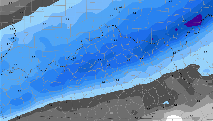
The WPC has much of the region in the slight risk area for 4″+ or more of snow Sunday night into Monday…

I will have a full update coming your way later tonight. Take care.

Thank you Chris.Do you think the Se will get in on the snow Monday morning? It is good to see the Blog come alive. I saw snow flurries off and on most of the day it was pretty. Chris have you started on the decorations or do you still decorate Thanksgiving weekend?
Looks IMO as good as a map can be this far out. Seems there is a little of a northwest trend that also fits the map spread (that and the mix factor). Curious though IF the apparent trend continues how much the main totals remain in Kentucky. Then again I could be confusing the mix impact as a directional trend….
I’m near Franklin and it certainly looks like I’ll be snow chasing north on I-65 on Monday. Let’s do this!
Good luck, Cameron!
Figures. The better half and I will be with her folks in Bowling Green for part of the weekend. Warren County has some shot for heavier snow, and my wife is a bigger winter enthusiast than I am. But by the time the main snow arrives, she will be back at work in Nashville where there may be relatively little snow. ;(
Anyway, thanks CB for all the updates.
A jog to the SE would fit me just fine and
Move us into the higher snow totals.
But this is still great for nov!
🙂
Thx for all you do CB!!!
You rock brother!
19 degrees in southwestern Jefferson County in Louisville, 27 degrees at the airport which is 9 miles away.
Uncanny – northern / central Madison county looks border country — again… still
Ground zero for the D word.
The ground is getting plenty cold. We haven’t broken freezing in two days.
i think the placement of this snow is too far west ….my guess is that 2-5 should be moved east about 50-75 miles
I think the issue is mix impact. Need further north for most of the precip to be snow. We shall see 🙂
Bone chilling cold.Thermometer on the front shows 20 degrees and the one on the fence out back has 16 degrees and its not even midnight yet.
Not looking forward to the cold that is coming next week.This is more than cold enough for me in November.
Looking at the 00Z GFS, I see watches or advisories being issued tomorrow morning/afternoon.
NW shift WILL happen. Ohio River counties WILL be the bullseye! Been here done that.
Music to my Jefferson Co ears!
I lived in Louisville last winter and we got lots of snow. Now I live about 50 miles south so I hope everything is 50 miles south this winter!
So happy to see so many CB fans leaving comments. I have stopped paying attention to our local weather guy since I found Chris. Chris is way out in front of the other guys; starts talking about these weather events WAAAAYYY sooner than anyone else! Thanks CB, you rock! Bring on the snow.
20 here in Morehead. Snow flakes layed on the road this morning-unreal at this time of year! Dare we say Snow Day Monday?! A teacher asking, haha… always a child at heart! Also, other Brodacasters are saying not cold enough, rain changing to snow,,,whatever, but I just don’t get the different reads in the models…HUH?! Go Chris…we love you!
Keep shifting north towards Louisville! C’mon, we all know how this normally ends. The river counties will be in the bullseye!