Good Saturday to one and all. The Winter Storm THREAT continues for Sunday night and Monday. All signs continue to point toward a snowfall for many areas, but who gets the heaviest snow is still up in the air. I’m also tracking possible record cold sweeping in behind that storm.
Let’s get into what’s going on out there today before diving into the Sunday night and Monday system.
Temps this morning are downright nasty for this time of year. A few spots could start the day in the low teens… with a bare ground! Clouds will roll in throughout the day and those clouds could produce a few flurries of a brief period of light snow this evening into tonight. The best chance of that would be across the north.
This brings us to the late Sunday into Monday winter storm potential. A check of the models will find a few late night trends showing up.
The High Resolution GFS continues to show a very heavy band of accumulating snow across western and central Kentucky…

The regular GFS is similar with the placement of this heavy band…

The European Model really wraps up the storm and shows the heavy band just a tad north…
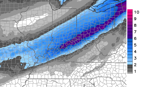
Knowing how the European Model likes to wind up systems a little too much, that is probably too far north.
So what are the trends we’re seeing?
1. The models are insisting on a very heavy band of snow setting up in a southwest to northeast fashion somewhere across our region.
2. The farther southeast you live, the less the chance that band sets up over top of you. These areas also have the best chance at seeing mainly rain before a late in the game change to snow.
The task ahead of me today and Sunday will be trying to pinpoint exactly where this heavy band of snow sets up. I only made some minor changes to my previous call for snowfall…

I will likely make several adjustments to the numbers and placement of the totals over the next 36 hours or so. We’re likely to see Winter Storm Watches go up at some point later today.
The air coming in behind the snow continues to look brutal…

Record lows will be possible for areas with snow on the ground.
The hits don’t end there… another system may bring wintry weather to our region by Thursday and Friday of next week.
I will have several updates throughout the day. Make it a great day and take care.

I’m sure we will see some winter love in the southeast more sooner than later. Everyone enjoy their snow. Thanks cb
Seems an average of the two perhaps, so not as far north and not as central as noted? Whatever the case, just two inches would make it COLD into Monday/Tuesday.
The model trends today/tonight should help tell the tale 🙂
If you remember from a week ago, the thought was “the models are taking into account snow being on the ground for us to get that cold and so keep that in mind looking at those numbers(para)”, as in the cold we have now without the benefit of snow cover. I wonder what we would have it we did see the snow chances (that existed in the models) pan out and put something down?
Record low for Fayette was 14, so I’m betting Madison’s was 15 and might have been tied last night (Mesonet low of 15).
These maps look like countless others from last winter where despite the forecast the cut-off line for accumulation ended at the river or just south enough to barely cover Richmond. I’d feel at least a little hopeful is the ‘swath’ was shaped differently.
Again, snow seems to be trending out of Berea. Sadness, tears! Good luck there in Richmond Bubba
CIip (Clipper) or zip usually for a lot of folks, but not even winter yet. We could see a couple inches, but would not hold breath too long for anything else unless closer to the Ohio river. That is how it seems so far, but CB might see a model trend to suggest more.
I just heard on the news that we recently endured “super storm Hercules” and battled the “polar vortex”. little do I know, I thought it was just cold for November… I have got to get out more.
The national media and the national weather people have to name stuff and brand it. They IMO are part of the problem.
Looks like a very promising start for snow lovers.
I’m looking forward to all the posters comments, predictions, and declarations going into this early storm.
I’ll use today to get some more leaves up around the property.
Thanks so much, Chris!
Storm out west starting to get its act together. Bad part about all this cold, running this morning in my mesh sneakers, I think I got frostbite in my toes!!!
Go Steelers!
I just went three miles (enough for me), but no mesh sneakers.
Wow…if you are a snow lover, don’t look at this forecast just put out by WHAS11 2 hours ago.
Completely different than CB’s.
http://fbcdn-photos-c-a.akamaihd.net/hphotos-ak-xaf1/v/t1.0-0/10635993_311174712419313_6632711477667759983_n.png?oh=85d1b062fa81812dec47c2261fb16c56&oe=54E6EB98&__gda__=1423314217_84d0284887da95dc880447f6cdc39217
Showing an inch or less in places CB has 2-5″ for.
Basically, anyone south and east of Louisville they are calling for an inch or less.
Wdrb in Louisville saying more snow north of the river (southern Indiana) and less south. Wave 3 going 2-3 inches from basically where CB’s 2-5 inches accumulation map is. Wlky I have yet to see a official snowfall map.
Yes, I think wave3 and CB are on the same page for the most part.
As I’ve said, the other station (WHAS) could be right on. I was just posting a comparison pick. Wasn’t trying to get a negative response on their FB page. lol
You are not being negative. The models tend to always look good for our areas with more snow early on and then drift to less when reality time.
Where is the Rolo-coaster? We have had up, down, up and seems time for another down 😉
On a positive, the even has not happened so still a chance. Just not seeing a trend suggesting a significant mid diagonal hit for KY.
Bubba buster?
This is why we visit CB and the kentuckyweathercenter…..even if we are from Louisville. NW jaunt will put the river counties in the heavier band. I like the Euro.
I basically just got told by the WHAS meteorologist, the map CB has out is mainly for the Lex area and they have not seen ANY data indicating upwards of 5″ in the Louisville area.
Sigh….they could very well be correct. But, to say you’ve seen zero data verifying the “potential” for upwards of 5″ is not true.
Anyway, good to see all the regulars coming back to the blog. 🙂
Even 1-2 inches of snow is pretty impressive here especially how early in the season it is.
Exactly… November accumulating snow is a major bonus.
Can you imagine it happening twice in November?
Roger noticing newer model runs putting the “heavier” snow in Indiana and out of Kentucky. Most of KY probably will see more snow from the showers Tuesday than from the Sunday event.
I like the blend between the gfs and Euro.
it’s amazing less than 24 hours before the event begins, and still No consensus.
A key though is the directional trend though and none so far suggest a SE one. All appear to have some NW emphasis to some degree in spite of the heavy band placement. Seems an average of them is best.
1″ to 2″ seems the main total for most of us- the further from the Ohio river. An early Bubba buster though is fine by me 🙂
Looks like the same setup that seky had all last winter. Rain to a few back end flakes. Hard to get the rain to make the changeover in seky. Could see a back end dusting to an inch though
Lived in the ville last winter and saw lots of snow. Now I live 50 miles south. Looks like I should’ve stayed in the ville if I wanted snow!
I bet Burgin gets nothing. We got very little snow in years.