Hey gang. I’m about to head out the door to hand out #WKYTRulesWinter snow measuring rulers for you to use this upcoming winter. I will be at Raising Cane’s Hamburg location in Lexington from noon-1. Come on by and grab a ruler and some chicken. 🙂
Before I go… some quick thoughts.
The GFS continues to show a band of very heavy snow setting up from southwest to northeast. The models are just a tad north of their previous runs with this band. Some more back and forth is likely, but the farther south and east you live, smaller the chance at seeing decent snows.
The regular GFS…

The High Resolution GFS…
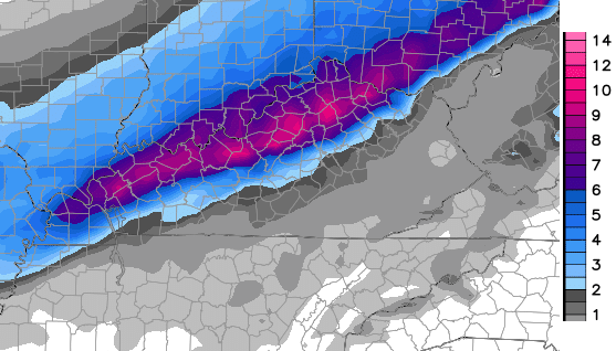 That is probably taking the snow to the extreme, but a heavy band of snow is likely to set up somewhere across this region.
I will have another update after I hand out some rulers and woof down some chicken.
Take care.

Oh well another model flop for Ky. By the time tomorrow rolls around this will be in Ohio and Indiana. Maybe we’ll get a Rolo storm later on lol.
What’s that in the field? Why, it’s Berea waving bye-bye to the snow. Hope you in the northern counties enjoy it. Make a snowball in our honor. lol
I hope the hi-res GFS is proven right, especially with this run. Would be an awesome snow for the river counties in WKY. 😀
Roger lived in Owensboro for several years. Saw some big snows there and LOTS of disappointments too.
Wow, the snow is tracking more toward the northern counties. What a shock. Its going to be the same ol thing again this year. You got the haves and the havenots, and I’m in one of those havenot counties. Sorry, I had to vent.
Unfortunately, some trends cant be broken.
John Belski tweeted around 30 minutes ago that Louisville is in the slight chance zone for a 4+ inch snow.
I like the position Louisville is in, it really comes down to how well the low performs
As usual we get all excited about a big snow and then the day before, oops, it looks like it will miss us. We will get a light dusting.
Yep used to rain and dusting in Somerset.
Looking at all the models signs point that north central Ky is setting up to be the bullseye.
Lived in the ville last winter and saw lots of snow. Now I live 50 miles south. Looks like I should’ve stayed in the ville if I wanted snow!
Roger thinking counties along Ohio River and north have best chance of seeing measurable snow. If this evening’s model runs verify this, I’d say we’ll start seeing some WSWatches in those areas!
To early for snow. Glad the system is pulling north. I hope the bulk of snow goes into Indiana and Ohio. Glad to see Eastern ky will get nothing to a dusting.
Wish I could drop by, but I live outside of Louisville. I ate at the new Raising Cane’s in Louisville Thursday, and the food is great. They do one thing, chicken fingers, and they do them right.
SE KY forecast….lots of rain at 33 degrees. Quick inch of wet snow…turns to ice. Topped off with wrap around/upslope snows, and cold. Sounds familiar? I guess we’ll all smile and enjoy the science of it all. Have a great day everyone!
I do not know if a Winter Storm Watch will be issued or not. However, at the very least an Advisory should go into effect for several areas of Kentucky. An upgrade to warning status could still occur without a Watch in effect. It just depends on the possible development and definite locations that could be impacted by any banding of heavy snow. For Louisville, A WSWatch will be issued if 3-5″ is expected to accumulate within a specified time period or other impactful winter storm conditions are forecast to occur. Right now, I’m expecting up to 4″ for some of us but don’t know where that banding may occur if it does develop. It’s possible that some areas could see more than 4″. But I’m not on board yet.
The Louisville mets are still waiting to see what is going to happen Sunday night. Some are saying possibly 2 to 4 inches. Some are saying I don’t know yet. They are throwing out the gfs and nam and are going in between the 2.
I still think southern Indiana to Bullitt Co., Ky will be in the “sweet spot”.
will i-65 in south central get 2-5 inch of snow
New 12z Euro places the bullseye snow totals along the river and to points north and east.
Accuweather said up ton4 inches here in greenup
Wow! The 12z runs were big eye catcher.
Since when have 4 seperate models been in agreement?
GFS, GFS 13K, CAN, EURO…all of them going big on the Ohio River counties. Putting Louisville in the 6″+ range.
I’m sniffing a possible Winter Storm Watch if the 18z data comes back with similar numbers.
Whatever you guys do, don’t tell a certain MET from WHAS about these latest trends. He is certain nobody will see more than 3″ anywhere. 😉
He’s a new meteorologist will let it slide. lol
The Louisville mets won’t commit to a forecast. It’s tomorrow when this is supposedly going to happen. It’s become laughably bad over time.
I can’t fully blame them for not wanting to pull the trigger (so to speak).
Louisville has had many more busts over the years, and less big surprises.
At any rate, they should start locking in to a solid forecast by nights end.
is that meteorologist Tom wills in disguise.lol
Good ole Tom Tom….he meant well.
I loved when he would say “the angle of the sun and radiational heating in the afternoon will melt most of what falls”. And we ended up with 14″ of snow. This was back during a March storm. Maybe ’08?
He predicted a couple inches. But, he is a nice man. 🙂
Ok, just this time. 🙂
I’m just saying they can’t keep nowcasting every single time it might snow around here. There comes a time when you say what you think and let it roll from there.
The midday models are raising alot of eyebrows with the mets in Louisville.
No big shock. I called it 2 days ago, Indiana or bust.
Get ready for another Winter of big potential.
Somebody please turn off the torch.
If you go by what the WPC thinks it might be Southern Indiana that gets the most snow. Keeps going more north with every model run.
I just got in from raking leaves so my lawn will look prettier w/ that (ahem! Cough!) “potential” big snowfall. Wish on, Debbie, wish on! It’s a known fact that Bardstown is the “Toe-Tingler Center of the Universe”, and it always hits Bullitt Co. on northward, despite the whiners that always claim that the Ville “never gets snow”…lol…if you get more than 37 flakes in one hit, then you’ve gotten around 19 more flakes than I did. (Or in most cases, 37….) (No “Debbie Downer” jokes, please….tyvm!) Just a big snow-lover here and wishing for more than what I’ve seen in the past 4-5 yrs. 🙂
Louisville and southern Indiana folks should follow their own guys, like Brian Goode from Wave. Most of us are tired of the Louisville never gets snow schtick
It’s called Kentucky Weather Center. Last time I checked Louisville was still in Kentucky.
Don’t matter, this will be central Indiana’s storm before it’s all said and done.
Can we end analogue year comparisons to the late 70s? There is no comparison. Let’s enjoy our rain and Thanksgiving week warmth. Another wasted cold shot