Good evening, gang. All eyes continue to be focused on the Winter Storm Threat for Sunday night and Monday, but a sneaky band of some light snow and sleet is streaking in this evening. This isn’t a big deal and has already been touched on over the past few days.
I wanted to stop by to offer some tracking toys and to get the word out about this evening’s light stuff.

The above radar will give you a lot of false colors, but with dewpoints in the teens, light snow and sleet will be the main players. A rooftop duster is possible as this band works in.
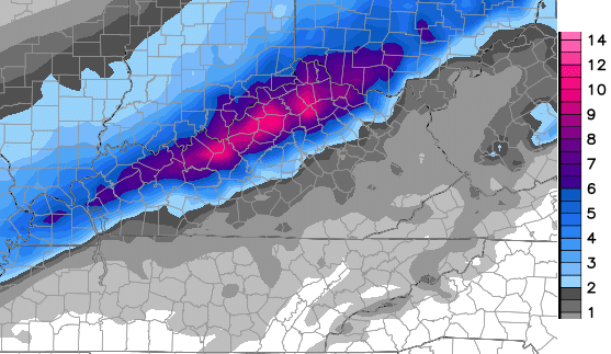
The late afternoon runs of the GFS pretty much held steady with the Sunday night and Monday snowfall numbers…
High Resolution version…
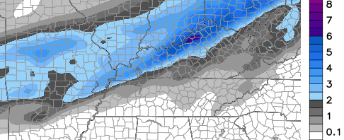
 Regular run…
 As one who is ALWAYS looking ahead, I’m already keeping one eye on a system for the end of next week…
 That could bring another round of winter weather our way. This is a super wintry pattern for the middle of NOVEMBER! Let me say this… If you are a winter weather lover, you should be loving this fall storm track! It bodes well for the months ahead of us.
Speaking of winter signs. Check out my tweets from earlier…
Lexington tied the record low of 14 degrees today. That record was first set back in 1916. #kywx
— Chris Bailey (@Kentuckyweather) November 15, 2014
This morning’s 14 degrees is the coldest temp this early in Lexington since 1951. #kywx
— Chris Bailey (@Kentuckyweather) November 15, 2014
Take care.

Great another cold rain late next week. The only people who believe winter can produce a healthy snow are the same ones that buy into UK football winning the SEC
Looks to be moving north…. 🙁
It always trends north, maybe someday it will come our way in Southern Kentucky. It is fun to dream though.
I’m not loving it Chris it’s missing eastern ky just depressing me
At that rate the system flowing north NW, most of us might be getting a dusting to an inch unless near the Ohio river.
I’d be surprised if you didn’t have that comment macro’d from last season and just hit a button to make it appear. 😉
😉 🙂
We missed most of the big rains of the summer– when everyone else got 2-3 inches we would get 1/2 inch or so. Same thing last winter. The biggest snow we had fell on December 8 and we had 4-5 inches. The other snows were 1-2 inches and that was that. Lots of cold and 25 missed days of school for small nuisance snows and flu. But I think this winter may be different. We may not get it this weekend or next week, but Winter is out there. AND, one day UK WILL win the SEC and I hope I’m around to see it.
How old are you?
Do think Advisories will be going up for a line from E’town through Lexington and points north of that. Am a bit concerned about when complete changeover will occur as today’s models have seemed to ‘warm’ things up a bit. Awaiting 00z run of the NAM, which should have the best handle on this storm system by now. After that, nowcast mode using RAP.
00Z NAM… farther south, and a little weaker? Or, wound up, wet, slushy, and farther north?
Weather models are like most people models: They ain’t got no’ brains 🙂
If you like rain the NAM is for you.
CB’s last tweet about 8 minutes ago:
“The new NAM is finally sniffing things out. Looks a lot more like what the GFS has been advertising for days now.”
I think its funny how people think 4″ is a huge snowfall , if those same people ever got a 12″ snow , it would be fun to hear them talk about it
4” is a huge snowfall around here considering we only average 13” for a whole winter.
It’s November child!
The NWS service in Louisville issued a Winter Weather Advisory for the Ohio River counties. They mentioned could issue a Winter Storm Warning but if they did sounded like it would be for Southern Indiana.
Very unusual to see a one inch snow, much less than a Warning Criteria Snow anywhere in Central Kentucky in November. The NW trend looks good for now, even though it is fairly unusual to see a warning criteria snowfall this early across the Ohio River. I think the cold is the more impressive story.
it all comes down how many miles does the low jog off course.
a swing of 50 miles can make the difference from several inches to a heavy snow event.
like I said all day I like the geographical position Louisville is at.
any snow we receive is a bonus before Thanksgiving.
think I’ll go to bed and wait for December…..Good night..
The GFS and Parallel GFS look pretty much the same. The Parallel GFS might be a tad north but not that much from earlier today.
I only come here to read the comments (eating popcorn) I enjoy reading comments from snow lovers that miss out or only receive rain 🙂 Melt down comments are fun. BTW No pun intended with the word “melt” Have a great week and lets not forget its only November ha