Good Sunday to one and all. It’s mild and super windy out there today as we track an increase in showers from west to east. While the showers increase, the temps are set to decrease in a big way on Monday. That temp drop is likely to deliver a wintry mix of precipitation to some areas. It also kicks off a busy first week of December.
Temps today will hit 60-65 in many areas with winds that may reach 40mph in gusts. Those showers pick up during the afternoon and evening as the arctic front nears.
Sustained Winds

Current temperatures


Temps late tonight into Monday will take drop in a big time way. Many areas will see a 20-30 degree temp drop in just a few hours as the arctic front slips in. Check out these temp forecast maps from around noon Monday…

 As the cold air sinks in, we are likely to set the stage for a swath of mixed precipitation. Some sleet, freezing rain and snow will likely be noted in a west-east swath Monday afternoon and evening. The best chance of this appears to be along the Interstate 64 corridor. The European continues to be the most aggressive with the coverage…
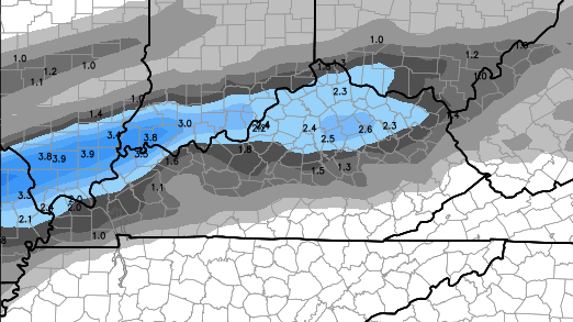
Again, don’t look at the “how much” part of that map. It’s actually trying to show us where the highest chances for frozen precipitation are. There will be the potential for some accumulation of the frozen stuff and that could create a few travel issues.
The aforementioned front will then meander across our region through the rest of the week. That’s likely to set up a healthy temperature gradient with temps oscillating from day to day. One day could feature highs near 50 with the next day around 40 with the next day around 50 with the next day… you get the idea. It’s also the pattern that can throw the occasional 60 your way over the next week or so.
It’s also a very ugly setup with clouds galore and a lot of rain… A LOT of rain! That wet pattern will lead us back into a very wintry one for the middle and end of the month.
I will update things later today. Take care.

Question:
This site has not loaded for a few days now. I wonder why? It’s the weather radar loop that you can look at for the past 24 hours.
rap.ucar.edu
Was showing nelson county in the sweet spot a few days ago and per the trend that ALWAYS happens, it has shifted north. Hrmph.
There never really was a sweet spot. The Euro was the most aggresive with any real snow accumulation (even that wasnt that impressive). Euro didnt have any or much support from the other models with any real measurable snowfall, cold temps yes but any real wintery threat not so much. There might be some sleet mixing in maybe a snowflake or two, freezing drizzle but nothing of any consequence for tomorrow. Just temps a dropping through out the day but nothing we havent already experience as of late.
Remember MSM (Mike’s snow model)? Take the axis three days out and shift it 75 miles northwest. ELt’s see how it plays out. So far it is 1-1. (One system I followed did just that, the other didn’t really.)
Thank you Chris for the update. I hope you and your family had a good Thanks Giving. We appreciate all you do for us.
70 degrees in Paducah it looks like alot of the Commonwealth will make a run at 70 degrees today. I’ll take these kind of temps in November all day long.
It’s 72 here in Louisville and it feels great.
alright now chris…..the bengals have won and the steelers and ravens and browns have all lost…….now we need an update……..lol
and your beloved cats has won also…..now time for some weather talk….lol
chris, you said to never underestimate a nw wind in the winter time, well it looks as though we may have underestimated the ssw wind this sunday afternoon my friend.
Yes toney…WHO DE and Go CATS.
The weather though looks normal next 10 days. Hope it turns colder and snow after that