Good evening. Foggy conditions continue to blanket mos of the bluegrass state. Scattered showers and patchy areas of drizzle are also noted out there. Watch for the rains to pick up across the east and southeast into tonight.
The short term forecast remains the same with chilly temps and a lot of clouds. Those clouds will eventually open up on us with heavy rain for Friday and Saturday.
I keep watching things for the first half of next week. That’s when a system digs in from the northwest and tries it’s very best to create a bigger storm system across the eastern part of the country. I showed you the Canadian model earlier today and it was showing such a system.
The Candian Ensembles back it up with a deep system across our region…
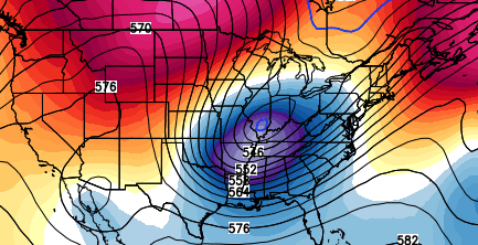
Notice how similar that is to the morning run from the GFS Ensembles…
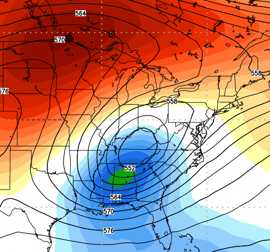
The regular GFS is slowly figuring out there is a system diving in from the northwest…
 It isn’t to the extreme as the Canadian or GFS Ensembles, but it’s a start.
Enjoy your evening and take care.

A word map for the blog at the end of the month tracking “rain” against “snow” or “wintry” or “mix” or “ice”…this will be an interesting result.
The crystal Bubba ball shows mainly snow for I64 on north and mix the further south from there. Package it and sell it for the winter 😉
I just hope ice stays out of the picture, but most of us know it probably is more likely than big snow for south of I64. That is unless we get a super clipper, or a “Snowlar” Vortex. I made that one up 🙂
hey! Great new word. Maybe it will bring us some snow luck. Nothing else has.
7 days away. If I had a dollar for every….., well you know the drill.
Did you guys miss last winter or the November we just wrapped up?
I’ve enjoyed the cold, Just want to see the big one finally hit Versailles and areas south of 64
Nice work Chris! Thanks for the update.
I see threat mode a coming!!!! Just a gut feeling a week out. Lol
Am I hearing another “weekaway” is on the way?
What does that mean?
Keep it clean now CB. The term “a week a way” is often laughed at.